Category:Fort Brown (Albany District)
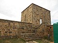
English: Fort Brown at Hermanus Kraal, beside the R67 or Queen's Road and near the Great Fish River, is one of a chain of 19th century forts built on the Eastern Cape frontier, South Africa. It was expanded in 1834/35 and completed in 1838. It was declared a heritage monument 100 years later in 1938. Graves of 9 soldiers that died in 1852 are situated nearby.
| Object location | | View all coordinates using: OpenStreetMap |
|---|
 | |||||
| Upload media | |||||
 | |||||
Media in category "Fort Brown (Albany District)"
The following 3 files are in this category, out of 3 total.
-
 Fort Brown, Albany District.JPG 4,320 × 3,240; 870 KB
-
 Fort Brown, Eastern Cape (9258748709).jpg 6,016 × 4,000; 2.4 MB
-
 FortBrown-FishRiver-SouthAfrica.JPG 1,024 × 768; 172 KB

.jpg)