Category:Fortifications of Charleroi
 Charleroi au 17e siècle (vue depuis le Sud). | |||||
| Upload media | |||||
| Instance of | |||||
|---|---|---|---|---|---|
| Named after |
| ||||
| Location | Charleroi, Arrondissement of Charleroi, Hainaut, Walloon Region, Belgium | ||||
| Inception |
| ||||
| Significant event |
| ||||
| |||||
Subcategories
This category has the following 3 subcategories, out of 3 total.
Media in category "Fortifications of Charleroi"
The following 24 files are in this category, out of 24 total.
-
 Plan de Charleroi.jpg 2,742 × 2,081; 946 KB
-
 Fortifikationskarta över Charleroy,1709 - Skoklosters slott - 99059.tif 4,726 × 3,389, 2 pages; 45.85 MB
-
 A plan of Charleroi 1693.jpg 861 × 670; 137 KB
-
 Charleroi - borne G80 - rue des Gardes.jpg 2,304 × 3,072; 3.43 MB
-

-
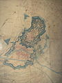
 Charleroi - forteresse - plan de 1667.jpg 4,496 × 3,064; 1.83 MB
-
 Charleroi - forteresse hollandaise - 1854-1855.jpg 2,304 × 3,072; 1.94 MB
-
 Charleroi - forteresse hollandaise - bastion Amsterdam.jpg 3,072 × 2,304; 1.96 MB
-
 Charleroi - forteresse vers 1816.jpg 5,387 × 4,167; 12.8 MB
-
 Charleroi - place Charles II - puits - vue de dessus.jpg 5,184 × 3,456; 10.75 MB
-
 Charleroi - place Charles II - puits.jpg 3,072 × 2,304; 5.4 MB
-
 Charleroi - rue de Dampremy - escalier des rames.jpg 2,304 × 3,072; 1.93 MB
-
 Charleroi - rue de France n° 9.jpg 2,304 × 3,072; 4.42 MB
-
 Charleroi - rue des Gardes 6.jpg 2,304 × 3,072; 4.75 MB
-
 Charleroi plan de 1693.jpg 7,536 × 6,109; 33.51 MB
-
 Charleroi-Mambourg-forteresse hollandaise.jpg 3,072 × 2,304; 2.74 MB
-
 Charleroi-vauban.jpg 979 × 731; 126 KB
-
 Charleroy - paysage au 17e siècle.jpg 3,215 × 1,238; 2.92 MB
-
 Charleroy - plan de ville en 1680 - document cartographique manuscrit.jpg 8,609 × 6,747; 6.93 MB
-
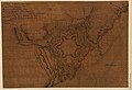
 Charleroy - siège de 1667 - document cartographique manuscrit.jpg 10,578 × 6,320; 8.13 MB
-
 Coronelli - Mons, Charleroy, Namur, Lewe.jpg 6,519 × 4,947; 3.61 MB
-
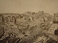 Démolition des fortifications de Charleroi.jpg 1,024 × 768; 240 KB
-
 Plan de Charleroi par Roussel ingénieur du roi en 1694.jpg 4,434 × 4,663; 15.78 MB
-


,_RP-P-AO-19-44B.jpg)