Category:Francis Scott Key Bridge (Washington, D.C.)
| Object location | | View all coordinates using: OpenStreetMap |
|---|
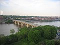
bridge in Washington, D.C.   Plaque on the Key Bridge's northern terminus in Washington, D.C. _-_panoramio.jpg) Rosslyn as seen from Georgetown  | |||||
| Upload media | |||||
| Instance of | |||||
|---|---|---|---|---|---|
| Named after | |||||
| Made from material | |||||
| Location |
| ||||
| Architectural style | |||||
| Architect |
| ||||
| Commissioned by | |||||
| Crosses | |||||
| Carries | |||||
| Heritage designation |
| ||||
| Inception |
| ||||
| Date of official opening |
| ||||
| Length |
| ||||
| Elevation above sea level |
| ||||
| Structure replaces | |||||
| Cost |
| ||||
| Different from | |||||
 | |||||
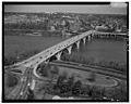
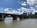
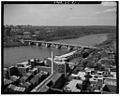
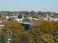
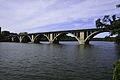
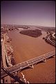
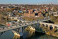
English: The Francis Scott Key Bridge, known as the Key Bridge — a 1923 bridge over the Potomac River, between Washington, D.C. and Virginia.
- The road bridge carries U.S. Route 29 between the Georgetown neighborhood of Washington, D.C., and the Rosslyn area of Arlington County, Virginia.
Subcategories
This category has the following 2 subcategories, out of 2 total.
Media in category "Francis Scott Key Bridge (Washington, D.C.)"
The following 108 files are in this category, out of 108 total.
-
 Washington - West from Washington Monument (1965) (4383150483).jpg 1,250 × 655; 399 KB
-
 Washington - Key Bridge from Washington Monument (1968).jpg 1,050 × 684; 424 KB
-

-

-

-

-

-

-

-

-
-
 Across the Bridge to Rosslyn (52476152105).jpg 4,800 × 3,000; 17.22 MB
-

-
 Aerial view of Georgetown, Washington, D.C. 14570a.tiff 2,318 × 1,530; 20.32 MB
-
 Aerial view of Georgetown, Washington, D.C..jpg 1,024 × 676; 372 KB
-
 Aerial view Rosslyn & Georgetown DC 06 2011 2451.JPG 1,000 × 1,500; 1.47 MB
-
 Aqueduct Bridge Abutment Wash DC.jpg 3,925 × 2,944; 8.35 MB
-
 Aqueduct Bridge and Rosslyn skyline.jpg 2,048 × 1,536; 1.09 MB
-
 Bridge over the frozen Potomac River, at dusk, 2010 01 15 -a.jpg 3,968 × 2,976; 1.34 MB
-
 Bridge over the frozen Potomac River, at dusk, 2010 01 15 -b.jpg 3,968 × 2,976; 1.09 MB
-
 Bridging the Gap - Dan Solley.jpg 6,016 × 4,000; 2.78 MB
-
 C & O Canal LCCN2016840143.jpg 5,241 × 4,215; 3.34 MB
-
 Chesapeake and Ohio Canal and Key Bridge.jpg 2,048 × 1,536; 990 KB
-
 Construction Work on Key Bridge, June 1948.jpg 4,203 × 3,012; 779 KB
-
 DCA 03 2013 Key Bridge 6179.JPG 4,330 × 1,800; 5.78 MB
-
 DCA 03 2013 Key Bridge panorama 6178.JPG 3,020 × 1,200; 2.91 MB
-
 DCA 03 2013 Key Bridge Rosslyn panorama 6186.JPG 6,058 × 1,600; 6.53 MB
-
 DCA 03 2013 Key Bridge Rosslyn panorama 6195.JPG 6,741 × 1,800; 9.12 MB
-
 DCA Georgetown U & Key Bridge 03 2013 6197.jpg 6,188 × 1,600; 6.21 MB
-
 Foggy Bottom, framed - Washington, D.C..jpg 2,448 × 2,535; 1.84 MB
-
 Francis Scott "Key" Bridge with Rosslyn in the background.jpg 1,896 × 1,488; 394 KB
-

-

-
 Francis Scott Key Bridge Washington DC LCCN2016823374 (cropped).jpg 6,221 × 4,753; 2.93 MB
-
 Francis Scott Key Bridge Washington DC LCCN2016823374.jpg 7,080 × 5,472; 3.46 MB
-
 Francis Scott Key Bridge, Washington, D.C. LCCN2016889646.jpg 7,752 × 10,008; 8.72 MB
-
 Francis Scott Key bridge.jpg 3,840 × 2,160; 2.26 MB
-

-
 Georgetown bridge.jpg 1,024 × 768; 294 KB
-
 Georgetown Slavery Archive Editing Workshop 2024912.jpg 4,032 × 3,024; 5.52 MB
-
 Georgetown view from the Teddy Roosevelt Bridge.jpg 1,314 × 782; 225 KB
-
 Georgetown Waterfront Park - Washington, D.C..jpg 2,747 × 2,095; 1.49 MB
-
 Georgetown waterfront park key bridge.JPG 1,600 × 1,200; 340 KB
-
 Georgetown, Key Bridge, Rosslyn Circle (1965) (4409875258).jpg 1,250 × 736; 481 KB
-
 Georgetown, Washington, D.C. HDR.jpg 3,194 × 2,311; 3.56 MB
-
 Heaven On Earth 201 (cropped).JPG 3,247 × 2,024; 4.05 MB
-
 Heaven On Earth 201.JPG 4,232 × 2,803; 5.97 MB
-
 Key Bridge (enhanced) (3384329523).jpg 3,648 × 2,736; 991 KB
-
 Key Bridge - plaque.jpg 2,048 × 1,536; 1.45 MB
-
 Key Bridge aerial view.jpg 1,024 × 823; 146 KB
-
 Key Bridge and aqueduct pier.JPG 601 × 474; 62 KB
-
 Key Bridge and Rosslyn.jpg 2,048 × 1,536; 768 KB
-
 Key bridge arch.jpg 1,625 × 3,135; 802 KB
-
 Key Bridge DC 1992.jpg 1,024 × 818; 81 KB
-
 Key Bridge DC and Gergetown 1992.jpg 1,024 × 818; 130 KB
-
 Key Bridge DC View.jpg 2,048 × 1,536; 1.79 MB
-
 Key Bridge fall foliage.JPG 2,048 × 1,536; 1.6 MB
-
 Key Bridge from DC side.jpg 3,680 × 2,456; 7.94 MB
-
 Key Bridge Georgetown waterfront Washington DC 2023-10-28 07-53-55.jpg 8,256 × 4,644; 22.48 MB
-
 Key Bridge in DC full length.JPG 2,048 × 1,536; 1.55 MB
-
 Key Bridge in DC.JPG 2,048 × 1,536; 2.32 MB
-
 Key Bridge LCCN2016823373.jpg 7,040 × 5,489; 2.73 MB
-
 Key Bridge LCCN2016823374.jpg 1,024 × 791; 112 KB
-
 Key Bridge LOC npcc.07735.jpg 5,258 × 4,186; 3.56 MB
-
 Key Bridge plaque.jpg 3,452 × 2,471; 2.27 MB
-
 Key Bridge seen from Watergate complex.jpg 512 × 384; 42 KB
-
 Key bridge under cons't. LCCN2016827040.jpg 7,129 × 5,505; 3.6 MB
-
 Key Bridge under const. LCCN2016826861.jpg 5,376 × 4,332; 2.26 MB
-
 Key Bridge under const. LCCN2016826862.jpg 5,334 × 4,333; 2.43 MB
-
 Key Bridge under const. LCCN2016826863.jpg 5,375 × 4,356; 2.91 MB
-
 Key Bridge under const. LCCN2016829130.jpg 5,376 × 4,362; 1.87 MB
-
 Key Bridge view from K Street.jpg 2,057 × 1,361; 1.26 MB
-
 Key Bridge viewed from Potomac River shore.jpg 2,048 × 1,301; 884 KB
-
 KEY BRIDGE, LOOKING NORTH FROM VIRGINIA TO THE DISTRICT - NARA - 546686.jpg 2,025 × 3,000; 1.02 MB
-
 Key Bridge, viewed from the river -01- (50865027698).png 2,816 × 1,877; 7.56 MB
-
 Key Bridge, viewed from the river -02- (50865027758).png 2,816 × 1,877; 7.53 MB
-
 Key Bridge, viewed from the river -03- (50865027753).png 2,816 × 1,877; 6.84 MB
-
 Key Bridge, viewed from the river -04- (50865743676).png 2,816 × 1,877; 6.11 MB
-
 Key Bridge, Washington D.C.jpg 487 × 365; 45 KB
-
 Key Memorial Bridge LCCN2016826251.jpg 6,427 × 5,066; 3.68 MB
-
 KeyBridge-DC.jpg 2,000 × 1,222; 847 KB
-
 KeyBridge1.jpg 2,000 × 841; 508 KB
-
 KeyBridge3.jpg 2,000 × 1,333; 909 KB
-
-

-
 Military vehicle Key Bridge30683v.jpg 956 × 701; 447 KB
-
 Military vehicles key bridge 30683a.tif 10,068 × 7,320; 140.57 MB
-
 NWDCgeorgetown (cropped).jpg 1,599 × 1,066; 987 KB
-
 NWDCgeorgetown.jpg 2,000 × 1,333; 880 KB
-
 Potomac and Key Bridge.jpg 3,456 × 5,184; 3.92 MB
-
 Potomac Boat Club 3b38705u.tif 1,536 × 1,151; 1.69 MB
-
 Potomac Boat Club, Washington DC.jpg 682 × 1,024; 236 KB
-

-
 Recreational boats float under a Potomac bridge.jpg 1,575 × 1,575; 275 KB
-
 Rosslyn as seen from Georgetown (March 9, '04) - panoramio.jpg 2,272 × 1,704; 1.1 MB
-
 Rosslyn skyline April 2022.jpg 2,048 × 1,536; 862 KB
-
 Rosslyn Skyline in 2018.jpg 2,899 × 2,071; 1.41 MB
-
 Rowing on the Potomac River, Washington DC -a.jpg 1,024 × 682; 150 KB
-
 Stand up scene (8712578924).jpg 3,264 × 1,836; 1.5 MB
-
 Tank at key bridge 30687a.tif 6,885 × 9,415; 31.5 MB
-
 Tank; Key Bridge in background30684v.jpg 980 × 703; 457 KB
-
 Tank; Key Bridge in background30687v.jpg 700 × 980; 250 KB
-
 The Aqueduct along the C&O Canal in Georgetown (b4bde31b-601e-4931-9beb-8eeea045485c).jpg 5,059 × 3,373; 5.28 MB
-
 THE KEY BRIDGE TO VIRGINIA CROSSES THE POTOMAC AT GEORGETOWN - NARA - 546569.jpg 3,000 × 2,010; 855 KB
-

-
 Washington - Key Bridge (4408832201).jpg 1,000 × 667; 243 KB
-
 Washington - Key Bridge and Georgetown from Arlington (4408054515).jpg 1,050 × 700; 354 KB
-
 Washington - Key Bridge from Arlington (4409599184).jpg 1,000 × 667; 350 KB
_(4383150483).jpg)
.jpg)
_crossing_the_Potomac_River_from_Washington,_D.C._to_Arlington_County,_Virginia.jpg)
_at_the_south_end_of_the_Francis_Scott_Key_Bridge_in_Arlington_County,_Virginia.jpg)
_crossing_the_Potomac_River_from_Arlington_County,_Virginia_to_Washington,_D.C..jpg)
_crossing_the_Potomac_River_from_Washington,_D.C._to_Arlington_County,_Virginia.jpg)
_crossing_the_Potomac_River_from_Washington,_D.C._to_Arlington_County,_Virginia.jpg)
_crossing_the_Potomac_River_from_Arlington_County,_Virginia_to_Washington,_D.C..jpg)
_from_36th_Street_NW_in_Washington,_D.C..jpg)
_from_33rd_Street_NW_in_Washington,_D.C..jpg)

.jpg)


.jpg)


_(4409875258).jpg)

.JPG)

_(3384329523).jpg)


.png)
.png)
.png)
.png)


.jpg)


.jpg)


.jpg)


.jpg)
.jpg)
.jpg)