Category:Freibergsdorfer Hammer
| Object location | | View all coordinates using: OpenStreetMap |
|---|
 | |||||
| Upload media | |||||
| Instance of | |||||
|---|---|---|---|---|---|
| Location | Freiberg, Mittelsachsen, Saxony, Germany | ||||
| Street address |
| ||||
| Heritage designation | |||||
 | |||||
| (Wikidata) |
Media in category "Freibergsdorfer Hammer"
The following 83 files are in this category, out of 83 total.
-
 20181106300DR Freiberg Freibergsdorfer Hammer Hammerteich.jpg 3,648 × 2,730; 7.33 MB
-
 20181106315DR Freiberg Freibergsdorfer Hammer.jpg 3,476 × 2,642; 6.55 MB
-
 20181106320MDR Freiberg Freibergsdorfer Hammer.jpg 3,814 × 2,611; 6.79 MB
-
 32399-Freiberg-2000-9-teilig-Brück & Sohn Kunstverlag.jpg 3,488 × 2,500; 4.5 MB
-
 Denkmalzeichen Freibergsdorferhammer.JPG 3,240 × 4,320; 2.52 MB
-
 Freibergsdorfer Hammer (01sr).jpg 1,703 × 1,154; 1.76 MB
-
 Freibergsdorfer Hammer Gussofen LvT.jpg 2,755 × 4,906; 3.57 MB
-
 Freibergsdorfer Hammer Haemmer LvT 2.JPG 5,184 × 3,456; 6.61 MB
-
 Freibergsdorfer Hammer Haemmer LvT 3.JPG 5,184 × 3,456; 6.82 MB
-
 Freibergsdorfer Hammer Haemmer LvT.JPG 5,184 × 3,456; 6.77 MB
-
 Freibergsdorfer Hammer Hammerabstuetzung LvT.JPG 3,456 × 5,184; 6.25 MB
-
 Freibergsdorfer Hammer Hammergerüst.jpg 4,752 × 3,168; 1.47 MB
-
 Freibergsdorfer Hammer Hammerkopf LvT.JPG 3,456 × 5,184; 6.35 MB
-
 Freibergsdorfer Hammer Hammerstiel LvT.JPG 5,184 × 3,456; 6.28 MB
-
 Freibergsdorfer Hammer Hauptgebaeude LvT.JPG 5,184 × 3,456; 6.49 MB
-
 Freibergsdorfer Hammer Holzmodell LvT.JPG 5,184 × 3,456; 5.95 MB
-
 Freibergsdorfer Hammer Innenhof LvT.JPG 5,184 × 3,456; 7.91 MB
-
 Freibergsdorfer Hammer Kugelhammer LvT.JPG 3,456 × 5,184; 6.18 MB
-
 Freibergsdorfer Hammer Maueranker Frauenkirche LvT.JPG 5,184 × 3,456; 6.12 MB
-
 Freibergsdorfer Hammer Nockenwelle LvT 2.JPG 3,456 × 5,184; 6.69 MB
-
 Freibergsdorfer Hammer Nockenwelle LvT 3.JPG 5,184 × 3,456; 6.43 MB
-
 Freibergsdorfer Hammer Nockenwelle LvT.JPG 3,456 × 5,184; 6.31 MB
-
 Freibergsdorfer Hammer Raederwerk LvT.JPG 3,456 × 5,184; 6.55 MB
-
 Freibergsdorfer Hammer Schmiedefeuer LvT.JPG 5,184 × 3,456; 6.65 MB
-
 Freibergsdorfer Hammer Schmiedegebäude.jpg 4,454 × 3,168; 2.37 MB
-
 Freibergsdorfer Hammer Schmiedeofen LvT.JPG 3,456 × 5,184; 6.62 MB
-
 Freibergsdorfer Hammer Schmiedeteile LvT.JPG 3,456 × 5,184; 6.63 MB
-
 Freibergsdorfer Hammer Spindelpresse LvT.JPG 3,456 × 5,184; 5.89 MB
-
 Freibergsdorfer Hammer Transmission LvT 2.JPG 5,184 × 3,456; 6.32 MB
-
 Freibergsdorfer Hammer Transmission LvT.JPG 5,184 × 3,456; 6.56 MB
-
 Freibergsdorfer Hammer Wasserrad LvT 3.JPG 3,456 × 5,184; 5.87 MB
-
 Freibergsdorfer Hammer Wasserrad LvT 4.JPG 3,456 × 5,184; 5.61 MB
-
 Freibergsdorfer Hammer Wasserrad LvT 5.JPG 3,456 × 5,184; 5.93 MB
-
 Freibergsdorfer Hammer Wasserrad LvT s.JPG 3,456 × 5,184; 5.99 MB
-
 Freibergsdorfer Hammer Wasserrad LvT.JPG 5,184 × 3,456; 6.44 MB
-
 Freibergsdorfer Hammer Wasserzulauf LvT.JPG 5,184 × 3,456; 6.13 MB
-
 Freibergsdorfer Hammer Zahnrad LvT 2.JPG 5,184 × 3,456; 6.57 MB
-
 Freibergsdorfer Hammer Zahnrad LvT.JPG 3,456 × 5,184; 6.32 MB
-
 Freibergsdorfer Hammer Zulaufregulierung LvT.JPG 5,184 × 3,456; 7.45 MB
-
 Freibergsdorfer Hammerwerk 01.JPG 4,320 × 2,432; 4.31 MB
-
 Freibergsdorfer Hammerwerk 02.JPG 4,320 × 2,432; 4.39 MB
-
 Freibergsdorfer Hammerwerk 03.JPG 2,560 × 1,920; 2.95 MB
-
 Freibergsdorfer Hammerwerk 04.JPG 2,560 × 1,920; 2.73 MB
-
 Freibergsdorfer Hammerwerk 05.JPG 2,560 × 1,920; 2.7 MB
-
 Freibergsdorfer Hammerwerk 06.JPG 2,560 × 1,920; 2.97 MB
-
 Freibergsdorfer Hammerwerk 07.JPG 4,320 × 2,432; 4.82 MB
-
 Freibergsdorfer Hammerwerk 08.JPG 4,320 × 2,432; 4.8 MB
-
 Freibergsdorfer Hammerwerk 09.JPG 4,320 × 2,432; 4.53 MB
-
 Freibergsdorfer Hammerwerk 10.JPG 4,320 × 2,432; 3.75 MB
-
 Freibergsdorfer Hammerwerk 11.JPG 4,320 × 3,240; 5.41 MB
-
 Freibergsdorfer Hammerwerk 12.JPG 3,240 × 4,320; 4.84 MB
-
 Freibergsdorfer Hammerwerk 13.JPG 4,320 × 3,240; 4.62 MB
-
 Freibergsdorfer Hammerwerk 14.JPG 4,320 × 2,432; 4.47 MB
-
 Freibergsdorfer Hammerwerk 15.JPG 2,560 × 1,920; 2.85 MB
-
 Freibergsdorfer Hammerwerk 16.JPG 4,320 × 2,432; 4.33 MB
-
 Freibergsdorfer Hammerwerk 17.JPG 4,320 × 2,432; 4.6 MB
-
 Freibergsdorfer Hammerwerk 18.JPG 2,560 × 1,920; 2.63 MB
-
 Freibergsdorfer Hammerwerk 19.JPG 2,560 × 1,920; 2.8 MB
-
 Freibergsdorferhammer.jpg 3,046 × 2,031; 3.2 MB
-
 Freibgdf Hammer-Amboss.JPG 1,592 × 1,194; 860 KB
-
 Freibgdf Hammer-Aufsteigende Welle;01.JPG 1,194 × 1,592; 927 KB
-
 Freibgdf Hammer-Aufsteigende Welle;02.JPG 1,304 × 978; 566 KB
-
 Freibgdf Hammer-Führung Modell;0.JPG 1,194 × 1,592; 634 KB
-
 Freibgdf Hammer-Führung Schmiede;02.JPG 1,194 × 1,592; 661 KB
-
 Freibgdf Hammer-Führung Schmiede;03.JPG 1,194 × 1,592; 575 KB
-
 Freibgdf Hammer-Führung Schmiede;04.JPG 1,592 × 1,194; 713 KB
-
 Freibgdf Hammer-Führung Schmiede;05.JPG 1,194 × 1,592; 577 KB
-
 Freibgdf Hammer-Führung Schmiede;06.JPG 1,194 × 1,592; 746 KB
-
 Freibgdf Hammer-Führung Schmiede;07.JPG 1,592 × 1,194; 639 KB
-
 Freibgdf Hammer-Führung Schmiede;Schmiedefeuer;02.JPG 1,592 × 1,194; 595 KB
-
 Freibgdf Hammer-Führung Wasserräder;00.JPG 1,592 × 1,194; 769 KB
-
 Freibgdf Hammer-Führung Wasserräder;05.JPG 1,592 × 1,194; 805 KB
-
 Freibgdf Hammer-Führung Wasserräder;06.JPG 1,194 × 1,592; 650 KB
-
 Freibgdf Hammer-Führung Wasserräder;10.JPG 1,194 × 1,592; 660 KB
-
 Freibgdf Hammer-Führung Wasserräder;11.JPG 1,194 × 1,592; 551 KB
-
 Freibgdf Hammer-Hammerteich.JPG 1,592 × 1,194; 1.02 MB
-
 Freibgdf Hammer-Hammerwerk und Schmiede;.JPG 1,592 × 1,194; 923 KB
-
 Freibgdf Hammer-Innenhof,.JPG 1,592 × 1,194; 1.01 MB
-
 Freibgdf Hammer-Schmiede u Hammerwerk 01.JPG 1,592 × 1,194; 1,005 KB
-
 Freibgdf Hammer-Schmiede u Hammerwerk 02.JPG 1,592 × 1,194; 927 KB
-
 Freibgdf Hammer-Schmiede;.JPG 1,592 × 1,194; 963 KB
-
 Freibgdf Hammer-Wasserzulauf für Wasserräder.JPG 1,592 × 1,194; 1 MB
-
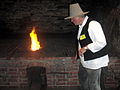
 Schmiedefeuer im Freibergsdorfer Hammer.JPG 2,048 × 1,366; 409 KB


.jpg)


