Category:Freystrop (community)
Media in category "Freystrop (community)"
The following 21 files are in this category, out of 21 total.
-
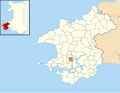
 2010 Wales Pembrokeshire Community Freystrop map.svg 512 × 393; 1,018 KB
-
 2024 Wales Pembrokeshire Community Freystrop map.svg 512 × 393; 1.19 MB
-
 Bridle path - geograph.org.uk - 855990.jpg 640 × 480; 122 KB
-
 Bridleway, Maddox Moor - geograph.org.uk - 220622.jpg 640 × 480; 92 KB
-
 Camouflaged fingerpost - geograph.org.uk - 944064.jpg 640 × 480; 129 KB
-
 Entrance to Pencaer farm - geograph.org.uk - 855986.jpg 640 × 480; 120 KB
-
 Golf course and driving range - geograph.org.uk - 855997.jpg 640 × 480; 89 KB
-
 Little Milford on the West Cleddau - geograph.org.uk - 844364.jpg 640 × 480; 84 KB
-
 Little Milford Wood near Freystrop (8507).jpg 4,288 × 2,848; 6.03 MB
-
 Looking up the Western Cleddau - geograph.org.uk - 944052.jpg 640 × 480; 56 KB
-
 Main Road, Maddox Moor - geograph.org.uk - 1416706.jpg 640 × 480; 173 KB
-
 Puddleduck Bridge, old and new - geograph.org.uk - 775670.jpg 640 × 477; 90 KB
-
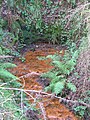 Stumpy Adit - geograph.org.uk - 408543.jpg 482 × 640; 152 KB
-
 The approach to Thornbush Farm - geograph.org.uk - 220573.jpg 640 × 480; 109 KB
-

-
 Western Cleddau - Upper reaches - geograph.org.uk - 803577.jpg 640 × 480; 92 KB
-
 Western Cleddau near Freystrop (8509).jpg 4,288 × 2,848; 5.6 MB
-
 Western Cleddau near Freystrop (8511).jpg 4,288 × 2,848; 6.4 MB
-
 Western Cleddau near Freystrop (8530).jpg 4,288 × 2,848; 6.19 MB
-
 Western Cleddau near Freystrop (8536).jpg 4,288 × 2,848; 6.53 MB
-
 Old Windlass - geograph.org.uk - 342013.jpg 640 × 482; 156 KB


.jpg)


.jpg)
.jpg)
.jpg)
.jpg)
