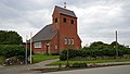
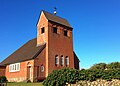
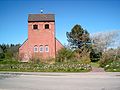
Category:Friesenkapelle (Wenningstedt)
| Object location | | View all coordinates using: OpenStreetMap |
|---|
Chuch building in Schleswig-Holstein state, Germany   | |||||
| Upload media | |||||
| Instance of | |||||
|---|---|---|---|---|---|
| Location | Wenningstedt-Braderup, Landschaft Sylt, Nordfriesland district, Schleswig-Holstein, Germany | ||||
| Street address |
| ||||
| Heritage designation | |||||
 | |||||
Subcategories
This category has the following 2 subcategories, out of 2 total.
Media in category "Friesenkapelle (Wenningstedt)"
The following 10 files are in this category, out of 10 total.
-
 20231019 xl 1439-Friesenkapelle Wenningstedt 2.jpg 3,072 × 4,080; 4.49 MB
-
 20231019 xl 1439-Friesenkapelle Wenningstedt.jpg 3,072 × 4,080; 4.12 MB
-
 Die Springerin 2293.jpg 5,860 × 3,906; 3.4 MB
-
 Friesenkapelle Wennigstedt Sylt@20180914 (1).JPG 3,449 × 2,495; 5.53 MB
-
 Friesenkapelle-Wenningstedt-Sylt.jpg 4,032 × 3,024; 1.64 MB
-
 Friesenkapelle.jpg 6,000 × 3,376; 16.5 MB
-
 Friesenkappelle Wenningstedt.jpg 3,612 × 2,580; 2 MB
-
 Kirche Weningstedt 1.jpg 2,048 × 1,536; 881 KB
-
 Wenningstedt church.jpg 1,704 × 2,272; 1.6 MB
-
 Wenningstedt-Braderup-Friesenkapelle-1953-08-29.jpg 2,575 × 2,575; 1.01 MB


.JPG)


