Category:Gainford, County Durham
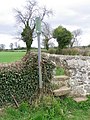
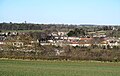
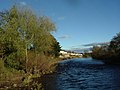
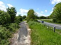
English: Gainford on Tees is a village on the north bank of the River Tees in County Durham, England. It is half-way between Barnard Castle and Darlington, near Winston, at OS map reference NZ 1716.
village in the United Kingdom  | |||||
| Upload media | |||||
| Instance of | |||||
|---|---|---|---|---|---|
| Location | County Durham, North East England, England | ||||
 | |||||
Subcategories
This category has the following 10 subcategories, out of 10 total.
A
- Alwent (5 F)
C
- Gainford C.E. Primary School (2 F)
G
- Gainford railway station (3 F)
- Gainford War Memorial (3 F)
H
- Gainford Hall (4 F)
M
Media in category "Gainford, County Durham"
The following 200 files are in this category, out of 200 total.
-
 'Street Party' for the Royal Wedding - geograph.org.uk - 2389401.jpg 1,303 × 971; 500 KB
-
 A corner of Gainford village green - geograph.org.uk - 6159835.jpg 640 × 480; 119 KB
-
 A farmers bridge also carrying a public footpath at Alwent - geograph.org.uk - 2993669.jpg 3,648 × 2,736; 1.57 MB
-
 A glimpse of the river - geograph.org.uk - 5581393.jpg 3,239 × 4,319; 4.53 MB
-
 A glimpse of the Tees - geograph.org.uk - 5581381.jpg 3,240 × 4,320; 5.02 MB
-
 A house front door - geograph.org.uk - 3418079.jpg 1,368 × 1,824; 905 KB
-
 A house on Low Road, Gainford - geograph.org.uk - 3423667.jpg 1,803 × 882; 553 KB
-

-
 A paddock with spring flowers - geograph.org.uk - 3424920.jpg 1,824 × 1,368; 977 KB
-
 A view north from the Teesdale Way - geograph.org.uk - 1580121.jpg 640 × 480; 84 KB
-
 A young tree plantation south of Alwent - geograph.org.uk - 2993657.jpg 3,648 × 2,736; 2.01 MB
-
 A67 approaching Gainsford - geograph.org.uk - 4731620.jpg 640 × 480; 60 KB
-
 A67 near Gainford - geograph.org.uk - 5194642.jpg 640 × 480; 56 KB
-
 A67 towards Barnard Castle - geograph.org.uk - 4731626.jpg 640 × 480; 88 KB
-
 Access to Gainford Catholic Church - geograph.org.uk - 1516874.jpg 640 × 480; 76 KB
-
 Across the Tees near Wood House - geograph.org.uk - 5581678.jpg 4,320 × 3,240; 4.45 MB
-
 Alwent - geograph.org.uk - 2583500.jpg 3,408 × 2,346; 974 KB
-
 Alwent - geograph.org.uk - 2583529.jpg 3,888 × 2,592; 1.53 MB
-
 Alwent Hall - geograph.org.uk - 3012959.jpg 640 × 480; 71 KB
-
 Alwent Mill - geograph.org.uk - 3379828.jpg 3,740 × 1,920; 1.26 MB
-
 An outhouse area, Edlestone Hall - geograph.org.uk - 3425064.jpg 1,557 × 1,327; 772 KB
-
 B6274 - geograph.org.uk - 2583504.jpg 3,888 × 2,520; 1.35 MB
-
 Blakely Hill Farm - geograph.org.uk - 1339364.jpg 640 × 480; 118 KB
-
 Blakely Hill Farm - geograph.org.uk - 2736821.jpg 3,648 × 2,736; 1.61 MB
-
 Bluebell (Endymion non-scriptus) - geograph.org.uk - 2448875.jpg 480 × 640; 111 KB
-

-
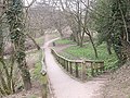
 Bridleway near Gainford - geograph.org.uk - 2453434.jpg 640 × 481; 78 KB
-
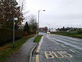 Bus stop on the A67, Gainford - geograph.org.uk - 4734369.jpg 640 × 480; 74 KB
-
 Bus stop, Snow Hall - geograph.org.uk - 4734365.jpg 640 × 467; 102 KB
-
 Café on High Green, Gainford - geograph.org.uk - 2199642.jpg 2,636 × 2,186; 2.28 MB
-
 Cock Lane near Headlam - geograph.org.uk - 2739317.jpg 3,648 × 2,736; 2.66 MB
-
 Dawson's Court, Gainford - geograph.org.uk - 1516882.jpg 640 × 480; 84 KB
-
 Disused Railway Bridge near Gainford - geograph.org.uk - 75616.jpg 640 × 427; 152 KB
-
 Drive to Hollin Hall West - geograph.org.uk - 2453365.jpg 640 × 480; 81 KB
-
 Dyance, Gainford - geograph.org.uk - 6137525.jpg 1,024 × 768; 191 KB
-
 Early autumn foliage on The Green - geograph.org.uk - 1513751.jpg 480 × 640; 75 KB
-
 East end of Gainford - geograph.org.uk - 5194659.jpg 640 × 480; 67 KB
-
 East end of Gainford Green - geograph.org.uk - 5578378.jpg 4,000 × 2,576; 2.74 MB
-
 Eastern end of Gainford Village Green - geograph.org.uk - 2885091.jpg 3,648 × 2,736; 2.88 MB
-
 Edlestone Hall - geograph.org.uk - 459167.jpg 640 × 480; 91 KB
-
 Entering Gainford - geograph.org.uk - 1577190.jpg 640 × 480; 84 KB
-
 Entering Gainford - geograph.org.uk - 5194647.jpg 640 × 480; 44 KB
-
 Entrance to Gainford Cemetery - geograph.org.uk - 458627.jpg 480 × 640; 81 KB
-
 Entrance to The Academy Theatre - geograph.org.uk - 3423557.jpg 1,368 × 1,824; 937 KB
-
 Entrance to Waters End, Gainford - geograph.org.uk - 3423300.jpg 1,699 × 1,297; 544 KB
-
 Farmland, Gainford - geograph.org.uk - 6137523.jpg 1,024 × 768; 298 KB
-
 Farmland, Gainford - geograph.org.uk - 6137526.jpg 1,024 × 768; 248 KB
-
 Farmland, Gainford - geograph.org.uk - 6137528.jpg 1,024 × 768; 306 KB
-
 Farmland, Gainford - geograph.org.uk - 6137543.jpg 1,024 × 768; 225 KB
-
 Farmland, Gainford - geograph.org.uk - 6137545.jpg 1,024 × 768; 261 KB
-

-
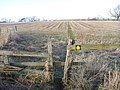
 Field entrance off the A67 - geograph.org.uk - 4731623.jpg 640 × 418; 62 KB
-
 Field entrance off the A67 - geograph.org.uk - 4734367.jpg 640 × 480; 49 KB
-
 Footpath near Gainford - geograph.org.uk - 2453411.jpg 480 × 640; 82 KB
-
 Footpath near Gainford - geograph.org.uk - 2453419.jpg 640 × 480; 69 KB
-
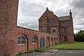
 Former orphanage - geograph.org.uk - 6159846.jpg 640 × 480; 116 KB
-
 Former Poor Law School, Gainford - geograph.org.uk - 1580107.jpg 640 × 480; 103 KB
-
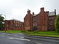 Former St Peter's School, Gainford - geograph.org.uk - 2576664.jpg 640 × 480; 120 KB
-
 Former St. Peter's School - geograph.org.uk - 881872.jpg 640 × 427; 203 KB
-
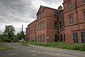 Former St. Peter's School - geograph.org.uk - 882220.jpg 640 × 427; 208 KB
-
 Front Door furniture - geograph.org.uk - 3423971.jpg 1,368 × 1,824; 902 KB
-
 Frontage of the former Gainford Academy - geograph.org.uk - 3423577.jpg 1,368 × 1,824; 752 KB
-
 Gainford - geograph.org.uk - 6036679.jpg 4,320 × 2,730; 2.46 MB
-
 Gainford Bridge - geograph.org.uk - 1937516.jpg 800 × 600; 95 KB
-
 Gainford butchers' shop window - geograph.org.uk - 1513833.jpg 640 × 534; 95 KB
-
 Gainford Great Wood - geograph.org.uk - 1577184.jpg 640 × 480; 44 KB
-
 Gainford Hall - geograph.org.uk - 6036830.jpg 4,320 × 3,240; 1.44 MB
-
 Gainford Hall garden - geograph.org.uk - 3423742.jpg 1,824 × 1,368; 1.19 MB
-
 Gainford Hall, south elevation - geograph.org.uk - 5576895.jpg 3,870 × 2,464; 2.13 MB
-
 Gainford Post Office, County Durham.jpg 2,560 × 1,920; 4.11 MB
-
 Gainford Railway Bridge - geograph.org.uk - 951170.jpg 640 × 402; 101 KB
-
 Gainford Riverside Sun Clock - geograph.org.uk - 3424087.jpg 1,368 × 1,824; 1.39 MB
-
 Gainford Spa - geograph.org.uk - 6159813.jpg 640 × 480; 171 KB
-
 Gainford Spa - geograph.org.uk - 6159816.jpg 640 × 480; 166 KB
-
 Gainford Spa - geograph.org.uk - 6159822.jpg 640 × 480; 177 KB
-
 Gainford Spa fountain - geograph.org.uk - 1744482.jpg 480 × 640; 129 KB
-
 Gainford Stone Cross - geograph.org.uk - 1513765.jpg 640 × 473; 59 KB
-
 Gainford village green - geograph.org.uk - 256138.jpg 640 × 480; 89 KB
-
 Gainford village green - geograph.org.uk - 5800798.jpg 4,320 × 2,025; 1.94 MB
-
 Gainford Village Green - geograph.org.uk - 75697.jpg 640 × 427; 143 KB
-
 Gainford Village Hall - geograph.org.uk - 1516886.jpg 640 × 480; 49 KB
-
 Gainford. - geograph.org.uk - 148071.jpg 640 × 479; 105 KB
-
 Grazing near Gainsford Hall - geograph.org.uk - 4731619.jpg 640 × 480; 56 KB
-
 High Row, Gainford - geograph.org.uk - 1577195.jpg 640 × 480; 104 KB
-
 High Row, Gainford - geograph.org.uk - 3423723.jpg 1,368 × 1,824; 860 KB
-
 High Row, Gainford - geograph.org.uk - 6159792.jpg 640 × 480; 104 KB
-
 High water on the Tees - geograph.org.uk - 5576901.jpg 3,909 × 2,933; 3.37 MB
-
 Horses at Burn House Farm - geograph.org.uk - 1339311.jpg 640 × 480; 89 KB
-
 House at NW corner of The Green at Gainford - geograph.org.uk - 3424051.jpg 1,824 × 1,368; 833 KB
-
 Houses on High Row - geograph.org.uk - 1513756.jpg 640 × 480; 68 KB
-
 Houses on Main Street, Gainford - geograph.org.uk - 1516879.jpg 640 × 480; 40 KB
-
 Jubilee cross, Gainford - geograph.org.uk - 5578392.jpg 3,000 × 3,468; 3.99 MB
-
 Junction of Low Road with High Row - geograph.org.uk - 3423735.jpg 1,824 × 1,368; 817 KB
-
 Leaving Gainford on A67 - geograph.org.uk - 1516895.jpg 640 × 480; 66 KB
-
 Looking upstream River Tees - geograph.org.uk - 459172.jpg 640 × 480; 73 KB
-
 Low Green corner, Gainford - geograph.org.uk - 3424034.jpg 1,824 × 1,368; 838 KB
-
 Low Green, Gainford - geograph.org.uk - 3417987.jpg 1,368 × 1,824; 986 KB
-
 Memorial plaques at Gainford Spa - geograph.org.uk - 1744473.jpg 640 × 480; 122 KB
-
 Methodist Church, Gainford - geograph.org.uk - 256135.jpg 640 × 480; 67 KB
-
 Millennium Sunclock directions - geograph.org.uk - 3424096.jpg 1,368 × 1,824; 980 KB
-
 Mobile library near Gainford - geograph.org.uk - 2453005.jpg 640 × 480; 61 KB
-
 New build near Gainford Bridge - geograph.org.uk - 6159829.jpg 640 × 480; 136 KB
-

-
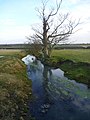
 No access - geograph.org.uk - 5581397.jpg 3,240 × 4,320; 5.27 MB
-
 North Lane, Gainford - geograph.org.uk - 1577204.jpg 640 × 480; 95 KB
-
 Notice at access to Riverside Path, Gainford - geograph.org.uk - 3425098.jpg 1,368 × 1,824; 1.09 MB
-
 Number one, Piggy Lane - geograph.org.uk - 3423694.jpg 1,824 × 1,368; 927 KB
-

-
 On High Row, Gainford - geograph.org.uk - 1513761.jpg 640 × 480; 72 KB
-
 Ordnance Survey benchmark - geograph.org.uk - 3424128.jpg 1,824 × 1,368; 1.34 MB
-
 Park Farm - geograph.org.uk - 882221.jpg 640 × 427; 196 KB
-
-
 Path signpost by A67 - geograph.org.uk - 1744523.jpg 480 × 640; 85 KB
-
 Path to Gainford Spa fountain - geograph.org.uk - 1744459.jpg 480 × 640; 158 KB
-
 Pride comes before a fall - 2 - geograph.org.uk - 1340014.jpg 640 × 480; 125 KB
-

-

-

-
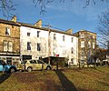
 Remains of the former orphanage, Gainford - geograph.org.uk - 5581366.jpg 3,806 × 2,889; 2.37 MB
-
 Resting place by Gainford Spa - geograph.org.uk - 1744467.jpg 640 × 480; 148 KB
-
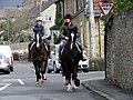 Riding through Gainford - geograph.org.uk - 2452239.jpg 640 × 481; 98 KB
-
 River Tees - geograph.org.uk - 6160634.jpg 640 × 480; 141 KB
-
 River Tees at Gainford - geograph.org.uk - 256117.jpg 640 × 480; 92 KB
-
 River Tees, Gainford - geograph.org.uk - 2448688.jpg 640 × 480; 71 KB
-
 River Tees, Gainford - geograph.org.uk - 2448747.jpg 640 × 480; 67 KB
-
 River Tees, Gainford - geograph.org.uk - 2448758.jpg 640 × 480; 71 KB
-
 Road and a busy field, Gainford - geograph.org.uk - 6137521.jpg 1,024 × 768; 302 KB
-
 Road from Selaby Hall - geograph.org.uk - 1515073.jpg 640 × 484; 103 KB
-
 Robins Pincushion - geograph.org.uk - 952315.jpg 640 × 480; 68 KB
-
 Rook nests on Low Green, Gainford - geograph.org.uk - 3417981.jpg 1,368 × 1,824; 1.18 MB
-
 School building, Gainford - geograph.org.uk - 6159801.jpg 640 × 480; 114 KB
-
 Selaby Basses - geograph.org.uk - 1514373.jpg 640 × 480; 79 KB
-
 Selaby Farm - geograph.org.uk - 3752355.jpg 2,432 × 1,904; 1.04 MB
-
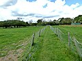
 Sheep pasture near Gainford - geograph.org.uk - 5581385.jpg 4,320 × 3,240; 6.84 MB
-
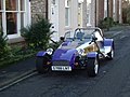 Shiny blue roadster - geograph.org.uk - 256145.jpg 640 × 480; 84 KB
-
 Site of St Mary's Well - geograph.org.uk - 256118.jpg 640 × 480; 154 KB
-
 Snow Hall - geograph.org.uk - 6160626.jpg 640 × 480; 136 KB
-
 Snow Hall Open Gardens Summer 2007 - geograph.org.uk - 749530.jpg 640 × 480; 107 KB
-
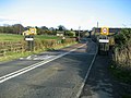
 Spa Road (A67), Gainsford - geograph.org.uk - 4731622.jpg 640 × 480; 53 KB
-
 Spring, Gainford - geograph.org.uk - 2448846.jpg 640 × 480; 107 KB
-
 St.Peter's , Gainford. - geograph.org.uk - 190553.jpg 640 × 376; 112 KB
-
 Steps and ramp to the Riverside Path - geograph.org.uk - 3425104.jpg 1,824 × 1,368; 1.12 MB
-
 Stile on footpath from Westholme to Alwent - geograph.org.uk - 3379760.jpg 4,320 × 3,240; 5.85 MB
-

-
 Stream under B6274 at Alwent - geograph.org.uk - 3379848.jpg 3,240 × 4,320; 1.59 MB
-
 Subway under the old railway - geograph.org.uk - 5194671.jpg 640 × 480; 138 KB
-
 Sunclock markings - geograph.org.uk - 3424109.jpg 1,824 × 1,368; 960 KB
-
 Tees below Gainford - geograph.org.uk - 1197012.jpg 640 × 480; 108 KB
-
 Teesdale Way - geograph.org.uk - 5194686.jpg 640 × 480; 110 KB
-
 Teesdale Way - geograph.org.uk - 6160229.jpg 640 × 480; 118 KB
-
 Teesdale Way beside the A67 - geograph.org.uk - 6159785.jpg 640 × 480; 143 KB
-

-
 Teesdale Way near Snow Hall - geograph.org.uk - 6160225.jpg 640 × 480; 156 KB
-
 Teeside Way path junction - geograph.org.uk - 1744522.jpg 640 × 480; 168 KB
-
 Terrace in Gainford - geograph.org.uk - 5578375.jpg 3,000 × 3,527; 2.1 MB
-
 Terraced houses on The Green in Gainford - geograph.org.uk - 3418045.jpg 1,824 × 1,368; 870 KB
-
 The A67 leaving Gainford to the east - geograph.org.uk - 1850776.jpg 640 × 481; 101 KB
-
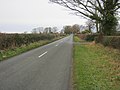
 The A67 westwards nearing Gainford - geograph.org.uk - 2893826.jpg 2,334 × 1,751; 1,009 KB
-
 The Academy Theatre, Gainford - geograph.org.uk - 2018449.jpg 972 × 1,296; 391 KB
-
 The Academy Theatre, Gainford - geograph.org.uk - 3423336.jpg 1,368 × 1,824; 897 KB
-
 The Coach House, Low Road - geograph.org.uk - 3423961.jpg 1,824 × 1,368; 921 KB
-
 The Corner Shop - geograph.org.uk - 1513828.jpg 640 × 448; 71 KB
-
 The Green, Gainford - geograph.org.uk - 2199651.jpg 3,648 × 2,736; 4.38 MB
-
 The Green, Gainford - geograph.org.uk - 2448363.jpg 640 × 480; 66 KB
-
 The Green, Gainford - geograph.org.uk - 5578383.jpg 4,000 × 2,539; 2.97 MB
-
 The Laurels Coffee Shop in Gainford - geograph.org.uk - 3423660.jpg 1,824 × 1,368; 801 KB
-
 The Lord Nelson pub - geograph.org.uk - 1516890.jpg 640 × 480; 49 KB
-
 The Spa at Gainford - geograph.org.uk - 75594.jpg 640 × 427; 159 KB
-
 The Tees at Gainford - geograph.org.uk - 5576898.jpg 3,931 × 2,565; 2.46 MB
-
 The Tees between Gainford and Piercebridge - geograph.org.uk - 5581671.jpg 3,962 × 2,791; 4.02 MB
-
 The Teesdale Way in Gainford - geograph.org.uk - 1580096.jpg 640 × 480; 79 KB
-
 The Teesdale Way leaving the A67 - geograph.org.uk - 2893847.jpg 3,648 × 2,736; 3.04 MB
-
 The Teesdale Way passes under the old railway - geograph.org.uk - 5581374.jpg 3,240 × 4,320; 3.63 MB
-
 The Vicarage gateway - geograph.org.uk - 3417994.jpg 1,824 × 1,368; 944 KB
-
 Toll Gate Cottage - geograph.org.uk - 2583519.jpg 3,839 × 2,517; 1.34 MB
-
 Toll Gate Cottage next to the B6274 - geograph.org.uk - 2894501.jpg 3,648 × 2,736; 2.42 MB
-
 Track to Selaby Farm - geograph.org.uk - 3379837.jpg 4,320 × 3,240; 5.44 MB
-
 Two 3-storey houses on 'The Green' in Gainford - geograph.org.uk - 3418037.jpg 1,824 × 1,368; 970 KB
-
 Upstream from Gainford Railway Bridge - geograph.org.uk - 952309.jpg 640 × 480; 103 KB
-
 View from above Langley Beck - geograph.org.uk - 1577173.jpg 640 × 480; 97 KB
-
-
 Village green at Gainford - geograph.org.uk - 3655686.jpg 640 × 427; 102 KB
-
 Village Green in Gainford - geograph.org.uk - 1577198.jpg 640 × 480; 93 KB
-
 Village green, Gainford - geograph.org.uk - 2576672.jpg 640 × 480; 131 KB
-
 Village Green, Gainford, County Durham.jpg 2,560 × 1,920; 3.94 MB
-
 Village sign, Gainford - geograph.org.uk - 6160223.jpg 480 × 640; 144 KB
-
 Water End - geograph.org.uk - 1744536.jpg 640 × 576; 104 KB
-
 Weather vane, Gainford - geograph.org.uk - 2452232.jpg 640 × 481; 52 KB
-
 Wesleyan Methodist Chapel - geograph.org.uk - 3424070.jpg 1,749 × 1,213; 777 KB
-
 Wesleyan Sunday School, Gainford - geograph.org.uk - 3424064.jpg 1,824 × 1,368; 964 KB
-
 Winstonberry Cafe - geograph.org.uk - 6159840.jpg 640 × 480; 121 KB
-
 A bridge over the Tees in Gainford - geograph.org.uk - 459175.jpg 640 × 480; 121 KB
-
 Barforth Bridge over the Tees - geograph.org.uk - 459171.jpg 640 × 480; 88 KB
-
 Bay-windowed houses on High Row - geograph.org.uk - 1513838.jpg 549 × 640; 89 KB
-
 Cattle grid - geograph.org.uk - 458613.jpg 640 × 480; 58 KB
-
 End of metalled section of Boat Lane. - geograph.org.uk - 459494.jpg 640 × 480; 117 KB
-
 Gainford Riverside Millennium Green - geograph.org.uk - 458625.jpg 480 × 640; 117 KB
-
 Gainford west end - geograph.org.uk - 459480.jpg 640 × 480; 113 KB
-
 High Road, Gainford - geograph.org.uk - 459046.jpg 640 × 480; 87 KB
-


_-_geograph.org.uk_-_2448875.jpg)


.jpg)


_-_geograph.org.uk_-_1514387.jpg)


,_Gainsford_-_geograph.org.uk_-_4731622.jpg)


