Category:Gamerschestraat 41, Zaltbommel
| Object location | | View all coordinates using: OpenStreetMap |
|---|
 | |||||
| Upload media | |||||
| Instance of |
| ||||
|---|---|---|---|---|---|
| Location | Zaltbommel, Gelderland, Netherlands | ||||
| Street address |
| ||||
| Heritage designation |
| ||||
 | |||||
|
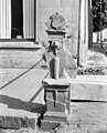
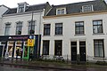
This is a category about rijksmonument number 40140
|
| Address |
|
Media in category "Gamerschestraat 41, Zaltbommel"
The following 5 files are in this category, out of 5 total.
-
 Gamerschstraat 41.jpg 4,000 × 3,000; 800 KB
-
 Hoek Karrestraat, stoeppaal - Zaltbommel - 20220311 - RCE.jpg 966 × 1,200; 256 KB
-
 Hoek Karstraat - Zaltbommel - 20220336 - RCE.jpg 1,200 × 807; 210 KB
-
 Pand Gamerschestraat Zaltbommel P1120625.jpg 4,000 × 2,672; 4.71 MB
-
 Panden Gamerschestraat P1120627.jpg 4,000 × 2,672; 5.53 MB


