Category:Gare de Longwy
| Object location | | View all coordinates using: OpenStreetMap |
|---|
railway station in France  | |||||
| Upload media | |||||
| Instance of | |||||
|---|---|---|---|---|---|
| Location | Longwy, Meurthe-et-Moselle, Grand Est, Metropolitan France, France | ||||
| Street address |
| ||||
| Transport network | |||||
| Owned by | |||||
| Operator | |||||
| Date of official opening |
| ||||
| Elevation above sea level |
| ||||
| Connecting line | |||||
| Adjacent station | |||||
 | |||||
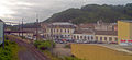
Français : La gare de Longwy est une gare ferroviaire française de la ligne de Longuyon à Mont-Saint-Martin (vers Athus), située sur le territoire de la commune de Longwy dans le département de Meurthe-et-Moselle en région Lorraine.
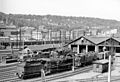
Media in category "Gare de Longwy"
The following 6 files are in this category, out of 6 total.
-
 03.09.89 Longwy CFL 3607 (6287388394).jpg 1,483 × 945; 304 KB
-
 Bahnhof Longwy.jpg 2,907 × 1,334; 3.03 MB
-
 Bahnhofvorplatz Longwy.jpg 7,599 × 1,885; 4.09 MB
-
 France Rail 044 Longwy.jpg 2,302 × 1,575; 1.63 MB
-

-
 隆维火车站.jpg 4,032 × 3,024; 2.96 MB
.jpg)

