Category:Gare de Saint-Cyr-en-Val
| Object location | | View all coordinates using: OpenStreetMap |
|---|
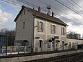
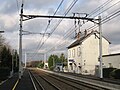
railway station in Saint-Cyr-en-Val, France  | |||||
| Upload media | |||||
| Instance of | |||||
|---|---|---|---|---|---|
| Location | Saint-Cyr-en-Val, Loiret, Centre-Val de Loire, Metropolitan France, France | ||||
| Transport network | |||||
| Owned by | |||||
| Operator | |||||
| Date of official opening |
| ||||
| Elevation above sea level |
| ||||
| Connecting line | |||||
| Adjacent station | |||||
 | |||||
Français : La gare de Saint-Cyr-en-Val est une gare ferroviaire de la ligne des Aubrais - Orléans à Montauban-Ville-Bourbon, située sur le territoire de la commune française de Saint-Cyr-en-Val, dans le département du Loiret, en région Centre.
Media in category "Gare de Saint-Cyr-en-Val"
The following 7 files are in this category, out of 7 total.
-
 Gare St Cyr en Val.JPG 3,264 × 2,448; 1.45 MB
-
 Saint-Cyr-en-Val gare 1.jpg 3,264 × 2,448; 1.46 MB
-
 Saint-Cyr-en-Val gare 2.jpg 3,264 × 2,448; 1.83 MB
-
 Saint-Cyr-en-Val gare 3.jpg 3,264 × 2,448; 1.77 MB
-
 Saint-Cyr-en-Val gare 4.jpg 3,264 × 2,448; 1.5 MB
-
 St Cyr Gare.JPG 3,264 × 2,448; 1.47 MB
-
 Un ter en gare de Saint-Cyr-en-Val.jpg 1,168 × 880; 514 KB


