Category:Gates in Falkirk council area
Media in category "Gates in Falkirk council area"
The following 19 files are in this category, out of 19 total.
-
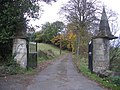
 Access to Bonhard Place - geograph.org.uk - 640976.jpg 640 × 480; 93 KB
-
 Blackness House - geograph.org.uk - 641483.jpg 640 × 480; 129 KB
-
 Braes driveway - geograph.org.uk - 273490.jpg 640 × 480; 138 KB
-
 Caravan retailers - geograph.org.uk - 180310.jpg 640 × 480; 64 KB
-

-
 Easter Drumclair... gone west. - geograph.org.uk - 402301.jpg 640 × 480; 86 KB
-
 Entrance to Old Parish Churchyard (geograph 7009617).jpg 1,158 × 868; 278 KB
-
 Entrance to playing fields - geograph.org.uk - 1122508.jpg 640 × 480; 73 KB
-
 Fortified manor house. - geograph.org.uk - 85263.jpg 640 × 480; 109 KB
-
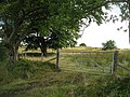
 Gate and field - geograph.org.uk - 1351634.jpg 640 × 480; 91 KB
-
 Gate near Easter Greenrig - geograph.org.uk - 990747.jpg 640 × 480; 44 KB
-
 Gateway into Forest on Denny Muir - geograph.org.uk - 259296.jpg 640 × 480; 162 KB
-

-
 Muiravonside. - geograph.org.uk - 85333.jpg 625 × 452; 68 KB
-
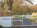
 Old Burnshot - geograph.org.uk - 641633.jpg 640 × 480; 99 KB
-
 Railway Bridge - geograph.org.uk - 541038.jpg 640 × 426; 97 KB
-
 Rough grazing, Auchengean - geograph.org.uk - 1461662.jpg 640 × 480; 129 KB
-
 Side door to the railway - geograph.org.uk - 552360.jpg 640 × 480; 53 KB
-
 Track gate - geograph.org.uk - 988525.jpg 640 × 480; 90 KB


.jpg)


