Category:Gemeenteweg 308, Staphorst
| Object location | | View all coordinates using: OpenStreetMap |
|---|
 | |||||
| Upload media | |||||
| Instance of | |||||
|---|---|---|---|---|---|
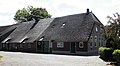
| Location | Staphorst, Overijssel, Netherlands | ||||
| Street address |
| ||||
| Located on street |
| ||||
| Heritage designation |
| ||||
 | |||||
|
This is a category about rijksmonument number 34272
|
| Address |
|
Media in category "Gemeenteweg 308, Staphorst"
The following 4 files are in this category, out of 4 total.
-
 Aanzicht - IJhorst - 20119223 - RCE.jpg 1,200 × 811; 258 KB
-
 Linker zij- en achtergevel - Staphorst - 20204242 - RCE.jpg 1,188 × 1,200; 365 KB
-
 Staphorst - Gemeenteweg 308 RM34272.JPG 4,539 × 2,500; 1.37 MB
-
 Voor- en linker zijgevel - Staphorst - 20204241 - RCE.jpg 1,190 × 1,200; 329 KB


