Category:Gentsestraat 18, Hulst
| Object location | | View all coordinates using: OpenStreetMap |
|---|
 | |||||
| Upload media | |||||
| Instance of |
| ||||
|---|---|---|---|---|---|
| Location | Hulst, Zeeland, Netherlands | ||||
| Street address |
| ||||
| Located on street | |||||
| Heritage designation |
| ||||
 | |||||
|
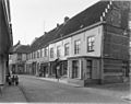
This is a category about rijksmonument number 22746
|
| Address |
|
Media in category "Gentsestraat 18, Hulst"
The following 6 files are in this category, out of 6 total.
-
 Gentsestr. exterieur - Hulst - 20118765 - RCE.jpg 948 × 1,200; 227 KB
-
 Gentsestr. exterieur - Hulst - 20118766 - RCE.jpg 1,200 × 953; 233 KB
-
 Gentsestr. exterieur - Hulst - 20118767 - RCE.jpg 1,200 × 942; 222 KB
-
 Hulst - rijksmonument 22746 - Gentsestraat 18 20120714.jpg 559 × 800; 203 KB
-
 Overzicht - Hulst - 20118783 - RCE.jpg 1,200 × 808; 220 KB
-
 Voor- en zijgevel - Hulst - 20118794 - RCE.jpg 817 × 1,200; 215 KB


