Category:Geographic information systems
spatial data information systems  Map by John Snow in 1854; cholera cases highlighted in black  | |||||
| Upload media | |||||
| Pronunciation audio | |||||
|---|---|---|---|---|---|
| Instance of |
| ||||
| Subclass of | |||||
| Has use |
| ||||
| Inception |
| ||||
| Different from | |||||
| |||||
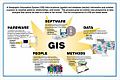
A geographic information system (GIS), also known as a geographical information system, is an information system for capturing, storing, analyzing, managing and presenting data which is spatially referenced (linked to location).
Subcategories
This category has the following 24 subcategories, out of 24 total.
3
- 3D city models (27 F)
A
- Atlas okolja (3 F)
D
- DE-9IM (11 F)
G
- Geonames (11 F)
- GeoSUR (3 F)
- GIS promo image (1 F)
N
- NEXRAD network maps (6 F)
R
S
- Simple feature access (9 F)
W
- Web Map Tile Service (1 F)
Media in category "Geographic information systems"
The following 200 files are in this category, out of 292 total.
(previous page) (next page)-
 2023-05-13 Augusta Raurica TOT 058.jpg 6,000 × 4,000; 6.29 MB
-
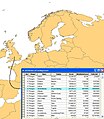
 Adlinterface.png 900 × 633; 113 KB
-
 Alagoas Geográfico.png 944 × 465; 237 KB
-
 Algoritmo Radial. Sumatoria radial de ángulos.png 362 × 287; 15 KB
-
 AlkadiPicture.jpg 773 × 1,024; 39 KB
-
 All findspots mapped from 2003 onwards.jpg 632 × 626; 350 KB
-
 All findspots mapped up until 2003.jpg 622 × 620; 142 KB
-
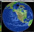 ALPS Globe.jpg 1,000 × 942; 803 KB
-
 An Geomatist.jpg 3,648 × 2,736; 3.22 MB
-
 Arizona-Roads-GIS.png 10,000 × 10,000; 29.31 MB
-
 ASCII grid example.svg 210 × 330; 3 KB
-
 Austin Texas LiDAR Point Cloud (Highway 183).png 1,920 × 780; 2.95 MB
-
 AxiomaGIS.png 652 × 368; 756 KB
-
 Bordeaux–Paris route overlay.svg 220 × 211; 995 bytes
-
 CAA-PRIMARY-LOGO-with-SUBTITLE-RGB website.png 300 × 148; 23 KB
-
 California -- Roads using GIS data.png 10,000 × 10,000; 25.95 MB
-
 CartographyNoLongerKing.svg 1,052 × 744; 58 KB
-
 Check-fil-A and Baptist Church Heat Map.png 3,507 × 2,480; 1.28 MB
-
 City of Minneapolis Street Map (16462765573).jpg 5,760 × 3,840; 10.23 MB
-
 Copernicus 1891-2023.jpg 4,564 × 3,212; 5.49 MB
-
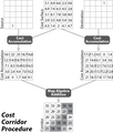 Costcorridor.png 989 × 1,165; 85 KB
-
 Costpath Flowchart.png 989 × 2,065; 133 KB
-
 Coverage encoding variants.png 895 × 298; 27 KB
-
 CreerTerrain.jpg 1,920 × 1,170; 294 KB
-
 Cybergis-roger.jpg 2,048 × 1,536; 570 KB
-
 DatendimensionenImGIS.jpg 1,346 × 350; 58 KB
-
 DG GOGIS and Chairman GOSUPDA.jpg 3,936 × 1,728; 1.72 MB
-
 DGGs-asOGC-topic21-fig1.png 1,200 × 449; 201 KB
-
 Diagrama flujo GIS obra lineal.jpg 1,587 × 1,123; 114 KB
-

-
 Digimap roam.png 250 × 143; 72 KB
-
 Digitizing errors.jpg 2,370 × 2,110; 804 KB
-
 Digitizing errors.svg 210 × 524; 9 KB
-
 DimensionesdelosdatosSIG.jpg 1,346 × 350; 56 KB
-
 Director General of GOGIS and Technical Team 01.jpg 3,936 × 1,728; 2 MB
-
 Director General of GOGIS and Technical Team 02.jpg 3,936 × 1,728; 1.81 MB
-
 Director General of GOGIS and Technical Team 03.jpg 3,936 × 1,728; 1.82 MB
-
 Director General of GOGIS and Technical Team 04.jpg 3,936 × 1,728; 2.01 MB
-
 Director General of GOGIS and Technical Team 05.jpg 3,936 × 1,728; 2.19 MB
-
 Director General of GOGIS and Technical Team 06.jpg 3,936 × 1,728; 2.25 MB
-
 Director General of GOGIS and Technical Team 07.jpg 3,936 × 1,728; 2.23 MB
-
 Director General of GOGIS and Technical Team 08.jpg 3,936 × 1,728; 2.12 MB
-
 Director General of GOGIS and Technical Team 09.jpg 3,936 × 1,728; 2.26 MB
-
 Director General of GOGIS and Technical Team 10.jpg 3,936 × 1,728; 2.19 MB
-
 Director General of GOGIS and Technical Team 11.jpg 3,936 × 1,728; 2.08 MB
-
 Director General of GOGIS and Technical Team 12.jpg 3,936 × 1,728; 1.94 MB
-
 Director General of GOGIS and Technical Team 13.jpg 3,936 × 1,728; 2.21 MB
-
 Director General of GOGIS and Technical Team 14.jpg 3,936 × 1,728; 2.31 MB
-
 Director General of GOGIS and Technical Team 15.jpg 3,936 × 1,728; 2.08 MB
-
 Director General of GOGIS and Technical Team 16.jpg 3,936 × 1,728; 2.01 MB
-
 Director General of GOGIS and Technical Team 17.jpg 3,936 × 1,728; 2.43 MB
-
 Director General of GOGIS and Technical Team 18.jpg 3,936 × 1,728; 2.16 MB
-
 Director General of GOGIS and Technical Team 19.jpg 3,936 × 1,728; 1.68 MB
-
 Director General of GOGIS and Technical Team 20.jpg 3,936 × 1,728; 2.64 MB
-
 Director General of GOGIS and Technical Team 21.jpg 3,936 × 1,728; 2.17 MB
-
 Donut polygonen en topologie voorbeelden.PNG 836 × 752; 56 KB
-
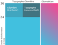 Durée et cursus Topographe-Géomètre et Géomaticien en Allemagne.png 2,560 × 1,977; 293 KB
-
 EditingField.jpg 730 × 382; 54 KB
-
 EFDAC-Map-Viewer-thumbnail.jpg 274 × 170; 18 KB
-
 Eine einfache Landkarte im Vektorformat.svg 250 × 200; 7 KB
-
 Erosiegevoeligheidskartering3.PNG 1,300 × 863; 3.36 MB
-
 Esquema GIS convencional.png 723 × 269; 53 KB
-
 Esquema GIS nuevo.png 723 × 269; 65 KB
-
 Etapes du MNZI.jpg 1,475 × 1,300; 663 KB
-
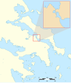 Euripus SWBD demo.svg 1,432 × 1,655; 1.78 MB
-
 Exemple de transformation.jpg 317 × 446; 12 KB
-
 Ferret program.png 768 × 662; 54 KB
-
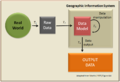 Fig 4.4.png 932 × 640; 67 KB
-
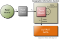 Fig 4.4.svg 878 × 575; 24 KB
-
 Fig soilmap types.pdf 1,754 × 1,239; 38 KB
-
 Fig soilmap types.png 2,147 × 1,388; 50 KB
-
 Fish Movements USGS.JPG 637 × 617; 36 KB
-
 FM Tree Raster Figure 1.jpeg 782 × 752; 199 KB
-
 Gabor en omgeving voorbeeld classificatie puntobjecten legenda items.PNG 1,215 × 529; 94 KB
-
 GBHGIS meta architecture.gif 310 × 218; 9 KB
-
 Geabios3d.jpg 280 × 242; 14 KB
-
 Geo visualisatie met een gis op drie wijzen.PNG 1,157 × 389; 35 KB
-
 Geo visualisatie met een gis op twee wijzen.PNG 1,065 × 510; 32 KB
-
 Geo-portaal-net-niet.PNG 361 × 671; 25 KB
-
 Geo-portaal-wel.PNG 406 × 672; 35 KB
-
 Geoarcut Logo Gris.jpg 388 × 228; 23 KB
-
 GeoBImarket GIS analytical platform. Analysis of geospatial data.png 1,366 × 686; 1.62 MB
-
 Geographic Information System example.jpg 728 × 836; 247 KB
-
 Geomajas screenshot.jpg 1,920 × 1,038; 565 KB
-
 GeoPista.gif 946 × 687; 220 KB
-
 Geoprocessamento Epagri Ciram.JPG 2,304 × 3,072; 2.58 MB
-
 Georefererenstap2.PNG 116 × 152; 3 KB
-
 Geoservices server with apps.png 694 × 569; 44 KB
-
 Geothermische Standorte.gif 1,000 × 665; 124 KB
-
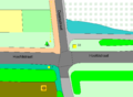
 GIP Detailansicht Wien, Kreuzung Schottenring-Börsegasse.png 1,500 × 911; 715 KB
-
 GIS 2.jpg 702 × 1,202; 605 KB
-
 Gis bestand definities.PNG 948 × 408; 32 KB
-
 GIS de nodos.png 723 × 269; 66 KB
-
 GIS hierarchic model.png 2,040 × 1,600; 111 KB
-
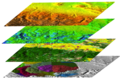 GIS Layers.png 800 × 532; 527 KB
-
 GIS user.svg 807 × 635; 1.03 MB
-
 GIS-bewerkingen afh van projectie.png 1,000 × 263; 602 KB
-
 Gis-data-opslag.PNG 779 × 465; 26 KB
-
 Gis-data-opslag.png 775 × 410; 22 KB
-
 Gis-data-voorbeeld.PNG 1,252 × 917; 49 KB
-
 GIS-definities.PNG 1,211 × 458; 85 KB
-
 Gis-reken-voorbeelden.PNG 1,538 × 390; 56 KB
-
 Gis2.jpg 275 × 183; 11 KB
-
 GISc lex.png 960 × 720; 41 KB
-
 Gislayers.jpg 997 × 657; 300 KB
-
 GisLayers.png 997 × 657; 1.39 MB
-
 Gismodelvoobeeld.PNG 1,033 × 781; 305 KB
-
 Gismodelvoorbeeldtotstandkoming.PNG 1,027 × 956; 431 KB
-
 GISNetworkExample.svg 862 × 295; 38 KB
-
 Global OFG.png 714 × 547; 288 KB
-
 GMT Example 01.jpg 995 × 1,040; 157 KB
-
 GMT Example 02.jpg 1,122 × 1,155; 208 KB
-
 Goede visuele hiërarchie 3D model.PNG 1,121 × 639; 32 KB
-
 GOGIS Receives Staff of Ashaka 01.jpg 3,936 × 1,728; 2.01 MB
-
 GOGIS Receives Staff of Ashaka 02.jpg 3,936 × 1,728; 1.51 MB
-
 GOGIS Receives Staff of Ashaka 03.jpg 3,936 × 1,728; 1.94 MB
-
 GOGIS Receives Staff of Ashaka 04.jpg 3,936 × 1,728; 1.99 MB
-
 GOGIS Receives Staff of Ashaka 05.jpg 3,936 × 1,728; 2.02 MB
-
 GOGIS Receives Staff of Ashaka 06.jpg 3,936 × 1,728; 1.85 MB
-
 GOGIS Receives Staff of Ashaka 07.jpg 3,936 × 1,728; 1.51 MB
-
 GOGIS Receives Staff of Ashaka 08.jpg 3,936 × 1,728; 1.67 MB
-
 GOGIS Receives Staff of Ashaka 09.jpg 3,936 × 1,728; 1.52 MB
-
 GOGIS Receives Staff of Ashaka 10.jpg 3,936 × 1,728; 1.82 MB
-
 GOGIS Receives Staff of Ashaka 11.jpg 3,936 × 1,728; 1.81 MB
-
 GOGIS Receives Staff of Ashaka 12.jpg 3,936 × 1,728; 1.68 MB
-
 GOGIS Receives Staff of Ashaka 13.jpg 3,936 × 1,728; 1.41 MB
-
 GOGIS Receives Staff of Ashaka 14.jpg 3,936 × 1,728; 1.41 MB
-
 GOGIS Receives Staff of Ashaka 15.jpg 3,936 × 1,728; 1.51 MB
-
 GOGIS Receives Staff of Ashaka 16.jpg 3,936 × 1,728; 1.5 MB
-
 GOGIS Receives Staff of Ashaka 17.jpg 3,936 × 1,728; 1.23 MB
-
 GOGIS Receives Staff of Ashaka 18.jpg 3,936 × 1,728; 1.51 MB
-
 GOGIS Receives Staff of Ashaka 19.jpg 3,936 × 1,728; 1.67 MB
-
 GOGIS Receives Staff of Ashaka 20.jpg 3,936 × 1,728; 1.9 MB
-
 GOGIS Receives Staff of Ashaka 21.jpg 3,936 × 1,728; 1.85 MB
-
 GOGIS Receives Staff of Ashaka 22.jpg 3,936 × 1,728; 1.67 MB
-
 GOGIS Receives Staff of Ashaka 23.jpg 3,936 × 1,728; 2.05 MB
-
 GOGIS Receives Staff of Ashaka 24.jpg 3,936 × 1,728; 1.87 MB
-
 GOGIS Receives Staff of Ashaka 25.jpg 3,936 × 1,728; 2.53 MB
-
 GOGIS Receives Staff of Ashaka 26.jpg 3,936 × 1,728; 2.37 MB
-
 GOGIS Receives Staff of Ashaka 27.jpg 3,936 × 1,728; 1.8 MB
-
 GOGIS Receives Staff of Ashaka 28.jpg 3,936 × 1,728; 1.55 MB
-
 GOGIS Receives Staff of Ashaka 29.jpg 1,620 × 711; 853 KB
-
 GOGIS Receives Staff of Ashaka 31.jpg 3,936 × 1,728; 1.77 MB
-
 GOGIS Receives Staff of Ashaka 32.jpg 3,936 × 1,728; 1.71 MB
-
 GOGIS Receives Staff of Ashaka 33.jpg 1,620 × 711; 901 KB
-
 GOGIS Receives Staff of Ashaka 34.jpg 1,620 × 711; 883 KB
-
 GOGIS Receives Staff of Ashaka 35.jpg 3,936 × 1,728; 1.6 MB
-
 GOGIS Receives Staff of Ashaka 36.jpg 3,936 × 1,728; 2.19 MB
-
 Grafische variabelen en hun toepassingemogelijkheden binnen de cartografie.PNG 1,080 × 1,190; 86 KB
-
 Grand-Lake-River.png 2,000 × 1,356; 211 KB
-
 Graphenintegrations-Plattform GIP Österreich.png 1,592 × 941; 1.42 MB
-
 Green Fee Logo.png 730 × 700; 164 KB
-
 GroundTruth processModel01.png 548 × 220; 23 KB
-
 Hellingklassenkaart voorbeeld.jpg 500 × 964; 192 KB
-
 Hetbelangvanbuitengrenzen voorbeeldfiguur.PNG 598 × 1,121; 33 KB
-
 Home Owners' Loan Corp. (HOLC) Neighborhood Redlining Grade in Houston, Texas.png 2,371 × 1,679; 4.05 MB
-
 Horizontalschnitt.png 1,000 × 653; 365 KB
-
 How PostGIS Topology is implemented.svg 690 × 638; 29 KB
-
 Illinois-Roads-GIS.png 6,193 × 10,000; 19.38 MB
-
 Imago3D.jpg 1,088 × 557; 272 KB
-
 Informing biodiversity maps.png 966 × 608; 89 KB
-
 InteroperableIntegrationOfSpatialData.svg 697 × 767; 17 KB
-
 JDTM ZK webportal small.gif 320 × 218; 427 KB
-
 JDTM ZK webportal.gif 1,266 × 864; 5.91 MB
-
 Kaart voorbeelden output formaten.PNG 744 × 852; 186 KB
-
 Kahlenbergrutschung.png 1,293 × 876; 2.14 MB
-
 Keymap SDK Mobile.PNG 286 × 489; 93 KB
-
 Labellen wat wel en wat niet te doen.PNG 645 × 864; 48 KB
-
 LANDFIRE's Fire Regime Group Map.jpg 320 × 207; 23 KB
-
 Lineair Refereren input voorbeeld bestanden A50.PNG 884 × 552; 37 KB
-
 Lineair Refereren output voorbeeld bestanden A50.PNG 1,126 × 567; 37 KB
-
 Locals using Geographic Information System (18256648788).jpg 1,500 × 1,125; 296 KB
-
 Logische Datenstruktur GR.png 889 × 837; 25 KB
-
 Logo CAA 2023.svg 264 × 82; 46 KB
-
 Logo Rt.jpg 152 × 60; 3 KB
-
 Luna en proyección ortográfica.jpg 8,584 × 4,924; 12.49 MB
-
 Map of water sources in Western United States.svg 1,052 × 744; 2.04 MB
-
 Map regression - transcription.svg 1,052 × 744; 71 KB
-
 Mapa de isohipsas 10 m.jpg 5,906 × 5,906; 18.59 MB
-
 MapAlgebra.png 2,406 × 2,051; 188 KB
-
 Maup csr.png 595 × 659; 141 KB
-
 Maup rate numbers.png 970 × 925; 50 KB
-
 Miami OSM Bulk Building Import Potential.png 1,804 × 1,822; 3.29 MB
-
 Mm gaudi curt gisrs.gif 392 × 80; 16 KB
-
 Moiré kandidaat kaart.PNG 663 × 609; 21 KB
-
 Neighborhood graph.png 665 × 660; 16 KB
-
 NetworkType.png 435 × 289; 62 KB
-
 New Jersey-Roads-GIS.png 5,888 × 10,000; 19.3 MB
-
 Objectgericht gekoppeld stap5.PNG 116 × 152; 2 KB
-
 Objectgericht getekend stap4.PNG 116 × 152; 1 KB
-
 Objectgericht tekenen.PNG 1,248 × 855; 32 KB
-
 OGC WCS Suite, Logical Suite.png 1,109 × 861; 55 KB
-
 OGC WCS, trim and slice operations.png 499 × 489; 8 KB
-
 Oklahoma gis.jpg 530 × 410; 47 KB
-
 OpenJUMP-GUI.png 1,018 × 735; 869 KB
-
 OpenStreetMap routing service.png 484 × 490; 93 KB
-
 Opilux-1.png 942 × 672; 1.55 MB
-
 Opilux-2.png 465 × 329; 156 KB
-
 OSM data in OpenJUMP.png 1,280 × 998; 1.28 MB
-
 Overlap.png 285 × 117; 2 KB


.jpg)


..jpg)


_Neighborhood_Redlining_Grade_in_Houston,_Texas.png)


.jpg)


.png)