Category:Georgia State Route 8
 | number: | (eight) |
|---|---|---|
| State highways in Georgia (U.S. state): | 1 · 2 · 3 · 4 · 5 · 6 · 7 · 8 · 9 · 10 · 11 · 12 · 13 · 14 · 15 · 16 · 17 · 18 · 19 · 20 · 21 · 22 · 23 · 24 · 25 · 26 · 27 · 28 |
State highway in central Georgia  | |||||
| Upload media | |||||
| Instance of | |||||
|---|---|---|---|---|---|
| Location | Georgia | ||||
| Transport network | |||||
| Owned by | |||||
| Maintained by | |||||
| Inception |
| ||||
| Length |
| ||||
| |||||
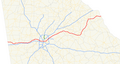
English: State Route 8 (SR 8) is a state highway that runs west-to-east through portions of Haralson, Carroll, Douglas, Cobb, Fulton, DeKalb, Gwinnett, Barrow, Clarke, Oconee, Madison, Franklin, and Hart counties, bisecting the northern part of the state of Georgia. The route runs from its western terminus at US 78 and AL 4 at the Georgia-Alabama state line west of Tallapoosa to its eastern terminus at US 29 at the Georgia-South Carolina state line at the south end of Lake Hartwell. The route is concurrent with either US 29 or US 78 for much of its entire length.
Subcategories
This category has only the following subcategory.
Media in category "Georgia State Route 8"
The following 10 files are in this category, out of 10 total.
-
 Georgia 8 Alternate.svg 600 × 600; 6 KB
-
 Georgia 8 Business.svg 600 × 600; 10 KB
-
 Georgia 8 Connector.svg 600 × 600; 9 KB
-
 Georgia 8 Spur.svg 600 × 600; 11 KB
-
 Atlanta US concurrency (31446559488).jpg 2,986 × 2,240; 1.25 MB
-
 Atlanta US concurrency (31446559688).jpg 3,310 × 2,482; 1.56 MB
-
 Downtown Austell, Georgia.JPG 3,456 × 2,304; 4.44 MB
-
 Downtown Connector sb Exit 249A .75 mile.jpg 5,184 × 3,456; 5.08 MB
-
 Georgia 8.svg 600 × 600; 5 KB
-
 Georgia state route 8 map.png 1,212 × 651; 283 KB


.jpg)
.jpg)

