Category:Girl Scout Little House (Ashland, Kansas)
| Object location | | View all coordinates using: OpenStreetMap |
|---|
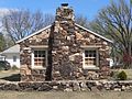
clubhouse in Ashland, Kansas, United States _from_S_1.JPG) | |||||
| Upload media | |||||
| Instance of | |||||
|---|---|---|---|---|---|
| Made from material | |||||
| Location | Ashland, Clark County, Kansas | ||||
| Street address |
| ||||
| Architectural style | |||||
| Main building contractor | |||||
| Occupant | |||||
| Heritage designation |
| ||||
| Inception |
| ||||
 | |||||
|
This is a category about a place or building that is listed on the National Register of Historic Places in the United States of America. Its reference number is 15000142. |
Media in category "Girl Scout Little House (Ashland, Kansas)"
The following 6 files are in this category, out of 6 total.
-
 Girl Scout Little House (Ashland KS) from S 1.JPG 2,184 × 1,319; 727 KB
-
 Girl Scout Little House (Ashland KS) from S 2.JPG 2,301 × 1,285; 742 KB
-
 Girl Scout Little House (Ashland KS) from SE 1.JPG 2,017 × 845; 469 KB
-
 Girl Scout Little House (Ashland KS) from SW 1.JPG 2,522 × 1,592; 1.02 MB
-
 Girl Scout Little House (Ashland KS) from SW 2 long.JPG 2,559 × 1,047; 747 KB
-
 Girl Scout Little House (Ashland KS) from W 1.JPG 1,935 × 1,451; 896 KB
_from_S_2.JPG)
_from_SE_1.JPG)
_from_SW_1.JPG)
_from_W_1.JPG)
_from_SW_2_long.JPG)