Category:Grade II* listed buildings in Powys

Wikimedia list article | |||||
| Upload media | |||||
| Instance of | |||||
|---|---|---|---|---|---|
| |||||
Subcategories
This category has the following 33 subcategories, out of 33 total.
B
- Brecon Castle Hotel (9 F)
C
- Craig Goch Dam (80 F)
- Craig-y-nos Castle (18 F)
D
- Dolforgan Hall (2 F)
F
- Foel Tower (11 F)
G
- Gregynog Hall (17 F)
- Gwernyfed High School (2 F)
J
- Judge's Lodging, Presteigne (10 F)
K
- Knucklas Viaduct (23 F)
L
- Leighton Model Industrial Farm (56 F)
- Lewis Monument, New Radnor (56 F)
M
- Maesmawr Hall (20 F)
- Montgomery Town Hall, Powys (19 F)
N
- National Cycle Collection (4 F)
P
- Penarth, Powys (5 F)
- Penygarreg Dam (80 F)
- Plas Machynlleth (22 F)
- Poultry House, Leighton (7 F)
R
- Rodney's Pillar (35 F)
S
- Stanage Park (31 F)
- Statue of Fame, Powis Castle (10 F)
T
V
- Vaynor Park (7 F)
Y
Media in category "Grade II* listed buildings in Powys"
The following 67 files are in this category, out of 67 total.
-
 19th century limekilns at Talybont-on-Usk (geograph 2953790).jpg 640 × 480; 98 KB
-
 Abbey-Cwm-Hir Hall.jpg 640 × 427; 67 KB
-
 Ashbrook-House, Clyro - 3016665 - geograph.org.uk.jpg 630 × 470; 92 KB
-
 Boughrood Court (3450672780).jpg 750 × 535; 150 KB
-
 Brecon Line of Town Wall at Captains Walk.JPG 1,600 × 1,200; 393 KB
-
 Broad Street, Presteigne (geograph 2470499).jpg 3,373 × 2,201; 3.66 MB
-
 Cabalva House - geograph.org.uk - 848674.jpg 640 × 480; 60 KB
-
 Caban Coch, Elan Valley.jpg 640 × 480; 141 KB
-
 Cantref Selyf, Lion Street, Brecon (geograph 3366566).jpg 480 × 640; 59 KB
-
 Cefnbryntalch - geograph.org.uk - 203602.jpg 640 × 480; 119 KB
-
 Christ College Brecon.JPG 2,592 × 1,468; 2.18 MB
-
 Christ College, Brecon - geograph.org.uk - 340831.jpg 640 × 480; 118 KB
-
 Churchyard cross, St Issui, Patrishow (geograph 4123866).jpg 3,947 × 5,300; 4.5 MB
-
 Courtyard of Powis Castle-geograph.org.uk-2113143.jpg 3,072 × 2,016; 1.32 MB
-
 Doldowlod House (geograph 2015110).jpg 640 × 480; 141 KB
-
 Garreg-ddu reservoir - geograph.org.uk - 2526883.jpg 713 × 950; 302 KB
-
 Glansevern Hall (geograph 2554071).jpg 1,600 × 1,171; 541 KB
-
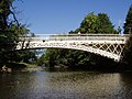
 Glanusk Bridge - geograph.org.uk - 1372768.jpg 426 × 640; 94 KB
-

-
 Grade II* listed Y Plas, Machynlleth (geograph 2873272).jpg 640 × 520; 74 KB
-
 Hamilton House, Brecon - geograph.org.uk - 2629442.jpg 640 × 480; 64 KB
-
 Knucklas viaduct - geograph.org.uk - 233752.jpg 640 × 480; 85 KB
-
 Leighton Poultry House - geograph.org.uk - 924657.jpg 640 × 480; 105 KB
-
 Lime kilns at Llangattock Wharf - geograph.org.uk - 1322184.jpg 640 × 426; 69 KB
-
 Lime kilns Talybont.jpg 1,229 × 823; 403 KB
-
 Llangoed Hall.jpg 2,977 × 1,979; 1.12 MB
-
 Machynlleth Timber house - panoramio.jpg 1,408 × 1,056; 540 KB
-
 Montgomery Canal at Aber-miwl - geograph.org.uk - 52388.jpg 640 × 480; 140 KB
-
 Morgannwg House, Glamorgan Street, Brecon (geograph 4247694).jpg 4,921 × 3,322; 2.22 MB
-
 Natwest Bank in Montgomery (geograph 1934749).jpg 640 × 480; 70 KB
-
 Number 4 Lion Street, Brecon (geograph 3366578).jpg 480 × 640; 77 KB
-
 Old Wegnall End Wall Chimney Set.JPG 1,280 × 960; 339 KB
-
 Old Wegnall Showing Cross Range.JPG 1,280 × 960; 336 KB
-
 Outfall of Upper Neuadd Reservoir - geograph.org.uk - 753939.jpg 480 × 640; 106 KB
-
 Over the Priory Wall ...... (geograph 4252989).jpg 6,016 × 4,000; 4.1 MB
-
 Partrishow church and cross (cropped).jpg 516 × 680; 114 KB
-
 Partrishow church and cross (geograph 3755882).jpg 1,024 × 680; 214 KB
-
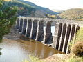
 Pen Y Garreg and Valve Tower.jpg 3,872 × 2,592; 5.38 MB
-
 Penygarreg Dam and Valve Tower, Elan Valley.jpg 916 × 1,632; 563 KB
-
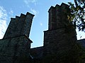
 Perimeter walls of Brecon Cathedral from Priory Hill.jpg 6,000 × 4,000; 17.64 MB
-

-
 Plasau Duon (geograph 1968896).jpg 1,712 × 2,288; 839 KB
-
 Plasnewydd, Carno (geograph 4531559).jpg 2,288 × 1,712; 689 KB
-
 Radnorshire Arms Presteigne (1294841).jpg 1,000 × 714; 87 KB
-
 River Severn, Llandinam bridge - geograph.org.uk - 711424.jpg 640 × 480; 102 KB
-
 Rock House, Montgomery - geograph.org.uk - 1314209.jpg 474 × 640; 121 KB
-
 Royal House, Machynlleth 01.JPG 2,522 × 1,891; 1.26 MB
-
 St Issui's Church and Cross, Partrishow. - geograph.org.uk - 221872.jpg 640 × 480; 149 KB
-
-
 Stone House (geograph 4453583).jpg 800 × 531; 148 KB
-
 Talgarth (geograph 2451854).jpg 2,592 × 1,944; 1.19 MB
-
 Talgarth front.jpg 4,288 × 2,848; 9.04 MB
-
 Talgarth knot garden.jpg 4,288 × 2,848; 8.49 MB
-
 The County House, Brecon - 3376441 - geograph.org.uk.jpg 480 × 630; 58 KB
-
 The Grotto, Maesfron Hall (geograph 3408150).jpg 640 × 480; 113 KB
-
 The Hen Gapel at Pontrobert (geograph 2741040).jpg 640 × 480; 74 KB
-
 The Old Manor House, Presteigne (geograph 2470491).jpg 3,456 × 2,304; 6.19 MB
-
 The Radnorshire Arms, Presteigne (geograph 2469033).jpg 3,456 × 2,304; 5.49 MB
-
 The Slurry Tank^ - geograph.org.uk - 1224851.jpg 640 × 425; 107 KB
-
 Tomb of Robert Owen (1771-1858) - geograph.org.uk - 661997.jpg 640 × 481; 114 KB
-
 Tower House, Talgarth (geograph 3268154).jpg 2,288 × 1,712; 1.01 MB
-
 Tower on Brecon Town Walls.jpg 1,200 × 1,600; 1.29 MB
-
 Trefeca college (3465822292).jpg 750 × 534; 158 KB
-
 Trericket Mill - geograph.org.uk - 158638.jpg 640 × 480; 128 KB
-
 Upper Dolley - geograph.org.uk - 450435.jpg 640 × 480; 74 KB
-
 View to part of Llanerchydol Hall.jpg 640 × 480; 59 KB
-
 The Dderw and Pond - geograph.org.uk - 353175.jpg 640 × 437; 97 KB
.jpg)


.jpg)

.jpg)


.jpg)


.jpg)

.jpg)

.jpg)


.jpg)


.jpg)
.jpg)
.jpg)


.jpg)
.jpg)
.jpg)


.jpg)
.jpg)
.jpg)
.jpg)


.jpg)
.jpg)


.jpg)
.jpg)
.jpg)
.jpg)

_-_geograph.org.uk_-_661997.jpg)
.jpg)

.jpg)


