Category:Grampound with Creed
civil parish in Cornwall, England | |||||
| Upload media | |||||
| Instance of | |||||
|---|---|---|---|---|---|
| Named after | |||||
| Location | Cornwall, South West England, England | ||||
 | |||||
Subcategories
This category has the following 2 subcategories, out of 2 total.
C
G
Media in category "Grampound with Creed"
The following 48 files are in this category, out of 48 total.
-
 A390 at Tregony junction - geograph.org.uk - 4039020.jpg 640 × 313; 48 KB
-
 A390 northbound - geograph.org.uk - 3416631.jpg 640 × 480; 26 KB
-

-
 B3287 approaching A390 junction - geograph.org.uk - 4039230.jpg 640 × 431; 87 KB
-
 Building plot, Hewas Water - geograph.org.uk - 5428811.jpg 3,072 × 2,048; 1.54 MB
-
 Cafe in the lay by on A390 - geograph.org.uk - 4037859.jpg 640 × 331; 43 KB
-
 Cattle near Treswallen - geograph.org.uk - 5220468.jpg 3,060 × 1,832; 1.5 MB
-
 Cornish hillside, Fal valley - geograph.org.uk - 6025699.jpg 1,024 × 681; 126 KB
-
 Cross, Creed Lane - geograph.org.uk - 3935173.jpg 3,216 × 4,288; 6.9 MB
-

-
 Entering Hewas Water - geograph.org.uk - 4037860.jpg 640 × 386; 68 KB
-
 Entrance to Hewas Water - geograph.org.uk - 3416632.jpg 640 × 480; 53 KB
-

-
 Entrance to Tregidgeo Farm - geograph.org.uk - 4039227.jpg 640 × 363; 61 KB
-
 Farmland, Creed - geograph.org.uk - 6151182.jpg 1,024 × 768; 202 KB
-
 Farmland, Creed - geograph.org.uk - 6151187.jpg 1,024 × 768; 264 KB
-
 Farmland, Grampound - geograph.org.uk - 6151249.jpg 1,024 × 768; 246 KB
-
 Farmland, St Ewe - geograph.org.uk - 6133736.jpg 1,024 × 768; 274 KB
-
 Field at Nancor - geograph.org.uk - 1816531.jpg 640 × 480; 60 KB
-
 Field near Treswallen - geograph.org.uk - 5220489.jpg 3,064 × 1,911; 1.73 MB
-
 Fields West of Carwinnick with view of Treswallen Farm - geograph.org.uk - 3937910.jpg 2,931 × 1,831; 1.55 MB
-
 Former Tollhouse by the B3287, Fair Cross, Creed - geograph.org.uk - 6095712.jpg 1,024 × 718; 313 KB
-
 Grampound to Tregony Road - geograph.org.uk - 2773244.jpg 800 × 667; 586 KB
-

-
 Hewas Water from A390 - geograph.org.uk - 4037866.jpg 640 × 365; 64 KB
-
 Lane to Grampound - geograph.org.uk - 5220462.jpg 3,072 × 2,048; 1.42 MB
-
 Lay-by on the A390 at Trevolland - geograph.org.uk - 2352358.jpg 640 × 480; 118 KB
-
 Looking Down - geograph.org.uk - 5480428.jpg 4,603 × 3,451; 2.55 MB
-
 Narrow lane - geograph.org.uk - 4180321.jpg 4,000 × 2,664; 5.83 MB
-
 Old Central Cross on the A390 Fore Street in Grampound (geograph 7055574).jpg 1,536 × 2,048; 566 KB
-

-
 On the A390 - geograph.org.uk - 4180377.jpg 4,000 × 2,664; 5.56 MB
-
 On the B3287 - geograph.org.uk - 4180319.jpg 4,000 × 2,664; 3.75 MB
-
 Ordnance Survey Cut Mark - geograph.org.uk - 5439025.jpg 4,000 × 3,000; 4.38 MB
-
 Ordnance Survey Cut Mark with Bolt - geograph.org.uk - 5439017.jpg 3,791 × 2,843; 3.66 MB
-
 Ordnance Survey Flush Bracket 1779 - geograph.org.uk - 5434744.jpg 4,000 × 3,000; 3.05 MB
-
 Ordnance Survey Flush Bracket G2113 - geograph.org.uk - 5434735.jpg 4,000 × 3,000; 4.8 MB
-

-
 Pepo Lane in Grampound - geograph.org.uk - 5392023.jpg 4,000 × 3,000; 3.75 MB
-
 Road at Hewas Water - geograph.org.uk - 5428640.jpg 3,072 × 2,048; 1.41 MB
-
 Shower clouds as seen from Treswallen near Grampound - geograph.org.uk - 5246284.jpg 5,184 × 2,920; 3.66 MB
-
 The A390 approaching Grampound - geograph.org.uk - 2352372.jpg 640 × 480; 96 KB
-
 Toll house on edge of Grampound - geograph.org.uk - 6005677.jpg 1,442 × 1,600; 1.16 MB
-

-
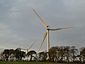 Two turbines north of A390 east of Grampound - geograph.org.uk - 6005679.jpg 1,600 × 1,200; 661 KB
-
 View across the valley near Trencreek Farm - geograph.org.uk - 6139499.jpg 6,000 × 4,000; 6.96 MB
-
 Wind turbine and Penhale Farm - geograph.org.uk - 6139495.jpg 6,000 × 4,000; 6.65 MB
-
 Woodland near River Fal - geograph.org.uk - 3935146.jpg 4,256 × 2,848; 5.07 MB


.jpg)


