Category:Groenestein (Groningen)
| Object location | | View all coordinates using: OpenStreetMap |
|---|
 | |||||
| Upload media | |||||
| Instance of | |||||
|---|---|---|---|---|---|
| Location | Groningen, Netherlands | ||||
| Street address |
| ||||
| Located on street | |||||
| Heritage designation |
| ||||
 | |||||
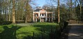
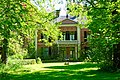
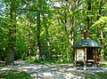
Nederlands: Groenestein is een voormalig landhuis (1685/1871) in Groningen, gelegen in het gelijknamige park (1871, O.J. Quintus) aan de Groenesteinlaan.
Landhuis
|
This is a category about rijksmonument number 484145
|
Park
|
This is a category about rijksmonument number 18463
|
| Address |
|
Media in category "Groenestein (Groningen)"
The following 7 files are in this category, out of 7 total.
-
 "Groenestein", voorgevel - Groningen - 20093890 - RCE.jpg 1,200 × 807; 282 KB
-
 20090321 Groenestein Groningen NL.jpg 3,000 × 1,430; 3.24 MB
-
 20220509 huis Groenestein Groningen.jpg 5,184 × 3,456; 6.4 MB
-
 20220509 ingang park Groenestein Groningen.jpg 3,456 × 5,184; 5.94 MB
-
 20220509 tuin huis Groenestein Groningen door Johan Dijkstra (1896-1978).JPG 3,456 × 5,184; 5.06 MB
-
 Coendersborg Eemspoort Europark.jpeg 4,032 × 3,024; 4.16 MB
-
 Groenestein1.jpg 2,541 × 1,895; 2.75 MB


.JPG)

