Category:Harlingerstraatweg 29, Leeuwarden
| Object location | | View all coordinates using: OpenStreetMap |
|---|
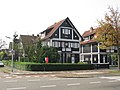
villa in Leeuwarden, Netherlands  | |||||
| Upload media | |||||
| Instance of | |||||
|---|---|---|---|---|---|
| Part of | |||||
| Location | Leeuwarden, Friesland, Netherlands | ||||
| Architectural style | |||||
| Heritage designation |
| ||||
 | |||||
|
This is a category about rijksmonument number 519826
|
| Address |
|
Media in category "Harlingerstraatweg 29, Leeuwarden"
The following 3 files are in this category, out of 3 total.
-

-

-
 RM519826 Leeuwarden - Harlingerstraatweg 29.jpg 2,592 × 1,944; 1.42 MB

