Category:Hatton, Warwickshire
village and civil parish in Warwickshire, UK  | |||||
| Upload media | |||||
| Instance of | |||||
|---|---|---|---|---|---|
| Location | Warwick, Warwickshire, West Midlands, England | ||||
 | |||||
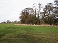
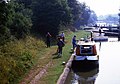
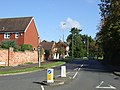
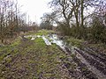
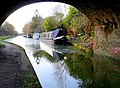
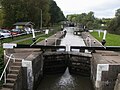
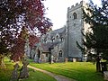
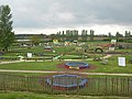
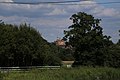
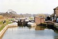
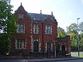
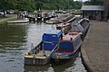
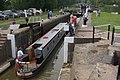
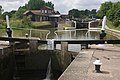
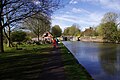
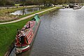
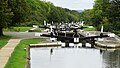
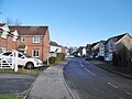
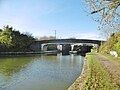
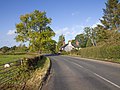
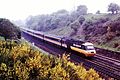
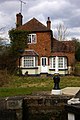
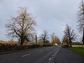
English: Hatton is a village about four miles north of Warwick, England. Notable features include a remarkable series of 21 locks on the Grand Union Canal, a shopping village (Hatton Country World) and a former psychiatric hospital (Central Hospital) that has been turned into a large housing estate while still preserving the original Victorian buildings. The public house, the Waterman, has been noted for its regular large assemblies of motorcycles. Other public houses in the area include the Falcon Inn, although less well known as it is situated further away from the village centre.
Subcategories
This category has the following 6 subcategories, out of 6 total.
H
- Hatton North Junction (18 F)
- Hatton Park (13 F)
- Hatton South Junction (5 F)
Media in category "Hatton, Warwickshire"
The following 200 files are in this category, out of 298 total.
(previous page) (next page)-
 150-017 London Midland Hatton Bank (2) (39814625030).jpg 3,504 × 2,336; 2.68 MB
-
 150-017 London Midland Hatton Bank23-04-10 (40691558494).jpg 3,504 × 2,336; 7.88 MB
-
 37-604 Hatton Bank 11-08-15 (20431229740).jpg 4,274 × 2,787; 2.81 MB
-
 4468 Mallard Hatton south Jcn 1986 (42033001904).jpg 1,831 × 1,221; 1.54 MB
-
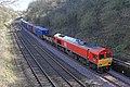 66094 DB Hatton Goods loop 14-03-19 (47454960572).jpg 4,648 × 3,099; 13.33 MB
-
 66094 DB Hatton Goods Loop 14-03-2019 (33639488978).jpg 4,471 × 2,981; 13.87 MB
-
 66177 EWS Hatton 23-02-19 (46644046134).jpg 4,754 × 3,169; 11.8 MB
-
 66702 GBRF Hatton Bank 19-08-15 (20195127183).jpg 4,599 × 3,033; 3.86 MB
-
 68010 Chiltern Railways Hatton Bank 19-08-15 (20628237900).jpg 4,397 × 3,088; 3.92 MB
-
 68013 chiltern railways Hatton Bank 14-03-19 (46600797565).jpg 5,184 × 3,456; 15.67 MB
-
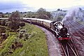 7029 Clun castle Hatton S. Jcn. 1988 (43215989750).jpg 2,461 × 1,640; 2.82 MB
-
 A balding oak near Church Farm - geograph.org.uk - 1403468.jpg 640 × 427; 392 KB
-

-
 A field of wheat near Wedgnock Park Farm - geograph.org.uk - 1401875.jpg 640 × 427; 128 KB
-
 A hidden pond near Budbrooke Farm - geograph.org.uk - 1403456.jpg 640 × 427; 342 KB
-
 A little irrigation near Church Farm - geograph.org.uk - 1403470.jpg 640 × 427; 410 KB
-
 A pond on a low hill - geograph.org.uk - 1401903.jpg 640 × 480; 111 KB
-
 A sharp bend near Budbrooke Farm - geograph.org.uk - 1403461.jpg 640 × 427; 319 KB
-
 A welcome sight - geograph.org.uk - 6060669.jpg 640 × 480; 39 KB
-
 A4177 Birmingham Road near Hatton Park - geograph.org.uk - 1403250.jpg 640 × 427; 377 KB
-
 Alders by Inchford Brook - geograph.org.uk - 1767911.jpg 640 × 480; 424 KB
-
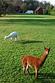 Alpacas in a garden near Hatton locks - geograph.org.uk - 1584901.jpg 426 × 640; 144 KB
-

-
-

-

-

-

-

-

-
 Approach to Hatton Lock no. 42, Grand Union Canal - geograph.org.uk - 3374344.jpg 3,008 × 2,000; 2.25 MB
-
 Approaching Hatton Park - geograph.org.uk - 3147186.jpg 640 × 480; 84 KB
-
 Ascending the Hatton flight - geograph.org.uk - 6266099.jpg 640 × 480; 119 KB
-
 Avenue off Birmingham Road - geograph.org.uk - 3166581.jpg 640 × 480; 78 KB
-
 Barcheston Drive, Hatton Park - geograph.org.uk - 2056689.jpg 2,000 × 1,500; 177 KB
-
 Beausale Lane - geograph.org.uk - 2171242.jpg 640 × 480; 148 KB
-
 Birmingham Road (A4177) - geograph.org.uk - 3166582.jpg 640 × 480; 86 KB
-
 Birmingham Road, Hatton - geograph.org.uk - 3520532.jpg 640 × 480; 527 KB
-
 Birmingham Road-Hockley Road Junction - geograph.org.uk - 3520538.jpg 640 × 480; 494 KB
-
 Blackbrake Plantation - geograph.org.uk - 1401886.jpg 640 × 480; 123 KB
-
 Bridge No 55 near Hatton, Warwickshire - geograph.org.uk - 1709673.jpg 640 × 480; 145 KB
-

-
 Bridge over the M40 - geograph.org.uk - 4469068.jpg 1,500 × 999; 97 KB
-

-
 Bridleway beside a field of wheat - geograph.org.uk - 1401865.jpg 640 × 427; 112 KB
-
 Bridleway near Hatton - geograph.org.uk - 5816210.jpg 1,024 × 683; 322 KB
-
 Bridleway to Rouncil Lane near Turkey Farm - geograph.org.uk - 3370298.jpg 2,000 × 1,500; 511 KB
-
 Bridleway to Wedgnock Park Farm - geograph.org.uk - 3370285.jpg 2,000 × 1,500; 568 KB
-
 Bubble Cars Hatton Bank 1985 (22845087438).jpg 3,226 × 2,151; 1.19 MB
-
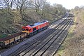
 20-227 Budbrook Junction 23-09-2015 (21663249862).jpg 3,896 × 2,685; 2.08 MB
-
 Budbrooke Farm (2) - geograph.org.uk - 1403450.jpg 640 × 480; 431 KB
-
 Budbrooke Farm - geograph.org.uk - 4641.jpg 640 × 480; 51 KB
-

-
 Class47 Hatton Bank 1985 (30671588093).jpg 4,491 × 2,995; 3.98 MB
-
 Coach Parking, Hatton Country World - geograph.org.uk - 3520575.jpg 640 × 480; 474 KB
-
 Colas Rail 47739 47727 Hatton Locks(3) (29832996320).jpg 3,253 × 2,169; 2.81 MB
-
 Cottage at the Hatton Lock Flight - geograph.org.uk - 5353993.jpg 800 × 515; 115 KB
-
 Cottages on Beausale Lane - geograph.org.uk - 3166588.jpg 640 × 480; 52 KB
-
 Cross country Voyager Hatton 02-07-19 (48188930271).jpg 3,897 × 2,159; 8.08 MB
-
 Curlieu Lane approaches M40 - geograph.org.uk - 1840877.jpg 640 × 480; 461 KB
-
 Curlieu Lane near Nunhold Farm - geograph.org.uk - 1847464.jpg 640 × 480; 614 KB
-
 Dark Lane - geograph.org.uk - 3520546.jpg 640 × 480; 468 KB
-
 Deer Park Farm from the south-east - geograph.org.uk - 1584874.jpg 640 × 426; 319 KB
-
 Depot by Hatton Locks - geograph.org.uk - 4495017.jpg 640 × 426; 52 KB
-
 DMU Hatton 1985 (31108965340).jpg 3,226 × 2,150; 2.04 MB
-
 DMU on Hatton Bank 1985 (30575812615).jpg 4,191 × 2,793; 2.13 MB
-
 Dragonfly sculpture at the Hatton Locks - geograph.org.uk - 4712578.jpg 800 × 548; 186 KB
-
 Driveway to Grove Park - geograph.org.uk - 156279.jpg 640 × 480; 412 KB
-
 DRS Class 68 68008 Hatton 02-07-19 (48188941006).jpg 4,539 × 2,807; 11.13 MB
-
 Entrance to Nunhold Grange - geograph.org.uk - 1841429.jpg 640 × 480; 619 KB
-
 Farmland at Hatton - geograph.org.uk - 5816199.jpg 1,600 × 1,067; 517 KB
-
 Farmland by Hatton locks - geograph.org.uk - 4495016.jpg 640 × 426; 66 KB
-
 Farmland near the Grand Union Canal - geograph.org.uk - 3401586.jpg 1,024 × 782; 142 KB
-
 Farmland towards the Grand Union Canal - geograph.org.uk - 3401591.jpg 1,600 × 1,321; 481 KB
-

-
 Field Margin at Turkey Farm - geograph.org.uk - 2911930.jpg 640 × 479; 112 KB
-
 Fields next to the Grand Union Canal - geograph.org.uk - 4712682.jpg 800 × 538; 110 KB
-
 Footpath across a field of wheat - geograph.org.uk - 1403302.jpg 640 × 480; 491 KB
-
 Footpath by Hatton Wood - geograph.org.uk - 3241750.jpg 2,000 × 1,500; 523 KB
-
 Footpath by Hatton Wood - geograph.org.uk - 3241763.jpg 2,000 × 1,500; 518 KB
-
 Footpath to Grove Park - geograph.org.uk - 3396435.jpg 2,000 × 1,500; 551 KB
-
 Footpath to Hatton Green - geograph.org.uk - 3241900.jpg 2,000 × 1,500; 558 KB
-
 Former Hertford Hill Hospital - geograph.org.uk - 552029.jpg 640 × 480; 59 KB
-
 Former Hospital Driveway - geograph.org.uk - 5852008.jpg 1,600 × 1,043; 698 KB
-
 Former Hospital Gateway - geograph.org.uk - 5852015.jpg 1,600 × 986; 864 KB
-

-
 Former Hospital Lodge, Hatton - geograph.org.uk - 4445899.jpg 640 × 478; 91 KB
-
 Former inmate cemetery, Central Hospital, Hatton - geograph.org.uk - 1785790.jpg 6,048 × 4,032; 1.76 MB
-
 Freightliner 66552 Hatton Locks(2) (29499918734).jpg 3,504 × 2,336; 3.74 MB
-
 Freightliner Freightliner 66594 Hatton Locks(3) (30310930292).jpg 3,253 × 2,169; 3.39 MB
-
 Gate at a junction of footpaths - geograph.org.uk - 1402184.jpg 640 × 480; 114 KB
-
 Grand Union Canal - geograph.org.uk - 2252970.jpg 640 × 472; 102 KB
-
 Grand Union Canal - geograph.org.uk - 2390392.jpg 640 × 476; 101 KB
-
 Grand Union Canal - geograph.org.uk - 5233033.jpg 640 × 480; 78 KB
-

-
 Grand Union Canal Walk - geograph.org.uk - 5233029.jpg 640 × 480; 94 KB
-

-
 Grand Union Canal, Hatton - geograph.org.uk - 2008752.jpg 1,280 × 856; 260 KB
-
 Grand Union Canal, Hatton - geograph.org.uk - 2010510.jpg 1,280 × 856; 300 KB
-
 Grand Union Canal, Hatton Locks - geograph.org.uk - 3188320.jpg 640 × 480; 61 KB
-
 Grand Union Canal, Hatton Locks - geograph.org.uk - 3188352.jpg 640 × 459; 57 KB
-

-

-

-

-
 Hatton Bank - geograph.org.uk - 1403328.jpg 640 × 427; 367 KB
-
 Hatton Bank from Dark Lane - geograph.org.uk - 3396913.jpg 919 × 612; 342 KB
-
 Hatton Bank Lane past Hatton Bank Farm - geograph.org.uk - 1293829.jpg 640 × 480; 101 KB
-
 Hatton Church-Holy Trinity - geograph.org.uk - 4693442.jpg 1,600 × 1,200; 763 KB
-
 Hatton Country World - geograph.org.uk - 3520569.jpg 640 × 480; 470 KB
-
 Hatton Country World - geograph.org.uk - 6228203.jpg 1,600 × 1,200; 727 KB
-

-

-
 Hatton CV35, UK - panoramio (27).jpg 5,472 × 3,648; 6.48 MB
-
 Hatton CV35, UK - panoramio (8).jpg 5,472 × 3,648; 7.03 MB
-
 Hatton dry dock - geograph.org.uk - 3116981.jpg 1,704 × 2,272; 2.69 MB
-
 Hatton Flight - geograph.org.uk - 5199919.jpg 1,024 × 769; 151 KB
-
 Hatton Flight looking down hill from bridge 54 - geograph.org.uk - 2963277.jpg 2,041 × 1,367; 691 KB
-
 Hatton Green, Hockley Road - geograph.org.uk - 3520541.jpg 640 × 480; 478 KB
-
 Hatton Hospital Lodge - geograph.org.uk - 2360086.jpg 640 × 480; 72 KB
-
 Hatton Junction station and M40 (30493183624).jpg 3,793 × 2,191; 1.22 MB
-

-

-

-

-
 Hatton Locks - geograph.org.uk - 2008841.jpg 1,280 × 856; 185 KB
-
 Hatton Locks - geograph.org.uk - 2010056.jpg 1,280 × 856; 233 KB
-
 Hatton Locks - geograph.org.uk - 2010395.jpg 1,280 × 856; 218 KB
-
 Hatton Locks - geograph.org.uk - 2010401.jpg 1,280 × 856; 157 KB
-
 Hatton Locks - geograph.org.uk - 2010408.jpg 855 × 1,280; 165 KB
-
 Hatton Locks - geograph.org.uk - 4072103.jpg 1,280 × 851; 308 KB
-
 Hatton Locks - geograph.org.uk - 4912901.jpg 851 × 1,280; 314 KB
-
 Hatton Locks - geograph.org.uk - 4912909.jpg 1,280 × 851; 358 KB
-
 Hatton Locks - geograph.org.uk - 4912913.jpg 1,280 × 851; 360 KB
-
 Hatton Locks - geograph.org.uk - 4913003.jpg 1,280 × 851; 435 KB
-
 Hatton Locks - geograph.org.uk - 5321643.jpg 1,280 × 851; 438 KB
-
 Hatton Locks - geograph.org.uk - 5321938.jpg 1,280 × 851; 489 KB
-
 Hatton locks - geograph.org.uk - 5964572.jpg 3,264 × 2,448; 3.02 MB
-
 Hatton Locks, Grand Union Canal - view E at Lock 42 - geograph.org.uk - 6337642.jpg 5,184 × 2,920; 6.19 MB
-
 Hatton Locks, Grand Union Canal - view W below Lock 37 - geograph.org.uk - 6337644.jpg 5,184 × 2,920; 6.32 MB
-
 Hatton Long Term Moorings - geograph.org.uk - 4712655.jpg 800 × 663; 198 KB
-

-
 Hatton Park - geograph.org.uk - 5200153.jpg 1,024 × 769; 203 KB
-
 Hatton Park from west of Turkey Farm - geograph.org.uk - 1402442.jpg 640 × 427; 406 KB
-
 Hatton Park Village Hall - geograph.org.uk - 3166586.jpg 640 × 480; 80 KB
-
 Hatton Park, Admington Drive - geograph.org.uk - 5200102.jpg 1,024 × 768; 138 KB
-
 Hatton Park, open space - geograph.org.uk - 5199873.jpg 1,024 × 768; 195 KB
-
 Hatton Rock - geograph.org.uk - 1224345.jpg 640 × 428; 81 KB
-
 Hatton Top Lock - geograph.org.uk - 2009658.jpg 1,280 × 858; 236 KB
-
 Hatton Top Lock - geograph.org.uk - 2010024.jpg 1,280 × 855; 288 KB
-
 Hatton Top Lock - geograph.org.uk - 2433910.jpg 640 × 460; 83 KB
-
 Hatton Top Lock - geograph.org.uk - 2496158.jpg 640 × 482; 80 KB
-
 Hatton Top Lock - geograph.org.uk - 4070311.jpg 1,280 × 851; 329 KB
-
 Hatton Top Lock - geograph.org.uk - 5321601.jpg 1,280 × 851; 478 KB
-
 Hatton Top Lock and Cafe - geograph.org.uk - 2433907.jpg 640 × 480; 77 KB
-
 Hatton Top Lock No 46 - geograph.org.uk - 4712652.jpg 800 × 593; 174 KB
-
 Hatton Top Lock, Grand Union Canal - geograph.org.uk - 2594230.jpg 640 × 480; 87 KB
-
 Hatton Village Hall 19a08.JPG 2,592 × 1,944; 2.55 MB
-

-
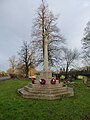 Hatton War Memorial, February 2019 - geograph.org.uk - 6060672.jpg 480 × 640; 76 KB
-
 Hatton Wood in mid-December - geograph.org.uk - 6203535.jpg 1,024 × 614; 209 KB
-
 Hatton Yard Turnover Bridge No 54 - geograph.org.uk - 4712630.jpg 800 × 543; 130 KB
-
 Hatton Yard, Grand Union Canal - geograph.org.uk - 2010391.jpg 1,280 × 856; 155 KB
-
 Hatton, Birmingham Road - geograph.org.uk - 3520530.jpg 640 × 480; 438 KB
-
 Hatton, brassicas - geograph.org.uk - 5200163.jpg 1,024 × 768; 231 KB
-
 Hatton, Bridge No 53 - geograph.org.uk - 5199889.jpg 1,024 × 768; 168 KB
-
 Hatton, Bridge No 54 - geograph.org.uk - 5199928.jpg 1,024 × 768; 152 KB
-
 Hatton, canal bridge - geograph.org.uk - 1099482.jpg 640 × 474; 121 KB
-
 Hatton, canalside house - geograph.org.uk - 1099520.jpg 640 × 477; 127 KB
-
 Hatton, entrance - geograph.org.uk - 5200117.jpg 1,024 × 768; 242 KB
-
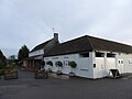
 Hatton, Hatton Arms - geograph.org.uk - 5200159.jpg 1,024 × 768; 172 KB
-
 Hatton, lane - geograph.org.uk - 5200175.jpg 1,024 × 768; 268 KB
-
 Hatton, Lock No 37 - geograph.org.uk - 5199898.jpg 1,024 × 768; 214 KB
-
 Hatton, Lock No 38 - geograph.org.uk - 5199910.jpg 1,024 × 768; 137 KB
-
 Hatton, The Lodge - geograph.org.uk - 5199871.jpg 1,024 × 769; 187 KB
-
 Hatton, Warwick CV35, UK - panoramio (1).jpg 5,472 × 3,648; 5.57 MB
-
 Hatton, Warwick CV35, UK - panoramio (3).jpg 5,472 × 3,648; 6.1 MB
-
 Hatton, Warwick CV35, UK - panoramio.jpg 5,472 × 3,648; 8.88 MB
-
 Hatton-Charingworth Drive - geograph.org.uk - 2374398.jpg 640 × 480; 64 KB
-
 Hatton-Leigh House - geograph.org.uk - 2374781.jpg 640 × 480; 84 KB
-
 Heading north on Beausale Lane - geograph.org.uk - 3166591.jpg 640 × 480; 78 KB
-
 Hill House Farm - geograph.org.uk - 552032.jpg 640 × 480; 68 KB
-
 Hockley Road, Yew Green - geograph.org.uk - 3182265.jpg 2,000 × 1,500; 441 KB
-
 Holes Wood, south of Budbrooke Farm - geograph.org.uk - 1403464.jpg 640 × 427; 398 KB
-
 Horse and House at Hatton - geograph.org.uk - 2252956.jpg 640 × 480; 91 KB
-
 Hospital Conversion, Hatton Park - geograph.org.uk - 5816212.jpg 1,600 × 1,067; 492 KB
-
 House north of Brownley Green - geograph.org.uk - 1767926.jpg 640 × 480; 485 KB
-
 Housing on Barcheston Drive, Hatton - geograph.org.uk - 5816195.jpg 5,472 × 3,162; 1.49 MB
-
 HST 253 053 Hatton Bank 08-05-88 (26931509613).jpg 4,608 × 3,072; 3.14 MB
-
 In a railway cutting - geograph.org.uk - 4495013.jpg 640 × 426; 49 KB
-
 In a railway cutting - geograph.org.uk - 4495014.jpg 640 × 426; 52 KB
-
 In Hatton Wood - geograph.org.uk - 1756998.jpg 640 × 480; 572 KB
-

-
 Junction of Barcheston Drive and Crimscote Square - geograph.org.uk - 3368972.jpg 2,000 × 1,500; 640 KB
-

-

-

-

-
 Lock-keeper's cottage, Hatton Lock - geograph.org.uk - 3374572.jpg 2,000 × 3,008; 1.96 MB
-
 Looking south-east along the A4177 - geograph.org.uk - 6060670.jpg 640 × 480; 63 KB
_(39814625030).jpg)
.jpg)
.jpg)
.jpg)
.jpg)
.jpg)
.jpg)
.jpg)
.jpg)
.jpg)
.jpg)


_-_geograph.org.uk_-_3226462.jpg)
_-_geograph.org.uk_-_3226467.jpg)
_-_geograph.org.uk_-_3226471.jpg)
_-_geograph.org.uk_-_3226475.jpg)
_-_geograph.org.uk_-_3226478.jpg)


_-_geograph.org.uk_-_3166582.jpg)


.jpg)
.jpg)
_-_geograph.org.uk_-_1403450.jpg)


.jpg)

_(29832996320).jpg)


.jpg)


.jpg)
.jpg)


.jpg)


_(29499918734).jpg)
_(30310930292).jpg)


_-_geograph.org.uk_-_6266070.jpg)


.jpg)
.jpg)


.jpg)


.jpg)
.jpg)


.jpg)


