Category:Hauptstraße 30 (Bad Orb)
| Object location | | View all coordinates using: OpenStreetMap |
|---|
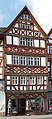
building in Bad Orb, Germany  | |||||
| Upload media | |||||
| Instance of | |||||
|---|---|---|---|---|---|
| Location | Bad Orb, Main-Kinzig-Kreis, Darmstadt Government Region, Hesse, Germany | ||||
| Heritage designation | |||||
 | |||||
This is the category of the Hessian Kulturdenkmal (cultural monument) with the ID Unknown? (Wikidata)
|
Media in category "Hauptstraße 30 (Bad Orb)"
The following 9 files are in this category, out of 9 total.
-
 Bad Orb Fachwerkhaus 01 (fcm).jpg 3,456 × 5,184; 5.32 MB
-
 Bad Orb Fachwerkhaus 02 (fcm).jpg 5,184 × 3,456; 6.36 MB
-
 Bad Orb, Hauptstraße 30-20170126-001.jpg 4,003 × 5,996; 12.9 MB
-
 Bad Orb, Hauptstraße 30-20170126-003.jpg 5,995 × 4,002; 12.72 MB
-
 Bad Orb, Hauptstraße 30-20170126-004.jpg 5,996 × 4,003; 14.81 MB
-
 Bad Orb, Hauptstraße 30-20170126-005.jpg 4,003 × 5,996; 12.79 MB
-
 Bad Orb, Hessen - Alte Häuser in der Hauptstraße (Zeno Ansichtskarten).jpg 1,381 × 2,171; 482 KB
-

-
 Patrizierhaus Nr. 30 (Bad Orb).jpg 6,305 × 14,467; 48.01 MB
.jpg)
.jpg)


.jpg)

.jpg)