Category:Hauptstraße 33a (Roth bei Nürnberg)
| Object location | | View all coordinates using: OpenStreetMap |
|---|
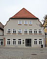
building in Roth, Bavaria, Germany  | |||||
| Upload media | |||||
| Instance of | |||||
|---|---|---|---|---|---|
| Location | Roth, Middle Franconia, Bavaria, Germany | ||||
| Street address |
| ||||
| Heritage designation | |||||
 | |||||
This is the category of the Bavarian Baudenkmal (cultural heritage monument) with the ID D-5-76-143-37 (Wikidata)
|
Deutsch: Roth - Hauptstraße 33a - Bürgerhaus. Zweigeschossig, Halbwalmdach, im Kern wohl 15./16. Jahrhundert, wohl um 1744 überformt.
Media in category "Hauptstraße 33a (Roth bei Nürnberg)"
The following 4 files are in this category, out of 4 total.
-
 Roth bei Nürnberg - Hauptstraße 33a - 01.jpg 3,395 × 4,244; 4.81 MB
-
 Roth bei Nürnberg - Hauptstraße 33a - 02.jpg 2,845 × 3,793; 4.16 MB
-
 Roth bei Nürnberg - Hauptstraße 33a - Detail 01.jpg 3,094 × 3,868; 6.07 MB
-
 Roth, Hauptstraße 33 a, 001.jpg 4,928 × 3,264; 8.8 MB


