Category:Hauptstraße 6 (Herzogenaurach)
| Object location | | View all coordinates using: OpenStreetMap |
|---|
building in Herzogenaurach, Middle Franconia, Germany  | |||||
| Upload media | |||||
| Instance of | |||||
|---|---|---|---|---|---|
| Location | Herzogenaurach, Erlangen-Höchstadt, Middle Franconia, Bavaria, Germany | ||||
| Street address |
| ||||
| Heritage designation | |||||
 | |||||
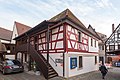
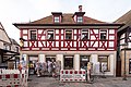
This is the category of the Bavarian Baudenkmal (cultural heritage monument) with the ID D-5-72-132-33 (Wikidata)
|
Deutsch: Herzogenaurach - Hauptstraße 6 - Walmdachhaus mit Fachwerkobergeschoss, frühes 19. Jahrhundert.
Media in category "Hauptstraße 6 (Herzogenaurach)"
The following 7 files are in this category, out of 7 total.
-
 Hauptstraße 6 Herzogenaurach 20180219 001.jpg 6,016 × 4,016; 9.28 MB
-
 Hauptstraße 6 Herzogenaurach 20180219 002.jpg 6,016 × 4,016; 11.02 MB
-
 Hauptstraße 6 Herzogenaurach 20180219 003.jpg 6,016 × 4,016; 10.4 MB
-
 Hauptstraße 6 Herzogenaurach 20180219 004.jpg 6,016 × 4,016; 10.95 MB
-
 Herzogenaurach - Hauptstraße 6 - 01.jpg 3,356 × 4,195; 5.43 MB
-
 Herzogenaurach - Hauptstraße 6 - 02.jpg 3,233 × 4,041; 5.11 MB
-
 Herzogenaurach - Hauptstraße 6 - Detail 01.jpg 3,242 × 4,052; 6.56 MB


