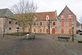
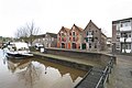
Category:Haven 4, Coevorden
| Object location | | View all coordinates using: OpenStreetMap |
|---|
 | |||||
| Upload media | |||||
| Instance of | |||||
|---|---|---|---|---|---|
| Location | Coevorden, Drenthe, Netherlands | ||||
| Street address |
| ||||
| Located on street |
| ||||
| Occupant | |||||
| Heritage designation |
| ||||
 | |||||
Nederlands: Pakhuis/Arsenaal
|
This is a category about rijksmonument number 11485
|
| Address |
|
Media in category "Haven 4, Coevorden"
The following 16 files are in this category, out of 16 total.
-
 Aanzicht - Coevorden - 20046936 - RCE.jpg 1,200 × 1,195; 322 KB
-
 Aanzicht - Coevorden - 20378749 - RCE.jpg 1,200 × 1,195; 285 KB
-

-

-
 Coevorden Arsenaal.JPG 3,968 × 2,976; 2.32 MB
-

-
-

-

-

-
 Het Arsenaal Coevorden.jpg 417 × 377; 27 KB
-
 Linker zijgevel van pakhuis nummer 6 - Coevorden - 20410146 - RCE.jpg 1,200 × 796; 229 KB
-

-
-
 Vier foto's van arsenaal - Coevorden - 20325824 - RCE.jpg 1,200 × 1,030; 137 KB
-


_behoort_niet_tot_het_voormalige_arsenaal_-_Coevorden_-_20410142_-_RCE.jpg)


_behoort_niet_tot_het_voormalige_arsenaal_-_Coevorden_-_20410144_-_RCE.jpg)

_behoort_niet_tot_het_voormalige_arsenaal_-_Coevorden_-_20410143_-_RCE.jpg)