Category:Heathland of Dorset
Wikimedia category | |||||
| Upload media | |||||
| Instance of | |||||
|---|---|---|---|---|---|
| |||||
Subcategories
This category has the following 6 subcategories, out of 6 total.
A
B
- Boveridge Heath (11 F)
C
H
- Higher Hyde Heath Nature Reserve (132 F)
S
- Studland and Godlingston Heath (153 F)
Media in category "Heathland of Dorset"
The following 200 files are in this category, out of 268 total.
(previous page) (next page)-
 A line of dead tanks - geograph.org.uk - 1521689.jpg 514 × 640; 66 KB
-
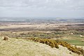
 A view over Povington Heath - geograph.org.uk - 454500.jpg 640 × 426; 79 KB
-
 A well used target - geograph.org.uk - 764549.jpg 640 × 430; 120 KB
-

-

-
 Affpuddle Heath - geograph.org.uk - 406096.jpg 640 × 475; 95 KB
-
 Army Range, Lulworth - geograph.org.uk - 1521082.jpg 640 × 455; 80 KB
-
 Arne Heath - geograph.org.uk - 972469.jpg 427 × 640; 191 KB
-
 Arne Heath - geograph.org.uk - 972475.jpg 640 × 427; 182 KB
-

-
 Artillery range equipment near Worbarrow - geograph.org.uk - 1628645.jpg 640 × 480; 131 KB
-
 Ballard Down , Cyclist, Footpath and Hillside - geograph.org.uk - 1712250.jpg 3,264 × 2,448; 2.34 MB
-
 Ballard Down , Footpath Sign and Hillside - geograph.org.uk - 1712268.jpg 3,264 × 2,448; 3.57 MB
-
 Ballard Down , Grass Path - geograph.org.uk - 1712248.jpg 7,055 × 2,153; 2.38 MB
-
 Ballard Down - geograph.org.uk - 391178.jpg 640 × 480; 74 KB
-
 Battle Plain, Holme Heath - geograph.org.uk - 1156747.jpg 640 × 482; 221 KB
-
 Battle Plain, Holme Heath - geograph.org.uk - 1167938.jpg 640 × 480; 205 KB
-
 Behind Arish Mell - geograph.org.uk - 1521249.jpg 640 × 455; 98 KB
-

-

-
 Bloxworth Heath - geograph.org.uk - 1551239.jpg 640 × 238; 29 KB
-
 Bloxworth Heath - geograph.org.uk - 1551262.jpg 640 × 321; 42 KB
-
 Bloxworth Heath - geograph.org.uk - 1551757.jpg 640 × 320; 47 KB
-
 Bloxworth Heath - geograph.org.uk - 1551763.jpg 640 × 320; 51 KB
-
 Bloxworth Heath - geograph.org.uk - 1551788.jpg 640 × 367; 54 KB
-
 Bloxworth Heath - geograph.org.uk - 1551797.jpg 640 × 320; 51 KB
-
 Bloxworth Heath - geograph.org.uk - 1551807.jpg 640 × 414; 55 KB
-
 Bloxworth Heath - geograph.org.uk - 1551845.jpg 640 × 320; 33 KB
-
 Bloxworth Heath - geograph.org.uk - 1551869.jpg 640 × 320; 32 KB
-
 Bloxworth Heath - geograph.org.uk - 1551914.jpg 640 × 320; 40 KB
-
 Bloxworth Heath - geograph.org.uk - 1551930.jpg 640 × 320; 45 KB
-
 Bloxworth Heath - geograph.org.uk - 1551944.jpg 640 × 320; 31 KB
-

-
 Boggy pool, Town Common - geograph.org.uk - 510708.jpg 640 × 427; 90 KB
-
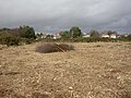
 Bowl barrow on Corfe Common - geograph.org.uk - 695896.jpg 640 × 427; 93 KB
-
 Bridge, Nature Reserve, Upton Heath - geograph.org.uk - 1233842.jpg 640 × 480; 81 KB
-
 Christchurch banner Priory from St Catherine's Hill.JPG 3,500 × 500; 829 KB
-
 Christchurch Priory from St Catherine's Hill.JPG 4,608 × 3,072; 5.07 MB
-
 Cleared forest - geograph.org.uk - 1770384.jpg 640 × 480; 230 KB
-

-
 Coombe Heath - geograph.org.uk - 1721763.jpg 640 × 480; 115 KB
-
 Coombe Heath Reserve - geograph.org.uk - 439052.jpg 640 × 426; 96 KB
-
 Corfe Common - geograph.org.uk - 1337845.jpg 640 × 472; 87 KB
-
 Corfe Common - geograph.org.uk - 1337862.jpg 640 × 480; 120 KB
-
 Corfe Common, donkeys - geograph.org.uk - 1337889.jpg 640 × 480; 85 KB
-
 Corfe Common, mire - geograph.org.uk - 1337878.jpg 640 × 480; 83 KB
-
 Countryside near Warmwell - geograph.org.uk - 1095215.jpg 640 × 428; 108 KB
-
 Dead Tanks - geograph.org.uk - 764541.jpg 640 × 430; 91 KB
-
 Downland, north of Thorncombe Beacon - geograph.org.uk - 1454351.jpg 640 × 480; 62 KB
-
 Duddle Heath - geograph.org.uk - 396031.jpg 640 × 480; 112 KB
-
 Eastern Slopes of St Catherine's Hill and Town Common.JPG 4,608 × 3,072; 6.28 MB
-
 Edge of Holme Heath - geograph.org.uk - 1167943.jpg 640 × 480; 229 KB
-
 Edge of Holme Heath 2 - geograph.org.uk - 1167950.jpg 640 × 480; 232 KB
-
 Ferndown, Ferndown Common - geograph.org.uk - 1352729.jpg 480 × 640; 65 KB
-
 Flowers Barrow Hill Fort - geograph.org.uk - 1521466.jpg 640 × 455; 84 KB
-

-
 Footpath to Knighton Heath - geograph.org.uk - 439174.jpg 640 × 427; 196 KB
-
 Footpath, Affpuddle Heath - geograph.org.uk - 406582.jpg 640 × 480; 96 KB
-
 Gorse on Knighton Heath - geograph.org.uk - 762999.jpg 640 × 430; 115 KB
-
 Grassland below Tyneham Cap - geograph.org.uk - 1192280.jpg 640 × 618; 94 KB
-
 Grip Heath and the Wych Channel, Arne - geograph.org.uk - 852005.jpg 640 × 457; 146 KB
-
 Halcombe Vale - geograph.org.uk - 1521282.jpg 640 × 455; 91 KB
-
 Halcombe Vale - geograph.org.uk - 1521285.jpg 640 × 455; 85 KB
-
 Ham Hill, Poole (1764).jpg 4,288 × 2,848; 4.62 MB
-
 Handcock Coppice - geograph.org.uk - 476020.jpg 480 × 640; 109 KB
-
 Hardown Hill, view west - geograph.org.uk - 519419.jpg 640 × 429; 72 KB
-
 Hardy's Monument - geograph.org.uk - 1022562.jpg 640 × 428; 77 KB
-
 Hardy's Monument - geograph.org.uk - 931885.jpg 640 × 480; 73 KB
-

-
 Hartland Moor National Nature Reserve - geograph.org.uk - 1757696.jpg 3,872 × 2,592; 3.35 MB
-
 Hartland Moor National Nature Reserve - geograph.org.uk - 1757722.jpg 3,872 × 2,592; 2.99 MB
-
 Hartland Moor National Nature Reserve - geograph.org.uk - 1757969.jpg 3,872 × 1,727; 886 KB
-
 Hartland Moor Nature Reserve - geograph.org.uk - 1757939.jpg 640 × 428; 52 KB
-

-
 Heathland, near Bere Regis - geograph.org.uk - 587734.jpg 640 × 480; 281 KB
-
 Holme Lane Plantation - geograph.org.uk - 114525.jpg 640 × 480; 163 KB
-
 Holton Heath - geograph.org.uk - 453175.jpg 640 × 480; 78 KB
-
 Isle of Wight seen from St Catherine's Hill.JPG 4,608 × 3,072; 5.01 MB
-
 Lawson Clump, Dorset - geograph.org.uk - 522419.jpg 640 × 480; 86 KB
-
 Line of littered tanks - geograph.org.uk - 470674.jpg 640 × 429; 88 KB
-
 Long Island across Wych Channel - geograph.org.uk - 449745.jpg 640 × 346; 47 KB
-
 Lower Hyde Heath - geograph.org.uk - 1553847.jpg 640 × 320; 37 KB
-
 Lower Hyde Heath - geograph.org.uk - 1553876.jpg 640 × 320; 36 KB
-
 Lower Hyde Heath - geograph.org.uk - 1553942.jpg 640 × 320; 47 KB
-
 Lower Hyde Heath - geograph.org.uk - 1554020.jpg 640 × 320; 25 KB
-
 Lower Hyde Heath - geograph.org.uk - 1554286.jpg 640 × 320; 42 KB
-
 Lower Hyde Heath - geograph.org.uk - 1554324.jpg 640 × 320; 33 KB
-
 Lower Hyde Heath - geograph.org.uk - 1554354.jpg 640 × 320; 31 KB
-
 Lower Hyde Heath - geograph.org.uk - 1554375.jpg 640 × 320; 99 KB
-
 Lower Hyde Heath - geograph.org.uk - 1555219.jpg 640 × 320; 46 KB
-
 Lulworth area - geograph.org.uk - 1564739.jpg 640 × 480; 77 KB
-
 Lulworth area - geograph.org.uk - 1564749.jpg 640 × 480; 87 KB
-
 Lulworth Range - geograph.org.uk - 1521187.jpg 640 × 455; 72 KB
-
 Lulworth Range - geograph.org.uk - 1521200.jpg 640 × 455; 86 KB
-
 Lulworth Range - geograph.org.uk - 1521242.jpg 640 × 455; 93 KB
-
 Lulworth Range - geograph.org.uk - 1521707.jpg 640 × 455; 90 KB
-
 Lulworth Range - geograph.org.uk - 1521771.jpg 640 × 455; 89 KB
-
 Middlebere Heath, beehives - geograph.org.uk - 1201930.jpg 640 × 480; 81 KB
-
 Middlebere Heath, maintenance work - geograph.org.uk - 1201515.jpg 640 × 480; 59 KB
-
 Middlebere Heath, reedbeds - geograph.org.uk - 1201534.jpg 640 × 480; 67 KB
-
 Middlebere Plateway - geograph.org.uk - 1201946.jpg 640 × 480; 76 KB
-
 Middlebere Plateway - geograph.org.uk - 1201952.jpg 640 × 480; 51 KB
-
 Middlebere, Hart Hide - geograph.org.uk - 1202694.jpg 640 × 480; 59 KB
-
 Military firing range warning sign - geograph.org.uk - 645525.jpg 427 × 640; 117 KB
-
 Nature reserve, Upton Heath - geograph.org.uk - 1233832.jpg 640 × 480; 87 KB
-
 On the ranges - geograph.org.uk - 931996.jpg 640 × 480; 45 KB
-
 Patch of heathland - geograph.org.uk - 222102.jpg 640 × 480; 75 KB
-
 Path junction at Tyneham Cap - geograph.org.uk - 1192386.jpg 640 × 613; 117 KB
-
 Path, Hartland Moor - geograph.org.uk - 718084.jpg 640 × 480; 63 KB
-
 Povington Hill - geograph.org.uk - 1355881.jpg 640 × 455; 73 KB
-
 Povington Hill - geograph.org.uk - 1355885.jpg 640 × 455; 84 KB
-
 Povington Hill - geograph.org.uk - 1355888.jpg 640 × 455; 107 KB
-
 Povington Hill - geograph.org.uk - 1355893.jpg 640 × 455; 98 KB
-
 Povington Hill - geograph.org.uk - 1355899.jpg 640 × 455; 101 KB
-
 Povington Hill - geograph.org.uk - 1521731.jpg 640 × 455; 99 KB
-
 Purbeck heathland - geograph.org.uk - 1156741.jpg 640 × 480; 239 KB
-
 Purbeck Heathland 2 - geograph.org.uk - 1167842.jpg 640 × 480; 226 KB
-
 Range target, Lulworth ranges - geograph.org.uk - 764515.jpg 640 × 430; 67 KB
-
 Ridge of Whiteway Hill - geograph.org.uk - 969071.jpg 640 × 480; 48 KB
-
 Ridge path above South Egliston - geograph.org.uk - 1192367.jpg 640 × 615; 147 KB
-
 Ridgeway towards Tyneham Cap - geograph.org.uk - 1632868.jpg 640 × 480; 73 KB
-
 Road on Affpuddle Heath - geograph.org.uk - 406604.jpg 640 × 480; 97 KB
-
 Round barrows on Nine Barrow Down - geograph.org.uk - 1026393.jpg 640 × 427; 99 KB
-

-
 Sand and gorse, Upton Heath - geograph.org.uk - 1233779.jpg 640 × 480; 88 KB
-
 Sandford near Wareham - geograph.org.uk - 1557098.jpg 640 × 480; 81 KB
-
 Sandford near Wareham - geograph.org.uk - 1557122.jpg 640 × 480; 70 KB
-
 Sandford near Wareham - geograph.org.uk - 1557171.jpg 640 × 480; 51 KB
-
 Sandy beach, Upton Heath - geograph.org.uk - 1233746.jpg 640 × 480; 63 KB
-
 Sheep grazing in the Lulworth Ranges - geograph.org.uk - 764505.jpg 640 × 430; 109 KB
-
 Slepe Heath - geograph.org.uk - 1032086.jpg 640 × 426; 110 KB
-
 Slepe Heath - geograph.org.uk - 851992.jpg 640 × 457; 156 KB
-
 Sopley Common - geograph.org.uk - 515006.jpg 640 × 480; 86 KB
-

-

-
 South West Coast Path, Halcombe Vale - geograph.org.uk - 1521267.jpg 640 × 455; 70 KB
-
 St Catherine's Hill - geograph.org.uk - 534797.jpg 640 × 480; 150 KB
-
 St Catherine's Hill, Dorset, seen from the Avon Valley..JPG 4,608 × 3,072; 6.28 MB
-
 St. Catherine's Hill, Dorset - geograph.org.uk - 211966.jpg 640 × 481; 160 KB
-
 Stoborough Heath - geograph.org.uk - 1473476.jpg 640 × 480; 93 KB
-
 Stoborough Heath NNR - geograph.org.uk - 1473459.jpg 640 × 480; 57 KB
-
 Stoborough Heath, footpath - geograph.org.uk - 1473869.jpg 640 × 480; 64 KB
-
 Stoborough Heath, gates - geograph.org.uk - 1473861.jpg 640 × 480; 106 KB
-
 Stoborough Heath, heathland - geograph.org.uk - 1473907.jpg 640 × 480; 79 KB
-
 Stoborough Heath, mire - geograph.org.uk - 1473485.jpg 640 × 480; 93 KB
-
 Stoborough Heath, mire - geograph.org.uk - 1473892.jpg 640 × 480; 104 KB
-
 Stoborough Heath, mire - geograph.org.uk - 1473911.jpg 640 × 480; 76 KB
-
 Stoborough Heath, track - geograph.org.uk - 1473900.jpg 640 × 480; 62 KB
-
 Stoborough Heath, tramway - geograph.org.uk - 1473884.jpg 640 × 480; 61 KB
-
 Summer on Egdon Heath - geograph.org.uk - 460579.jpg 480 × 640; 142 KB
-
 Swyre Head - geograph.org.uk - 535404.jpg 640 × 480; 91 KB
-
 Tank Ranges, East Holme - geograph.org.uk - 764588.jpg 640 × 430; 68 KB
-
 The Hardy Monument on Black Down - geograph.org.uk - 1087468.jpg 640 × 480; 81 KB
-
 The Moors, Purbeck - geograph.org.uk - 851991.jpg 640 × 457; 115 KB
-
 The slopes of Povington Hill - geograph.org.uk - 726132.jpg 640 × 426; 55 KB
-
 Track across Knighton Heath - geograph.org.uk - 763002.jpg 640 × 430; 114 KB
-
 Track leading on to Whiteways Hill - geograph.org.uk - 764553.jpg 640 × 430; 114 KB
-
 Track through Moreton Plantation - geograph.org.uk - 406477.jpg 640 × 480; 90 KB
-
 Track to Tyneham - geograph.org.uk - 1521762.jpg 640 × 455; 102 KB
-
 Trigon Heath - geograph.org.uk - 1553833.jpg 640 × 321; 28 KB
-
 Tyneham Cap - geograph.org.uk - 1215628.jpg 640 × 480; 73 KB
-
 Tyneham Farm - geograph.org.uk - 1521784.jpg 640 × 455; 96 KB
-
 Tyneham Farm - geograph.org.uk - 1521800.jpg 640 × 455; 108 KB
-
 Tyneham Farm - geograph.org.uk - 1521805.jpg 640 × 455; 100 KB
-
 Tyneham Farm - geograph.org.uk - 1521815.jpg 640 × 455; 93 KB
-
 Tyneham Farm and Povington Hill - geograph.org.uk - 1521792.jpg 640 × 455; 115 KB
-
 Upton Heath - geograph.org.uk - 1516125.jpg 640 × 480; 98 KB
-
 Upton Heath - geograph.org.uk - 453039.jpg 640 × 480; 155 KB
-
 Upton Heath looking towards Poole Harbour.JPG 4,000 × 3,000; 2.06 MB
-
 Upton Heath Nature Reserve - geograph.org.uk - 1233811.jpg 480 × 640; 98 KB
-
 Upton Heath Nature Reserve - geograph.org.uk - 453098.jpg 640 × 480; 112 KB
-
 Upton Heath, bog scene - geograph.org.uk - 1516241.jpg 640 × 480; 94 KB
-
 Upton Heath, heathland - geograph.org.uk - 1516199.jpg 640 × 480; 69 KB
-
 Upton, conservation work - geograph.org.uk - 1728054.jpg 640 × 480; 98 KB
-
 Valley on the slopes of Povington Hill - geograph.org.uk - 764560.jpg 640 × 430; 102 KB
-

-

-

-
 View from Rainbarrows - geograph.org.uk - 786472.jpg 640 × 360; 60 KB
-
 View over East Holme Ranges - geograph.org.uk - 764573.jpg 640 × 430; 67 KB
-
 View southwest from Duddle Heath - geograph.org.uk - 396422.jpg 640 × 427; 68 KB
-
 Wareham - Bloxworth Heath - geograph.org.uk - 1551205.jpg 640 × 320; 35 KB
-
 Wareham - geograph.org.uk - 1574461.jpg 640 × 320; 29 KB
-
 Wareham - Gore Heath - geograph.org.uk - 1542161.jpg 640 × 475; 71 KB
-
 Wareham - Lower Hyde Heath - geograph.org.uk - 1567466.jpg 640 × 393; 49 KB
-
 Wareham - Lower Hyde Heath - geograph.org.uk - 1567477.jpg 640 × 480; 88 KB
-
 Wareham - Worgret Heath - geograph.org.uk - 1574224.jpg 640 × 320; 24 KB
-
 Wareham - Worgret Heath - geograph.org.uk - 1574607.jpg 640 × 480; 21 KB
-
 Wareham Bloxworth Heath - geograph.org.uk - 1551213.jpg 640 × 320; 35 KB
-
 Wareham Forest - geograph.org.uk - 1559856.jpg 640 × 333; 51 KB
-
 Wareham Forest Walk - Decoy Heath - geograph.org.uk - 1534521.jpg 640 × 480; 80 KB
-
 Wareham Forest Walk - Decoy Heath - geograph.org.uk - 1534525.jpg 640 × 352; 76 KB
-
 Wareham Forest Walk - Decoy Heath - geograph.org.uk - 1534532.jpg 640 × 480; 95 KB
-
 Wareham Forest Walk - Decoy Heath - geograph.org.uk - 1540016.jpg 640 × 480; 87 KB
-
 Wareham Forest Walk - Decoy Heath - geograph.org.uk - 1540042.jpg 640 × 480; 87 KB
-
 Wareham Forest Walk - Decoy Heath - geograph.org.uk - 1550394.jpg 640 × 320; 54 KB
-
 Wareham Forest Walk - Decoy Heath - geograph.org.uk - 1550397.jpg 640 × 333; 33 KB
-
 Wareham Forest Walk - Decoy Heath - geograph.org.uk - 1550402.jpg 640 × 376; 35 KB
-
 Wareham Forest Walk - Decoy Heath - geograph.org.uk - 1550406.jpg 640 × 391; 33 KB
-
 Wareham Forest Walk - Decoy Heath - geograph.org.uk - 1550410.jpg 640 × 320; 35 KB


.jpg)


_-_geograph.org.uk_-_1490834.jpg)


