Category:Heidense Kapel, Stroe (Noord-Holland)
| Object location | | View all coordinates using: OpenStreetMap |
|---|
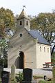
Nederlands: Herbouwde kapel op de begraafplaats van Stroe in Noord-Holland - anno 2016
church in Stroe (Hollands Kroon), Netherlands  | |||||
| Upload media | |||||
| Instance of | |||||
|---|---|---|---|---|---|
| Location | Stroe, North Holland, Hollands Kroon, North Holland, Netherlands | ||||
| official website | |||||
 | |||||
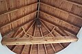
Media in category "Heidense Kapel, Stroe (Noord-Holland)"
The following 10 files are in this category, out of 10 total.
-
 Heidenske kapel, Stroe.jpg 3,468 × 2,315; 1.84 MB
-
 Stroe Heidense Kapel.jpg 683 × 1,024; 200 KB
-
 Stroe, Heidenske kapel, gevelstien fan Willibrord.jpg 2,190 × 2,308; 1.21 MB
-
 Stroe-Heidense kapel-2021-009.jpg 4,752 × 3,168; 5.16 MB
-
 Stroe-Heidense kapel-2021-010.jpg 4,752 × 3,168; 6.5 MB
-
 Stroe-Heidense kapel-2021-015.jpg 4,752 × 3,168; 6.6 MB
-
 Stroe-Heidense kapel-2021-016.jpg 4,752 × 3,168; 7.79 MB
-
 Stroe-Heidense kapel-2021-019.jpg 3,168 × 4,752; 5.26 MB
-
 Stroe-Heidense kapel-2021-022.jpg 3,168 × 4,752; 5.51 MB
-
 Stroe-Heidense kapel-2021-028.jpg 3,168 × 4,752; 4.6 MB


