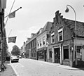
Category:Herenstraat 51, Voorburg
| Object location | | View all coordinates using: OpenStreetMap |
|---|
 | |||||
| Upload media | |||||
| Instance of |
| ||||
|---|---|---|---|---|---|
| Location | Voorburg, Leidschendam-Voorburg, South Holland, Netherlands | ||||
| Street address |
| ||||
| Located on street |
| ||||
| Heritage designation |
| ||||
 | |||||
|
This is a category about rijksmonument number 37942
|
| Address |
|
Media in category "Herenstraat 51, Voorburg"
The following 7 files are in this category, out of 7 total.
-
 Overzicht - Voorburg - 20245459 - RCE.jpg 1,200 × 952; 224 KB
-
 Voor- en zijgevel - Voorburg - 20245475 - RCE.jpg 1,200 × 1,078; 252 KB
-
 Voor- en zijgevel - Voorburg - 20245476 - RCE.jpg 960 × 1,200; 228 KB
-
 Voor- en zijgevel - Voorburg - 20245477 - RCE.jpg 960 × 1,200; 243 KB
-
 Voorburg - Herenstraat 51 (2).jpg 2,592 × 1,944; 1.53 MB
-
 Voorburg - Herenstraat 51.jpg 1,944 × 2,592; 1.48 MB
-
 Voorgevel - Voorburg - 20245474 - RCE.jpg 803 × 1,200; 172 KB


.jpg)
