Category:Hervormde Kerk (Den Bommel)
| Object location | | View all coordinates using: OpenStreetMap |
|---|
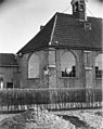
church building in Goeree-Overflakkee, Netherlands  | |||||
| Upload media | |||||
| Instance of | |||||
|---|---|---|---|---|---|
| Location | Den Bommel, South Holland, Netherlands | ||||
| Street address |
| ||||
| Located on street |
| ||||
| Heritage designation |
| ||||
 | |||||
Nederlands: Hervormde Kerk Den Bommel - anno 1646
|
This is a category about rijksmonument number 31706
|
| Address |
|
Subcategories
This category has only the following subcategory.
Media in category "Hervormde Kerk (Den Bommel)"
The following 13 files are in this category, out of 13 total.
-
 Commonwealth war graves - The Netherlands - Den Bommel general cemetery.jpg 3,264 × 2,448; 3.12 MB
-
 Den Bommel, de NH kerk RM31706 foto2 2015-05-24 16.28.jpg 4,352 × 3,264; 11.44 MB
-
 Exterieur - Den Bommel - 20038011 - RCE.jpg 798 × 1,200; 217 KB
-
-

-

-
 In restauratie - Den Bommel - 20038017 - RCE.jpg 1,190 × 1,200; 280 KB
-
 In restauratie - Den Bommel - 20038018 - RCE.jpg 1,190 × 1,200; 274 KB
-

-
 Overzicht oostgevel - Den Bommel - 20377208 - RCE.jpg 1,200 × 1,197; 345 KB
-
 Standbeeld Ollie B Bommel.jpg 3,456 × 4,608; 8.81 MB
-
 Voorzijde, zuid-west zijde - Den Bommel - 20038016 - RCE.jpg 951 × 1,200; 233 KB
-
 Zuid-gevel - Den Bommel - 20038015 - RCE.jpg 1,200 × 953; 283 KB


