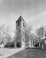
Category:Hervormde kerk, Nieuwenhoorn
| Object location | | View all coordinates using: OpenStreetMap |
|---|
church building in Nieuwenhoorn, Netherlands  | |||||
| Upload media | |||||
| Instance of | |||||
|---|---|---|---|---|---|
| Location | Nieuwenhoorn, South Holland, Netherlands | ||||
| Street address |
| ||||
| Heritage designation |
| ||||
 | |||||
Nederlands: Hervormde Kerk Nieuwenhoorn - anno 15e eeuw
|
This is a category about rijksmonument number 21437
|
| Address |
|
Subcategories
This category has only the following subcategory.
I
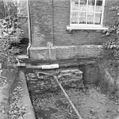
Media in category "Hervormde kerk, Nieuwenhoorn"
The following 19 files are in this category, out of 19 total.
-
 Detail torenkruis - Nieuwenhoorn - 20164334 - RCE.jpg 1,190 × 1,200; 265 KB
-
 Detail torenkruis - Nieuwenhoorn - 20164335 - RCE.jpg 1,200 × 1,200; 386 KB
-
 Detail torenkruis - Nieuwenhoorn - 20164336 - RCE.jpg 1,195 × 1,200; 282 KB
-

-
 Exterieur NOORDGEVEL - Nieuwenhoorn - 20307321 - RCE.jpg 1,200 × 965; 387 KB
-
 Exterieur OVERZICHT - Nieuwenhoorn - 20307320 - RCE.jpg 954 × 1,200; 249 KB
-
 Exterieur OVERZICHT VANUIT HET NOORDOOSTEN - Nieuwenhoorn - 20309652 - RCE.jpg 1,200 × 954; 389 KB
-
-

-
 Exterieur STEEN MET INSCRIPTIE (1512) IN ZUIDGEVEL - Nieuwenhoorn - 20307323 - RCE.jpg 1,200 × 1,200; 316 KB
-
 Exterieur ZUIDGEVEL - Nieuwenhoorn - 20307322 - RCE.jpg 950 × 1,200; 295 KB
-
 Kerk en toren naar het noord-oosten - Nieuwenhoorn - 20164325 - RCE.jpg 966 × 1,200; 235 KB
-
 Kerk en toren naar het oosten - Nieuwenhoorn - 20164326 - RCE.jpg 962 × 1,200; 231 KB
-
 Nieuwenhoorn NH kerk 20-07-2010.jpg 1,639 × 2,000; 567 KB
-
 Ontwerptekening van de consistorie, door G. Spoon - Nieuwenhoorn - 20385302 - RCE.jpg 1,200 × 1,197; 293 KB
-
 Ontwerptekening, door G. Spoon - Nieuwenhoorn - 20385303 - RCE.jpg 1,200 × 1,155; 284 KB
-

-
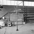 Torenkruis - Nieuwenhoorn - 20164332 - RCE.jpg 1,190 × 1,200; 238 KB
-
 Torenkruis - Nieuwenhoorn - 20164333 - RCE.jpg 1,183 × 1,200; 331 KB


_IN_ZUIDGEVEL_-_Nieuwenhoorn_-_20307323_-_RCE.jpg)


