Category:Hervormde kerk (Babyloniënbroek)
| Object location | | View all coordinates using: OpenStreetMap |
|---|
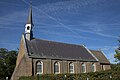
church building in Aalburg, Netherlands  | |||||
| Upload media | |||||
| Instance of | |||||
|---|---|---|---|---|---|
| Location | Babyloniënbroek, Altena, North Brabant, Netherlands | ||||
| Street address |
| ||||
| Located on street |
| ||||
| Heritage designation |
| ||||
| Inception |
| ||||
| Significant event |
| ||||
 | |||||
Nederlands: PKN Hervormd, Babylonienbroek - anno 15e eeuw
|
This is a category about rijksmonument number 6808
|
| Address |
|
Media in category "Hervormde kerk (Babyloniënbroek)"
The following 15 files are in this category, out of 15 total.
-
 20070705Korenschoof.jpg 1,600 × 1,250; 347 KB
-
 De Hervormde kerk De Korenschoof in Babylonienbroek.jpg 4,770 × 3,177; 4.52 MB
-
 Exterieur naar het noord-westen - Babyloniënbroek - 20027329 - RCE.jpg 1,200 × 946; 294 KB
-
 Exterieur van het oude koor - Babyloniënbroek - 20027330 - RCE.jpg 1,200 × 957; 317 KB
-
 Hervormde kerk Babylonienbroek.jpg 6,016 × 4,012; 26.05 MB
-
 Hervormde kerk te Babylonienbroek2.jpg 6,333 × 5,299; 27.32 MB
-

-
 Ned. Herv. kerk.jpg 532 × 800; 233 KB
-
 Schilderingen op oostwand boven trekbalk - Babyloniënbroek - 20027334 - RCE.jpg 1,200 × 1,183; 458 KB
-
 Schilderingen op oostwand boven trekbalk - Babyloniënbroek - 20027335 - RCE.jpg 1,200 × 1,193; 458 KB
-
 Schilderingen op oostwand boven trekbalk - Babyloniënbroek - 20356462 - RCE.jpg 1,182 × 1,200; 349 KB
-
 Schilderingen op oostwand boven trekbalk - Babyloniënbroek - 20356464 - RCE.jpg 1,198 × 1,200; 349 KB
-
 Schilderingen op oostwand boven trekbalk - Babyloniënbroek - 20356466 - RCE.jpg 1,186 × 1,200; 324 KB
-
 Voorzijde - Babyloniënbroek - 20027331 - RCE.jpg 1,200 × 805; 180 KB
-
 Zijgevel - Babyloniënbroek - 20027332 - RCE.jpg 793 × 1,200; 193 KB


