Category:Hervormde kerk (Vlagtwedde)
| Object location | | View all coordinates using: OpenStreetMap |
|---|
church building in Vlagtwedde, Netherlands  | |||||
| Upload media | |||||
| Instance of | |||||
|---|---|---|---|---|---|
| Location | Vlagtwedde, Vlagtwedde | ||||
| Street address |
| ||||
| Located on street |
| ||||
| Heritage designation |
| ||||
 | |||||
|
This is a category about rijksmonument number 37466
|
| Address |
|
Media in category "Hervormde kerk (Vlagtwedde)"
The following 8 files are in this category, out of 8 total.
-
 Interieur naar het oosten - Vlagtwedde - 20242896 - RCE.jpg 887 × 1,200; 126 KB
-
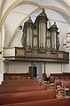 Interieur, aanzicht orgel - Vlagtwedde - 20417575 - RCE.jpg 792 × 1,200; 137 KB
-
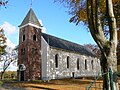
 Kerk van Vlagtwedde.jpg 1,296 × 972; 159 KB
-
 Kerk vanuit het noord-oosten - Vlagtwedde - 20242894 - RCE.jpg 3,348 × 2,395; 2.5 MB
-
 Kerk vanuit het zuid-oosten - Vlagtwedde - 20242895 - RCE.jpg 1,200 × 876; 251 KB
-
 Vlagtwedde 01.JPG 2,816 × 2,112; 2.95 MB
-
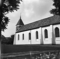 Zuid-gevel - Vlagtwedde - 20242898 - RCE.jpg 1,200 × 1,193; 275 KB
-
 Zuid-gevel met toren - Vlagtwedde - 20242897 - RCE.jpg 1,200 × 1,200; 263 KB


