Category:Higashi-ku, Sakai
Municipalities of Osaka prefecture | ||||||||
|---|---|---|---|---|---|---|---|---|
| Cities |
|  | ||||||
| Towns | ||||||||
| Village | ||||||||

日本語: 日本国・大阪府堺市東区に関するカテゴリ。
| Object location | | View all coordinates using: OpenStreetMap |
|---|
one of seven wards of the City of Sakai, Japan  | |||||
| Upload media | |||||
| Instance of | |||||
|---|---|---|---|---|---|
| Location | Sakai, Osaka Prefecture, Japan | ||||
| Population |
| ||||
| Area |
| ||||
| official website | |||||
 | |||||
Subcategories
This category has the following 4 subcategories, out of 4 total.
- History of Higashi-ku, Sakai (1 F)
Media in category "Higashi-ku, Sakai"
The following 6 files are in this category, out of 6 total.
-
 Kitanoda001.JPG 2,048 × 1,536; 1.19 MB
-
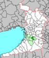
 Location of Higashi ward Sakai city Osaka prefecture Japan.svg 344 × 389; 17 KB
-
 Osaka Sakai-city higashi.png 250 × 294; 6 KB
-
 Route 34&38 (Osaka) in Sakai01.jpg 1,632 × 1,224; 384 KB
-
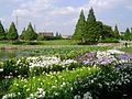 Shirasagi garden001.jpg 800 × 600; 151 KB
-
 野田城石碑.jpg 3,264 × 2,448; 1.16 MB


_in_Sakai01.jpg)

