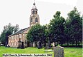
Category:High Church, Kilmarnock
| Object location | | View all coordinates using: OpenStreetMap |
|---|
church in East Ayrshire, Scotland, UK .jpg) | |||||
| Upload media | |||||
| Instance of | |||||
|---|---|---|---|---|---|
| Location |
| ||||
| Architectural style | |||||
| Heritage designation |
| ||||
 | |||||
Media in category "High Church, Kilmarnock"
The following 39 files are in this category, out of 39 total.
-
 05254 Ex Old High Kirk, Kilmarnock 001.jpg 768 × 1,024; 384 KB
-
 05254 Ex Old High Kirk, Kilmarnock 002.jpg 1,024 × 768; 408 KB
-
 05254 Ex Old High Kirk, Kilmarnock 003.jpg 1,024 × 768; 349 KB
-
 05254 Ex Old High Kirk, Kilmarnock 004.jpg 768 × 1,024; 341 KB
-
 05254 Ex Old High Kirk, Kilmarnock 005.jpg 768 × 1,024; 377 KB
-
 05254 Ex Old High Kirk, Kilmarnock 006.jpg 768 × 1,024; 396 KB
-
 05254 Ex Old High Kirk, Kilmarnock 007.jpg 1,024 × 768; 357 KB
-
 05254 Ex Old High Kirk, Kilmarnock 008.jpg 1,024 × 768; 363 KB
-
 05254 Ex Old High Kirk, Kilmarnock 009.jpg 1,024 × 768; 177 KB
-
 05254 Ex Old High Kirk, Kilmarnock 010.jpg 768 × 1,024; 366 KB
-
 05254 Ex Old High Kirk, Kilmarnock 011.jpg 768 × 1,024; 350 KB
-
 05254 Ex Old High Kirk, Kilmarnock 012.jpg 1,024 × 768; 366 KB
-
 05254 Ex Old High Kirk, Kilmarnock 013.jpg 768 × 1,024; 397 KB
-
 05254 Ex Old High Kirk, Kilmarnock 014.jpg 768 × 1,024; 383 KB
-
 05254 Ex Old High Kirk, Kilmarnock 015.jpg 768 × 1,024; 326 KB
-
 05254 Ex Old High Kirk, Kilmarnock 016.jpg 1,024 × 768; 339 KB
-
 05254 Ex Old High Kirk, Kilmarnock 017.jpg 768 × 1,024; 384 KB
-
 05254 Ex Old High Kirk, Kilmarnock 018.jpg 768 × 1,024; 300 KB
-
 05254 Ex Old High Kirk, Kilmarnock 019.jpg 768 × 1,024; 384 KB
-
 05254 Ex Old High Kirk, Kilmarnock 020.jpg 1,024 × 768; 346 KB
-
 05254 Ex Old High Kirk, Kilmarnock 021.jpg 1,024 × 768; 397 KB
-
 05254 Ex Old High Kirk, Kilmarnock 022.jpg 768 × 1,024; 352 KB
-
 05254 Ex Old High Kirk, Kilmarnock 023.jpg 1,024 × 768; 382 KB
-
 05254 Ex Old High Kirk, Kilmarnock 024.jpg 1,024 × 768; 372 KB
-
 05254 Ex Old High Kirk, Kilmarnock 025.jpg 768 × 1,024; 397 KB
-
 05254 Ex Old High Kirk, Kilmarnock 026.jpg 1,024 × 740; 24 KB
-
 05254 Ex Old High Kirk, Kilmarnock 027.jpg 1,024 × 699; 30 KB
-
 05254 Ex Old High Kirk, Kilmarnock 028.jpg 723 × 1,024; 30 KB
-
 05254 Ex Old High Kirk, Kilmarnock 029.jpg 738 × 1,024; 42 KB
-
 05254 Ex Old High Kirk, Kilmarnock 030.jpg 1,024 × 738; 26 KB
-
 05254 Ex Old High Kirk, Kilmarnock 031.jpg 2,304 × 3,072; 2.24 MB
-
 05254 Ex Old High Kirk, Kilmarnock 032.jpg 2,304 × 3,072; 2.09 MB
-
 05254 Ex Old High Kirk, Kilmarnock 033.jpg 2,304 × 3,072; 2.21 MB
-
 05254 Ex Old High Kirk, Kilmarnock 034.jpg 2,304 × 3,072; 2.16 MB
-
 05254 Ex Old High Kirk, Kilmarnock 035.jpg 2,304 × 3,072; 2.2 MB
-
 05254 Ex Old High Kirk, Kilmarnock 036.jpg 2,304 × 3,072; 2.12 MB
-
 05254 Ex Old High Kirk, Kilmarnock 037.jpg 2,304 × 3,072; 2.27 MB
-
 05254 Ex Old High Kirk, Kilmarnock 038.jpg 2,304 × 3,072; 2.22 MB
-
 Old High Kirk, Kilmarnock (geograph 2684968).jpg 1,600 × 1,094; 467 KB


