Category:High Littleton
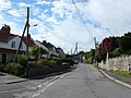
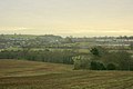
English: The village of High Littleton and its hamlets of Hallatrow and Amesbury form a civil parish and are located in the county of Somerset and straddle both the A39 and A37, 8 miles from Bath, 12 miles from Wells and 10 miles from Bristol. The parish has a population of 2,086. Nearby are the villages of Clutton, Temple Cloud and Timsbury.
village in Somerset, England _Holy_Trinity_Church_-_geograph.org.uk_-_67726.jpg) | |||||
| Upload media | |||||
| Instance of | |||||
|---|---|---|---|---|---|
| Location | Bath and North East Somerset, Somerset, South West England, England | ||||
 | |||||
Media in category "High Littleton"
The following 91 files are in this category, out of 91 total.
-
 2010 , A39 at Hallatrow heading east - geograph.org.uk - 1930752.jpg 800 × 670; 241 KB
-
 2010 , A39 heading west out of Hallatrow - geograph.org.uk - 1930760.jpg 800 × 616; 123 KB
-
 2010 , A39 squeezing through Hallatrow - geograph.org.uk - 1998158.jpg 800 × 623; 150 KB
-
 A Harlequin exercises - geograph.org.uk - 5144864.jpg 2,304 × 1,704; 1.52 MB
-
 A little entrance in High Littleton - geograph.org.uk - 5146001.jpg 2,304 × 1,704; 1.3 MB
-
 A37 Bristol Road nears A39 junction - geograph.org.uk - 5817415.jpg 1,024 × 768; 87 KB
-
 A37 northbound - geograph.org.uk - 3052098.jpg 640 × 450; 50 KB
-
 A39 downhill to Hallatrow - geograph.org.uk - 4121005.jpg 1,024 × 698; 177 KB
-
 A39 junction with A37 - geograph.org.uk - 4137813.jpg 1,600 × 1,074; 377 KB
-
 A39 junction with B3355 at Hallatrow - geograph.org.uk - 4137437.jpg 1,600 × 1,073; 483 KB
-
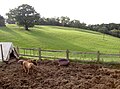
 Barn and pasture near High Littleton - geograph.org.uk - 1087677.jpg 640 × 476; 161 KB
-
 Benchmark on Dando's - geograph.org.uk - 5144954.jpg 2,304 × 1,704; 1.64 MB
-
 Beware of footballs^ - geograph.org.uk - 5144826.jpg 2,304 × 1,704; 1.68 MB
-
 Bungalows on the east of Hallatrow - geograph.org.uk - 5055797.jpg 1,600 × 1,200; 692 KB
-
 Bus stop and shelter, High Littleton - geograph.org.uk - 5473425.jpg 1,600 × 1,200; 803 KB
-
 Bus stop on A39, Rosewell, south of High Littleton - geograph.org.uk - 5473428.jpg 1,600 × 1,201; 720 KB
-
 Car Wash, White Cross - geograph.org.uk - 5055804.jpg 1,600 × 1,067; 525 KB
-
 Chapel converted at White Cross - geograph.org.uk - 1084369.jpg 640 × 503; 141 KB
-
 Church centre - geograph.org.uk - 5146017.jpg 2,304 × 1,704; 1.76 MB
-
 Church Hall - geograph.org.uk - 5146054.jpg 2,304 × 1,704; 1.41 MB
-
 Closed ranks - geograph.org.uk - 5144935.jpg 2,304 × 1,704; 1.8 MB
-
 Cottages, High Littleton - geograph.org.uk - 364797.jpg 640 × 455; 66 KB
-
 Countryside near Paulton - geograph.org.uk - 2861030.jpg 640 × 480; 88 KB
-
 Crimson gown - geograph.org.uk - 5146021.jpg 1,704 × 2,304; 1.82 MB
-
 Dando's Store - geograph.org.uk - 5144949.jpg 1,704 × 2,304; 1.59 MB
-
 East from Langford's Lane - geograph.org.uk - 1084355.jpg 640 × 482; 173 KB
-
 Eighteenth century house - geograph.org.uk - 5145990.jpg 1,704 × 2,304; 2.14 MB
-
 Entering High Littleton on A39 - geograph.org.uk - 4137413.jpg 1,600 × 1,048; 532 KB
-
 Entrance to Hallatrow Business Park - geograph.org.uk - 5473459.jpg 1,600 × 1,200; 801 KB
-

-
 Entrance to Withy Mills Farm - geograph.org.uk - 991067.jpg 640 × 448; 65 KB
-
 Father of English Geology, Cool^ - geograph.org.uk - 293093.jpg 640 × 427; 187 KB
-
 Fields at High Littleton - geograph.org.uk - 2861049.jpg 640 × 480; 80 KB
-
 Fitness trail in wood - geograph.org.uk - 5144880.jpg 2,304 × 1,704; 1.8 MB
-
 From Langford's Lane - geograph.org.uk - 1087568.jpg 640 × 463; 153 KB
-
 Golden commemoration - geograph.org.uk - 5146038.jpg 1,704 × 2,304; 2.16 MB
-
 Hallatrow Railway Station - geograph.org.uk - 2519281.jpg 800 × 574; 112 KB
-
 Hallatrow, Old Station Inn, 1995 - geograph.org.uk - 5007807.jpg 2,160 × 1,393; 2.73 MB
-
 Haynes fish and chip restaurant - geograph.org.uk - 5146030.jpg 2,304 × 1,704; 1.64 MB
-
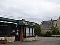 Haynes restaurant (fish and chips) - geograph.org.uk - 5473415.jpg 1,600 × 1,200; 607 KB
-
-
 High Littleton C of E Primary School - geograph.org.uk - 5146047.jpg 2,304 × 1,704; 1.62 MB
-
 High Littleton cemetery - geograph.org.uk - 5146078.jpg 2,304 × 1,704; 1.71 MB
-

-
 High Littleton play area - geograph.org.uk - 5144816.jpg 2,304 × 1,704; 1.66 MB
-
 High Littleton Recreation Club - geograph.org.uk - 5144917.jpg 2,304 × 1,704; 1.49 MB
-
 High Littleton, Somerset - Post Office. (3431576739).jpg 2,752 × 2,295; 3.91 MB
-
 High Street, High Littleton - geograph.org.uk - 991985.jpg 640 × 536; 108 KB
-
 Hilltop power - geograph.org.uk - 5144900.jpg 2,304 × 1,704; 996 KB
-
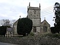
 Holy Trinity, High Littleton - geograph.org.uk - 5146041.jpg 1,704 × 2,304; 1.65 MB
-
 House in Hallatrow - geograph.org.uk - 2861269.jpg 640 × 480; 107 KB
-
 Houses on Timsbury Rd - geograph.org.uk - 2861019.jpg 640 × 480; 74 KB
-
 Milestone, High Littleton - geograph.org.uk - 991996.jpg 640 × 477; 104 KB
-
 Multipurpose bench - geograph.org.uk - 5144874.jpg 1,704 × 2,304; 1.76 MB
-
 No current predictions - geograph.org.uk - 5144944.jpg 2,304 × 1,704; 1.12 MB
-
 Old bus stop sign - geograph.org.uk - 5146023.jpg 2,304 × 1,704; 1.69 MB
-

-

-

-
 Old Tenniscourt Farmhouse - geograph.org.uk - 154905.jpg 640 × 480; 80 KB
-
 Pedestrian crossing, High Street, High Littleton - geograph.org.uk - 5473422.jpg 1,600 × 1,196; 760 KB
-
 Play area with a view - geograph.org.uk - 5144838.jpg 2,304 × 1,704; 1.67 MB
-
 Railway bridge, Hallatrow - geograph.org.uk - 364491.jpg 640 × 480; 112 KB
-
 Rosewell's residents - geograph.org.uk - 5146083.jpg 2,304 × 1,704; 1.56 MB
-
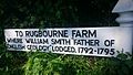 Rugbourne farm sign.jpg 600 × 338; 53 KB
-
 Scumbrum Lane - geograph.org.uk - 5146026.jpg 2,304 × 1,704; 1.6 MB
-
 South east from Langford's Lane - geograph.org.uk - 1087668.jpg 640 × 427; 132 KB
-
 South from Langford's Lane - geograph.org.uk - 1087573.jpg 640 × 469; 154 KB
-
 The Batch, High Littleton - geograph.org.uk - 991980.jpg 640 × 487; 75 KB
-
 The Book Barn - geograph.org.uk - 2861283.jpg 640 × 480; 51 KB
-
 The Bookbarn - a new barn^ - geograph.org.uk - 668976.jpg 640 × 480; 52 KB
-
 The Bookbarn - geograph.org.uk - 668973.jpg 640 × 480; 46 KB
-
 The end of Claremont Gardens on Wells Road - geograph.org.uk - 5473445.jpg 1,600 × 1,281; 824 KB
-
 The green edge of High Littleton - geograph.org.uk - 5473411.jpg 1,600 × 1,200; 677 KB
-
 The Haynes restaurant - geograph.org.uk - 4062643.jpg 3,264 × 2,448; 1.72 MB
-
 The Hurdles - geograph.org.uk - 5144801.jpg 2,304 × 1,704; 1.7 MB
-
 The Old Station Inn - geograph.org.uk - 3451009.jpg 1,600 × 1,071; 310 KB
-
 The Old Station inn, Hallatrow - geograph.org.uk - 5055799.jpg 1,600 × 1,200; 797 KB
-
 The Old Station Pub - geograph.org.uk - 2861279.jpg 640 × 480; 70 KB
-
 The Star in High Littleton - geograph.org.uk - 5144939.jpg 2,304 × 1,704; 1.77 MB
-
 The Star Inn High Littleton - geograph.org.uk - 3249833.jpg 640 × 459; 78 KB
-
 The Star Inn, High Littleton - geograph.org.uk - 5055793.jpg 1,600 × 1,199; 768 KB
-
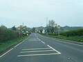
 Wells Road (A39) in Hallatrow - geograph.org.uk - 5473434.jpg 1,600 × 1,200; 709 KB
-
 White Cross from the air - geograph.org.uk - 5688190.jpg 2,558 × 2,257; 474 KB
-
 Your speed - geograph.org.uk - 5146059.jpg 1,704 × 2,304; 1.31 MB
-
 Bluebells in Greyfield Woods - geograph.org.uk - 424514.jpg 640 × 480; 103 KB
-
 Bungay's Hill, High Littleton - geograph.org.uk - 364806.jpg 640 × 426; 73 KB
-

-
 Greyfield Woods - geograph.org.uk - 424507.jpg 480 × 640; 133 KB
-
 Greyfield Woods - geograph.org.uk - 424512.jpg 640 × 480; 111 KB
-
 Road junction in the trees - geograph.org.uk - 400708.jpg 640 × 505; 102 KB


_-_geograph.org.uk_-_5473415.jpg)


.jpg)


_in_Hallatrow_-_geograph.org.uk_-_5473434.jpg)


