Category:Hinderton Hall
| Object location | | View all coordinates using: OpenStreetMap |
|---|
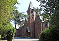
grade II listed English country house in Cheshire, UK  | |||||
| Upload media | |||||
| Instance of | |||||
|---|---|---|---|---|---|
| Location | Neston, Cheshire West and Chester, Cheshire, North West England, England | ||||
| Heritage designation |
| ||||
 | |||||
Media in category "Hinderton Hall"
The following 8 files are in this category, out of 8 total.
-
 Front elevation, Hinderton Hall 1.jpg 4,668 × 3,172; 14.08 MB
-
 Front elevation, Hinderton Hall 2.jpg 4,504 × 3,164; 10.53 MB
-
 Hinderton Hall from Chester High Road 1.jpg 5,184 × 3,456; 8.64 MB
-
 Hinderton Hall from Chester High Road 2.jpg 5,184 × 3,456; 11.71 MB
-
 Hinderton Hall from Chester Road.jpg 4,979 × 3,117; 15.72 MB
-
 Hinderton Hall, Hinderton - geograph.org.uk - 196716.jpg 640 × 480; 38 KB
-
 Rear of Hinderton Hall 1.jpg 4,820 × 3,188; 13.18 MB
-
 Rear of Hinderton Hall 2.jpg 4,556 × 3,192; 15.05 MB


