Category:Hohe Linde
| Object location | | View all coordinates using: OpenStreetMap |
|---|
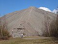
Deutsch: Diese Kategorie enthält Fotos der Halde „Hohe Linde“ in Sangerhausen.
hill in Germany  | |||||
| Upload media | |||||
| Instance of | |||||
|---|---|---|---|---|---|
| Location | Sangerhausen, Mansfeld-Südharz, Saxony-Anhalt, Germany | ||||
 | |||||
Subcategories
This category has the following 2 subcategories, out of 2 total.
*
- Views from Hohe Linde (7 F)
- Remote views of Hohe Linde (31 F)
Media in category "Hohe Linde"
The following 9 files are in this category, out of 9 total.
-
 Hohe Linde 1.jpg 1,600 × 1,200; 276 KB
-
 Hohe Linde 2.jpg 1,200 × 1,600; 348 KB
-
 Hohe Linde 3.jpg 1,200 × 1,600; 344 KB
-
 Kupferhalde.jpg 1,134 × 1,368; 1.3 MB
-
 Lengefeld (Sangerhausen), an der Hohen Linde.jpg 2,551 × 1,701; 1.56 MB
-
 Lengefeld (Sangerhausen), Blick zur Spitzkegelhalde "Hohe Linde".jpg 2,551 × 1,701; 950 KB
-
 Sangerhausen Hohe Linde 01.jpg 3,648 × 2,736; 2.98 MB
-
 Sangerhausen Hohe Linde 02.jpg 3,648 × 2,736; 2.21 MB
-
 Sangerhausen, the cone mine dump "Hohe Linde".jpg 2,551 × 1,701; 1.22 MB


,_an_der_Hohen_Linde.jpg)
,_Blick_zur_Spitzkegelhalde_%22Hohe_Linde%22.jpg)


