Category:Huize Lariks (Zuidlaren)
| Object location | | View all coordinates using: OpenStreetMap |
|---|
building in Tynaarlo, Netherlands  | |||||
| Upload media | |||||
| Instance of | |||||
|---|---|---|---|---|---|
| Location | Zuidlaren, Drenthe, Netherlands | ||||
| Street address |
| ||||
| Located on street |
| ||||
| Heritage designation |
| ||||
| Inception |
| ||||
| Different from | |||||
 | |||||
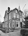
Nederlands: Huize Lariks (1918), Zuidlaren. Vanaf de bouw tot 1958 gemeentehuis.
|
This is a category about rijksmonument number 510914
|
| Address |
|
Media in category "Huize Lariks (Zuidlaren)"
The following 4 files are in this category, out of 4 total.
-
 20191030 huize Lariks Zuidlaren.jpg 4,032 × 3,024; 3.15 MB
-
 Exterieur voorgevel, linker zijgevel - Zuidlaren - 20001841 - RCE.jpg 956 × 1,200; 284 KB
-
 Overzicht De Millystraat - Zuidlaren - 20225625 - RCE.jpg 1,197 × 1,200; 375 KB
-
 Overzicht De Millystraat - Zuidlaren - 20225626 - RCE.jpg 1,200 × 1,195; 425 KB


