Category:Hull's Trace North Huron River Corduroy Segment
 | |||||
| Upload media | |||||
| Instance of | |||||
|---|---|---|---|---|---|
| Location | Michigan | ||||
| Heritage designation | |||||
| Inception |
| ||||
 | |||||
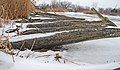
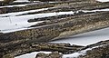
English: Hull's Trace North Huron River Corduroy Segment — in present day Brownstown Charter Township, southern Wayne County, southeastern Michigan.
- The North Huron River Corduroy Segment is a portion of Hull's Trace (also called Hull's Trail), a military road running from Urbana, Ohio to Detroit, Michigan.
- Built in 1812, Hull's Trace was the first military road and first federal road in the United States.
Media in category "Hull's Trace North Huron River Corduroy Segment"
The following 6 files are in this category, out of 6 total.
-
 Hull's Trace Informational Designation.jpg 5,184 × 3,888; 3.87 MB
-
 Hulls Trace 1.webp 624 × 469; 70 KB
-
 Hulls Trace Wayne County MI A.JPG 2,592 × 3,008; 1.47 MB
-
 Hulls Trace Wayne County MI B.JPG 3,555 × 1,980; 1.25 MB
-
 Hulls Trace Wayne County MI C.JPG 3,872 × 2,274; 1.54 MB
-
 Hulls Trace Wayne County MI D.JPG 3,872 × 2,058; 1.43 MB


