Category:Humbleton, East Riding of Yorkshire
English: Humbleton is a village and civil parish in the East Riding of Yorkshire, England, in an area known as Holderness. It is situated approximately 9 miles (14 km) north east of Hull city centre.
village and civil parish in East Riding of Yorkshire, UK  | |||||
| Upload media | |||||
| Instance of | |||||
|---|---|---|---|---|---|
| Location | East Riding of Yorkshire, Yorkshire and the Humber, England | ||||
| Said to be the same as | Humbleton (Wikimedia duplicated page, civil parish) | ||||
 | |||||
Subcategories
This category has the following 3 subcategories, out of 3 total.
Media in category "Humbleton, East Riding of Yorkshire"
The following 83 files are in this category, out of 83 total.
-
 A bend in the road - geograph.org.uk - 45513.jpg 640 × 477; 91 KB
-
 A farm track off Pasture Lane - geograph.org.uk - 2073104.jpg 800 × 600; 337 KB
-
 A minor road towards Humbleton - geograph.org.uk - 2207756.jpg 800 × 600; 316 KB
-
 A minor road towards Humbleton - geograph.org.uk - 2207757.jpg 800 × 600; 191 KB
-
 A unnamed Lane leading to Aldbrough Lane - geograph.org.uk - 2073172.jpg 800 × 600; 296 KB
-
 Aldbrough Lane looking towards Humbleton - geograph.org.uk - 2073198.jpg 800 × 600; 202 KB
-
 Aldbrough Lane towards Humbleton - geograph.org.uk - 2073189.jpg 800 × 600; 243 KB
-
 Animal shelters - geograph.org.uk - 5602958.jpg 1,024 × 768; 146 KB
-
 Ann Watsons Cottages Humbleton.jpg 480 × 640; 95 KB
-
 Barley field at Mill Hill - geograph.org.uk - 5479837.jpg 1,024 × 768; 215 KB
-
 Bend in the road - geograph.org.uk - 45489.jpg 640 × 480; 96 KB
-
 Bracken Hill, Humbleton - geograph.org.uk - 448222.jpg 469 × 640; 132 KB
-
 Bridleway near Sproatley - geograph.org.uk - 1582632.jpg 509 × 640; 158 KB
-
 Bridleway to Lelley - geograph.org.uk - 470073.jpg 640 × 480; 127 KB
-
 Bridleway to Moor Gate - geograph.org.uk - 1411075.jpg 640 × 480; 117 KB
-
 Ch. Saleem Iqbal Chattha.png 1,080 × 1,080; 958 KB
-
 Chopped Rapeseed Crop - geograph.org.uk - 1968703.jpg 3,648 × 2,736; 4.55 MB
-
 Crawforth's Plump - geograph.org.uk - 600253.jpg 640 × 435; 62 KB
-
 Danthorpe Road Humbleton.jpg 640 × 426; 136 KB
-
 Danthorpe Road towards Humbleton - geograph.org.uk - 2100565.jpg 800 × 600; 247 KB
-
 Derelict farm buildings, The Manor, Flinton - geograph.org.uk - 5602949.jpg 1,024 × 768; 140 KB
-
 East of Danthorpe Road, Humbleton - geograph.org.uk - 5513041.jpg 487 × 640; 195 KB
-
 Entering Humbleton on Danthorpe Road - geograph.org.uk - 4982597.jpg 5,184 × 3,888; 6.21 MB
-
 Farm track near Humbleton Hall - geograph.org.uk - 5479476.jpg 1,024 × 768; 173 KB
-
 Farm track, Humbleton - geograph.org.uk - 4666208.jpg 480 × 640; 470 KB
-
 Field Drain - geograph.org.uk - 402802.jpg 640 × 480; 143 KB
-
 Field edge and Fox Covert Drain - geograph.org.uk - 6239564.jpg 4,608 × 3,456; 4.9 MB
-
 Field edge bridleway at Moor Gate - geograph.org.uk - 6239537.jpg 4,608 × 3,456; 4.52 MB
-
 Field headland between Fox Covert Drain and harvested field - geograph.org.uk - 6239555.jpg 4,608 × 3,456; 4.41 MB
-
 Fitling Road towards Fitling - geograph.org.uk - 2207765.jpg 800 × 600; 222 KB
-
 Footpath to Moorgate from Sproatley - geograph.org.uk - 1094147.jpg 640 × 480; 99 KB
-
 Gallows Bridge Road, Humbleton - geograph.org.uk - 525077.jpg 476 × 640; 99 KB
-
 Gargill Close Plantation - geograph.org.uk - 45506.jpg 640 × 480; 75 KB
-
 Harvested field near Humbleton Grange - geograph.org.uk - 5479829.jpg 1,024 × 768; 233 KB
-
 Herons Farm, Flinton - geograph.org.uk - 2100532.jpg 800 × 600; 273 KB
-
 Hoggart Hill, Humbleton - geograph.org.uk - 273457.jpg 480 × 640; 125 KB
-
 Humbleton Beck - geograph.org.uk - 273479.jpg 640 × 447; 119 KB
-
 Humbleton Church in the Snow - geograph.org.uk - 2195979.jpg 3,648 × 2,736; 6.36 MB
-
 Humbleton Hall - geograph.org.uk - 448229.jpg 454 × 640; 113 KB
-
 Humbleton Hall - geograph.org.uk - 448234.jpg 640 × 492; 75 KB
-
 Humbleton Hall - geograph.org.uk - 5513019.jpg 640 × 522; 196 KB
-
 Humbleton Manor.jpg 640 × 480; 112 KB
-
 Humbleton Moor - geograph.org.uk - 448262.jpg 640 × 447; 94 KB
-
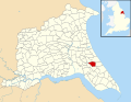 Humbleton UK parish locator map.svg 1,425 × 1,107; 1.68 MB
-
 Ivy Cottage, Humbleton - geograph.org.uk - 5479835.jpg 1,024 × 768; 242 KB
-
 Lane near Sproatley - geograph.org.uk - 1583028.jpg 426 × 640; 150 KB
-
 Long Lane and Moor Cottages - geograph.org.uk - 5504189.jpg 1,024 × 768; 167 KB
-

-

-
 Looking south along Moor Lane, B1238 - geograph.org.uk - 2073137.jpg 800 × 600; 184 KB
-
 Looking towards Gargill Close Plantation in the Snow - geograph.org.uk - 2195985.jpg 3,648 × 2,736; 6.35 MB
-
 Manure heaps on harvested Oil Seed Rape field - geograph.org.uk - 6239569.jpg 4,608 × 3,456; 5.75 MB
-
 Mill Hill Humbleton.jpg 477 × 640; 135 KB
-
 Moor Cottages, Humbleton - geograph.org.uk - 525154.jpg 640 × 420; 89 KB
-
 Muddy track at Gallows Bridge - geograph.org.uk - 5669012.jpg 1,024 × 768; 169 KB
-
 On the Humbleton to Lelley road. - geograph.org.uk - 15386.jpg 640 × 480; 92 KB
-
 Pasture Lane - geograph.org.uk - 5602931.jpg 1,024 × 768; 195 KB
-
 Pasture Lane, Sproatley towards Flinton - geograph.org.uk - 2073095.jpg 800 × 600; 202 KB
-
 Ploughed field near Flinton - geograph.org.uk - 5669010.jpg 1,024 × 768; 180 KB
-
 Ploughed field near Humbleton Hall - geograph.org.uk - 5479470.jpg 1,024 × 768; 178 KB
-
 Potato crop on Humbleton Moor - geograph.org.uk - 5479488.jpg 1,024 × 768; 241 KB
-
 Power lines near Humbleton - geograph.org.uk - 5512997.jpg 480 × 640; 356 KB
-
 Power through the Field - geograph.org.uk - 4947023.jpg 2,535 × 1,769; 968 KB
-
 Road from Burton Constable to Sproatley - geograph.org.uk - 6256402.jpg 1,024 × 769; 138 KB
-
 Shaw Fosse and Humbleton Manor - geograph.org.uk - 448254.jpg 640 × 480; 137 KB
-
 Snow Covered Field near Humbleton - geograph.org.uk - 2195988.jpg 3,648 × 2,736; 6.25 MB
-
 South of Humbleton - geograph.org.uk - 1508392.jpg 640 × 419; 222 KB
-
 Sproatley Road, Flinton - geograph.org.uk - 2073158.jpg 800 × 600; 295 KB
-
 Sproatley Road, Flinton - geograph.org.uk - 2100535.jpg 800 × 600; 320 KB
-
 St Peter's Church, Humbleton - geograph.org.uk - 4982595.jpg 5,184 × 3,888; 7.12 MB
-
 Ten Pound Plantation - geograph.org.uk - 273560.jpg 640 × 480; 104 KB
-
 Ten Pound Plantation^ - geograph.org.uk - 1839380.jpg 2,166 × 2,693; 958 KB
-
 The road to Lelley - geograph.org.uk - 2073220.jpg 800 × 600; 215 KB
-
 The sign for the B1238 - geograph.org.uk - 2073123.jpg 800 × 600; 263 KB
-
 Town End Villas, Humbleton - geograph.org.uk - 2100556.jpg 800 × 600; 285 KB
-
 Trees around Humbleton Hall - geograph.org.uk - 5479840.jpg 1,024 × 768; 187 KB
-
 Trees by Humbleton Beck - geograph.org.uk - 5513044.jpg 640 × 542; 145 KB
-
 View from the churchyard, Humbleton - geograph.org.uk - 5479485.jpg 1,024 × 768; 275 KB
-
 View towards Burton Constable Hall - geograph.org.uk - 5602929.jpg 1,024 × 768; 163 KB
-
 Waiting to be spread - geograph.org.uk - 5602939.jpg 1,024 × 768; 103 KB
-
 West Field, Humbleton - geograph.org.uk - 448258.jpg 640 × 494; 114 KB
-
 West of Humbleton.jpg 640 × 466; 152 KB
-
 Young Trees and Daffodils - geograph.org.uk - 402798.jpg 640 × 480; 89 KB


