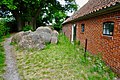
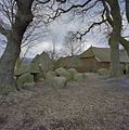
Category:Hunebed D04 in Midlaren
| Object location | | View all coordinates using: OpenStreetMap |
|---|
dolmen in Midlaren, the Netherlands  | |||||
| Upload media | |||||
| Instance of | |||||
|---|---|---|---|---|---|
| Part of | |||||
| Location | Midlaren, Tynaarlo, Drenthe, Netherlands | ||||
| Located on street |
| ||||
| Different from | |||||
 | |||||
|
This is a category about rijksmonument number 45452
|
| Address |
|
Media in category "Hunebed D04 in Midlaren"
The following 14 files are in this category, out of 14 total.
-
 20200520 Hunebed D3 en D4 te Midlaren.jpg 5,184 × 3,456; 5.12 MB
-
 20200520 Hunebed D3a en D4a te Midlaren.jpg 5,184 × 3,456; 4.28 MB
-
 20200520 Hunebed D4 en D3 te Midlaren.jpg 5,184 × 3,456; 5.1 MB
-
 20200520 Hunebed D4 te Midlaren.jpg 5,184 × 3,456; 5.45 MB
-
 20221102 Hunebed D4 Midlaren1.jpg 5,184 × 3,456; 5.22 MB
-
 20221102 Hunebed D4 Midlaren2.jpg 5,184 × 3,456; 5.72 MB
-
 Hunebed D4 Camper (cropped).png 550 × 367; 95 KB
-
 Hunebed D4 Camper.png 1,014 × 493; 264 KB
-
 Hunebed D4 Goedeljee.jpg 2,000 × 1,553; 510 KB
-
 Hunebed D4 te Midlaren.jpg 1,296 × 972; 268 KB
-
 Overzicht hunebedden - Midlaren - 20328561 - RCE.jpg 1,188 × 1,200; 462 KB
-
 Overzicht hunebedden - Midlaren - 20328562 - RCE.jpg 1,189 × 1,200; 469 KB
-
 Overzicht hunebedden - Midlaren - 20328563 - RCE.jpg 1,180 × 1,200; 464 KB
-
 Overzicht hunebedden - Midlaren - 20328564 - RCE.jpg 1,187 × 1,200; 459 KB


.png)


