Category:Hydrographic maps of Seine-Maritime
Subcategories
This category has only the following subcategory.
M
Media in category "Hydrographic maps of Seine-Maritime"
The following 14 files are in this category, out of 14 total.
-
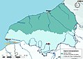
 76-Bassins DCE.jpg 3,507 × 2,480; 1.25 MB
-
 76-Cours eau 50km.jpg 3,507 × 2,480; 445 KB
-
 76-Cours eau-10 km.png 5,457 × 3,543; 1.7 MB
-
 76-Cours eau-50km.png 5,457 × 3,543; 1.12 MB
-
 76-Cours eau-complet.png 5,457 × 3,543; 2.39 MB
-
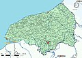
 76-Cours eau.jpg 3,507 × 2,480; 664 KB
-
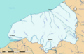
 76-Régions hydro.jpg 3,507 × 2,480; 451 KB
-
 76-Seine-Maritime-Sage.png 3,507 × 2,480; 1.14 MB
-
 76-Sous-Bassins adm.jpg 3,507 × 2,480; 412 KB
-
 76-TRI.jpg 3,507 × 2,480; 449 KB
-
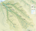 Arques drainage basin-fr.svg 2,258 × 1,975; 2 MB
-
 Bassins du Cailly et de l'Aubette.svg 638 × 861; 1.42 MB
-

-
 Seine river watershed.png 514 × 490; 11 KB


.jpg)