Category:Hydrology of Nebraska
Subcategories
This category has the following 6 subcategories, out of 6 total.
+
B
D
L
O
R
Media in category "Hydrology of Nebraska"
The following 13 files are in this category, out of 13 total.
-
 Aquifers - Denver Basin.png 1,175 × 950; 37 KB
-
-
 Little Blue River Basin, Nebraska Water and related land resources (IA CAT73388422).pdf 1,075 × 1,506, 184 pages; 9.57 MB
-
 Watershed work plan- Sedwick-Sand Draws Watershed, Sedwick County, Colorado, Cheyenne and Duell Counties, Nebraska; (IA CAT76436209).pdf 1,062 × 1,372, 184 pages; 8.82 MB
-
 Sedgwick-Sand Draws Watershed, Cheyenne and Deuel Counties, Nebraska, Sedgwick County, Colorado - watershed work plan (IA CAT76670975).pdf 1,145 × 1,591, 162 pages; 10.08 MB
-

-

-
 South Fork Watershed Project, Pawnee and Richardson Counties, Nebraska - USDA environmental statement (IA CAT77680953).pdf 1,114 × 1,583, 42 pages; 2.1 MB
-
 Republican River Basin, Nebraska - water and related land resources (IA CAT80732021).pdf 970 × 1,493, 296 pages; 20.41 MB
-
 Ground water for irrigation in Lodgepole Valley (IA groundwaterforir00mein).pdf 668 × 1,120, 52 pages; 3.84 MB
-
 Ogallala saturated thickness 1997-sattk97-v2.svg 656 × 960; 1.36 MB
-
 Ogallala saturated thickness 1997-sattk97.svg 1,491 × 1,732; 5.64 MB
-
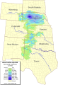
 RepublicanRiverBasin.png 3,401 × 2,201; 169 KB


