Category:Imperial City, Huế
| Imperial City of Hue
|
|||
|---|---|---|---|
.jpg) |
|||
| Native name | Hoàng thành Huế | ||
| Parent institution | Huế citadel | ||
| Location | |||
| Coordinates | | ||
| Established | 1833 | ||
| Authority file | |||
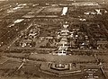
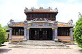
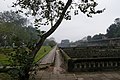
English: The Imperial City is a palace complex located within the citadel of Huế. It was the imperial court during the Nguyen dynasty.
Tiếng Việt: Hoàng Thành là vòng thành thứ hai bên trong Kinh thành Huế, có chức năng bảo vệ các cung điện quan trọng nhất của triều đình, các miếu thờ tổ tiên nhà Nguyễn và bảo vệ Tử Cấm Thành.
walled enclosure within the citadel of Huế, Vietnam  | |||||
| Upload media | |||||
| Instance of | |||||
|---|---|---|---|---|---|
| Part of | |||||
| Location | Huế, Thừa Thiên Huế, Vietnam | ||||
| Has part(s) | |||||
 | |||||
Subcategories
This category has the following 11 subcategories, out of 11 total.
D
- Diên Thọ palace (38 F)
H
- Hien Nhan Gate (12 F)
M
P
- Pavillon of Four Directions (3 F)
T
- Truong Sanh Residence (12 F)
Đ
- Điện Phụng Tiên (2 F)
Media in category "Imperial City, Huế"
The following 174 files are in this category, out of 174 total.
-
 4.4 Hue-23 (36458207732).jpg 4,928 × 3,264; 5.97 MB
-
 Annam - Hué - Les Portiques de Bronze dans le Palais.jpg 1,625 × 1,057; 691 KB
-
 AP1508-Sogny-Marien Hué, 1932 – Vue aérienne du palais impérial.jpg 1,200 × 962; 851 KB
-
 AP1923-Despierres Hué, 1932 – La Ville Impériale – Vue aérienne.jpg 3,235 × 2,371; 3.1 MB
-
 At Hue Citadel 2.JPG 1,944 × 2,592; 1.77 MB
-
 At Hue citadel2.JPG 1,943 × 2,591; 1.08 MB
-
 At Hue Citadel6.JPG 2,592 × 1,944; 1.95 MB
-
 At ImperialCityHuế.JPG 1,941 × 2,589; 1.3 MB
-
 Citadel of Hue 2391558007 906430f821 o.jpg 3,072 × 1,728; 3.17 MB
-
 Citadel of Hue 2391559717 49f24eaa5e o.jpg 2,560 × 1,622; 1.57 MB
-
 Citadel of Hue.jpg 3,294 × 2,284; 2.93 MB
-
 Citadel of Huế 1.jpg 2,298 × 3,456; 3.8 MB
-
 Citdael of Hue 128589408 cdd0232169 o.jpg 891 × 925; 312 KB
-
 Clouds gathering above the imperial city (14556602127).jpg 4,120 × 2,755; 1,006 KB
-
 Dragon décorant - La Cité impériale (Hué).jpg 800 × 1,200; 479 KB
-

-
 Détal du décor dun vase (Cité impériale, Hué) (4381208891).jpg 2,054 × 2,739; 2.81 MB
-
 Ecran du grand palais du Cơ-Mật.jpg 1,811 × 1,083; 675 KB
-
 Ecran du petit palais du Cơ-Mật.jpg 1,083 × 1,811; 358 KB
-
 Elephants in service at the Imperial City Hue.jpg 2,048 × 1,365; 629 KB
-
 Fish in Pond - The Citadel - Hue - Vietnam.JPG 3,072 × 2,304; 3.02 MB
-
 Funny Trees (4328015736).jpg 1,200 × 800; 403 KB
-
 Gate in Imperial City, Huế (I).jpg 4,795 × 3,197; 7.22 MB
-
 Gate in Imperial City, Huế (II).jpg 4,087 × 2,725; 9.41 MB
-
 Gate in Imperial City, Huế (III).jpg 4,189 × 2,766; 8.82 MB
-
 Gate in the Citadel of Huế.jpg 5,184 × 3,888; 7.79 MB
-
 Hien Nhan Gate 20190917.jpg 5,184 × 3,456; 9.23 MB
-
 Hue - Citadel - Royal Enclosure 01.JPG 2,304 × 3,072; 2.99 MB
-
 Hue - Citadel - Royal Enclosure 02.JPG 3,072 × 2,304; 3.05 MB
-
 Hue - Citadel - Royal Enclosure 03.JPG 3,072 × 2,304; 2.99 MB
-
 Hue - Citadel - Royal Enclosure 04.JPG 3,072 × 2,304; 3.14 MB
-
 HUE 3 2016.jpg 2,358 × 2,776; 1.21 MB
-
 Hue Gate, Vietnam.jpg 900 × 1,200; 538 KB
-
 Hue gate.jpg 1,312 × 1,577; 134 KB
-
 Hue Imperial City (14556804807).jpg 4,120 × 2,755; 956 KB
-
 Hue Imperial City (14720155536).jpg 4,120 × 2,755; 1.5 MB
-
 Hue Imperial City (14740173531).jpg 4,120 × 2,755; 1.39 MB
-
 Hue Imperial City (40872823400).jpg 4,565 × 3,043; 2.48 MB
-
 Hue Imperial City (7351251890).jpg 4,392 × 3,280; 3.27 MB
-
 Hue Imperial City Map 1909.jpg 4,017 × 3,185; 2.74 MB
-
 Hue Imperial City-2 (41963749514).jpg 5,184 × 3,456; 5.06 MB
-
 Hue Imperial City-3 (27813229707).jpg 5,060 × 3,456; 7.06 MB
-
 Hue Imperial City-4 (40872816200).jpg 4,653 × 3,102; 4.47 MB
-
 Hue Imperial City-5 (28808589118).jpg 3,456 × 5,184; 6.95 MB
-
 Hue Imperial City-6 (42681762651).jpg 3,456 × 5,184; 6.8 MB
-
 Hue Imperial City-7 (42681758531).jpg 4,883 × 3,255; 6.93 MB
-
 Hue Sity, Vietnam (8104941123).jpg 1,000 × 666; 613 KB
-
 Hue Sity, Vietnam (8104941533).jpg 1,000 × 666; 706 KB
-
 Hue Sity, Vietnam (8104954434).jpg 1,000 × 666; 782 KB
-
 Hue Vietnam Citadel-of-Huế-04.jpg 3,132 × 2,349; 4.55 MB
-
 Hue Vietnam Citadel-of-Huế-05.jpg 3,728 × 2,663; 6.68 MB
-
 Hue Vietnam Citadel-of-Huế-06.jpg 3,987 × 2,848; 11.93 MB
-
 Hue Vietnam Citadel-of-Huế-09.jpg 3,554 × 2,369; 7.9 MB
-
 Hue Vietnam Citadel-of-Huế-10.jpg 4,260 × 2,840; 12.05 MB
-
 Hue Vietnam Citadel-of-Huế-11.jpg 4,241 × 2,827; 9.83 MB
-
 Hue Vietnam Citadel-of-Huế-12.jpg 2,478 × 3,716; 5.91 MB
-
 Hue Vietnam Citadel-of-Huế-13.jpg 3,718 × 2,479; 4.23 MB
-
 Hue Vietnam Citadel-of-Huế-14.jpg 4,272 × 2,848; 10.42 MB
-
 Hue Vietnam Citadel-of-Huế-17.jpg 4,272 × 2,848; 9.63 MB
-
 Hue Vietnam Citadel-of-Huế-18.jpg 3,613 × 1,979; 4.38 MB
-
 Hue Vietnam Citadel-of-Huế-19.jpg 4,130 × 2,753; 4.6 MB
-
 Hue Vietnam Citadel-of-Huế-20.jpg 2,643 × 4,272; 8.64 MB
-
 Hue Vietnam Citadel-of-Huế-22.jpg 2,813 × 2,813; 4.74 MB
-
 Hue Vietnam Citadel-of-Huế-23.jpg 4,178 × 2,785; 10.7 MB
-
 Hue Vietnam Cổng-Trai-cung-01.jpg 4,272 × 2,848; 9.82 MB
-
 Hue Vietnam Hand-truck-in-Càn-Thành-Palace-01.jpg 4,272 × 2,848; 12.77 MB
-
 Hue Vietnam Tiles-in-Càn-Thành-Palace-01.jpg 4,104 × 2,848; 12.03 MB
-
 Hué - Palais Impérial.jpg 2,919 × 2,226; 886 KB
-
 Hué, 1932 – La Ville Impériale – Vue aérienne-2.jpg 2,048 × 1,533; 1.61 MB
-
 Hué, 1932 – La Ville Impériale – Vue aérienne.jpg 3,235 × 2,371; 2.93 MB
-
 Huế - panoramio (2).jpg 3,456 × 2,592; 3.66 MB
-
 Huế citadel.jpg 3,798 × 2,532; 5.56 MB
-
 Hưng Temple.jpg 4,032 × 3,024; 824 KB
-
 Hưng Tổ Miếu 20190917.jpg 5,184 × 3,456; 6.76 MB
-
 Họa tiết trên mái - Cổng trong Đại Nội Huế.jpg 1,811 × 1,083; 466 KB
-
 Họa tiết trên mái trong Đại Nội Huế (2).jpg 1,811 × 1,083; 366 KB
-
 Họa tiết trên mái trong Đại Nội Huế.jpg 1,811 × 1,083; 579 KB
-
 ICHueZitadelle04.jpg 3,237 × 2,170; 1.59 MB
-
 ICHueZitadelle05.jpg 2,504 × 1,658; 982 KB
-
 ICHueZitadelle06.jpg 3,240 × 2,144; 1.65 MB
-
 ICHueZitadelle07.jpg 2,144 × 3,282; 1.84 MB
-
 ICHueZitadelle08.jpg 3,242 × 2,141; 1.6 MB
-
 ICHueZitadelle09.jpg 3,157 × 2,147; 1.13 MB
-
 ICHueZitadelle10.jpg 3,274 × 2,144; 1.81 MB
-
 ICHueZitadelle11.jpg 3,280 × 2,170; 1.57 MB
-
 Imperial City from the north (7166005449).jpg 4,404 × 3,296; 2.78 MB
-
 Imperial City Hue 20190917-2.jpg 5,184 × 3,456; 7.26 MB
-
 Imperial City Hue 20190917-3.jpg 5,184 × 3,456; 7.86 MB
-
 IMPERIAL CITY HUE VIETNAM OCT 2010 (5130912843).jpg 3,648 × 2,736; 3.26 MB
-
 IMPERIAL CITY HUE VIETNAM OCT 2010 (5131546700).jpg 3,648 × 2,736; 3.59 MB
-
 Imperial City, Hue 20190917.jpg 5,184 × 3,456; 7.04 MB
-
 Imperial City, Hue, Vietnam (7073459619).jpg 3,073 × 1,729; 2.42 MB
-
 Imperial City, Hue, Vietnam (7073467857).jpg 3,216 × 1,809; 2.62 MB
-
 Imperial City, Hue, Vietnam (7073483067).jpg 3,216 × 1,808; 4.81 MB
-
 Koi in Hue.jpg 5,184 × 3,888; 6.88 MB
-
 Kriegstrommel Hauptor Königspalast Hue Vietnam.JPG 1,359 × 1,812; 533 KB
-
 Kỳ lân Việt tại Hoàng thành Huế, tháng 3 năm 2021 (1).jpg 2,439 × 2,720; 2.75 MB
-
 Kỳ lân Việt tại Hoàng thành Huế, tháng 3 năm 2021 (2).jpg 2,883 × 3,844; 5.5 MB
-
 Kỳ lân Việt tại Hoàng thành Huế, tháng 3 năm 2021 (3).jpg 2,626 × 3,885; 4.35 MB
-
 Kỳ lân Việt tại Hoàng thành Huế, tháng 3 năm 2021 (4).jpg 2,847 × 3,403; 4.01 MB
-
 Kỳ lân Việt tại Hoàng thành Huế, tháng 3 năm 2021 (5).jpg 3,024 × 3,743; 4.86 MB
-
 La cour des cérémonies (Cité impériale, Hué) (4383069344).jpg 2,932 × 800; 1.7 MB
-
 La céramique de Hué (Cité impériale) (4381965220).jpg 800 × 1,200; 775 KB
-

-
 Licorne (Cité impériale, Hué).jpg 900 × 1,200; 799 KB
-
 Lone Pagoda - Citadel of Hue.jpg 2,000 × 1,500; 2.85 MB
-

-
 Looking toward the Great Palace Gate in the Imperial City of Huế.jpg 10,672 × 2,482; 12.44 MB
-
 Moat around Imperial City (7165988493).jpg 3,312 × 3,888; 2.55 MB
-
 Moat of the Citadel of Hue.jpg 5,184 × 3,888; 5.42 MB
-
 Moat of the Citadel of Huế.jpg 5,105 × 3,694; 3.53 MB
-
 Ngói lưu ly.jpg 1,600 × 1,200; 259 KB
-
 Nhật Thành Pavilion 20190917-1.jpg 5,184 × 3,456; 7.28 MB
-
 Nhật Thành Pavillon 20190917-2.jpg 5,184 × 3,456; 7.85 MB
-
 Plan of Great Enclosure.JPG 966 × 856; 129 KB
-
 Plan of Hue Imperial Citadel.jpg 966 × 1,169; 610 KB
-
 Pordego en la citadelo de Hue 01.jpg 3,072 × 2,304; 1.46 MB
-
 Pordego en la citadelo de Hue.jpg 3,072 × 2,304; 1.48 MB
-
 Porte intérieure (Cité impériale, Hué) (4381216027).jpg 1,600 × 1,200; 1.29 MB
-
 Porte intérieure (Cité impériale, Hué) (4381974590).jpg 1,600 × 1,200; 1.42 MB
-
 Statue at Hue.JPG 1,898 × 2,531; 1.18 MB
-
 Temple du culte du père de la dynastie (Cité impériale, Hué) (4381217729).jpg 800 × 1,200; 721 KB
-
 The Citadel - Drum Tower - Hue - Vietnam.JPG 3,072 × 2,304; 3.19 MB
-
 The Mieu (Temple of the Generations), Citadel, Hue, Vietnam (2524372638).jpg 2,999 × 2,249; 804 KB
-
 Throne (7351159086).jpg 4,122 × 3,250; 3.62 MB
-
 Thái Bình Pavilion 20190917.jpg 5,184 × 3,456; 6.6 MB
-
 Trường An Môn.jpg 5,184 × 3,456; 8.79 MB
-
 Tu Cam Thanh (Hue).jpg 290 × 264; 52 KB
-
 Vietnam & Cambodia (3336780185).jpg 1,280 × 1,177; 347 KB
-
 Vietnam & Cambodia (3337609136).jpg 1,280 × 1,029; 287 KB
-
 Vietnam & Cambodia (3337610956).jpg 1,280 × 853; 248 KB
-
 Vietnam 010 (6693190717) (3).jpg 2,592 × 1,944; 1.09 MB
-
 Vietnam 013 (6693191209) (2).jpg 2,592 × 1,944; 1.46 MB
-
 Vietnam 014 (6693191371) (3).jpg 2,592 × 1,944; 1.88 MB
-
 Vietnam 015 (6693191527) (2).jpg 2,592 × 1,944; 1.28 MB
-
 Vietnam 016 (6693191659) (3).jpg 2,592 × 1,944; 1.22 MB
-
 Vietnam 017 (6693191803) (3).jpg 2,592 × 1,944; 1.18 MB
-
 Vietnam 018 (6693191919) (3).jpg 2,592 × 1,944; 1.35 MB
-
 Vietnam 019 (6693192019) (3).jpg 2,592 × 1,944; 1.41 MB
-
 Vietnam 020 (6693192153) (3).jpg 2,592 × 1,944; 2.01 MB
-
 Vietnam 021 (6693192251) (3).jpg 2,592 × 1,944; 1.55 MB
-
 Vietnam 022 (6693192475) (3).jpg 2,592 × 1,944; 1.78 MB
-
 Vietnam 023 (6693192623).jpg 2,592 × 1,944; 1.48 MB
-
 Vietnam 024 (6693192811) (3).jpg 2,592 × 1,944; 1.44 MB
-
 Vietnam 025 (6693192991) (3).jpg 2,592 × 1,944; 1.86 MB
-
 Vietnam 028 (6693193419) (3).jpg 2,592 × 1,944; 1.38 MB
-
 Vietnam 029 (6693193573) (3).jpg 2,592 × 1,944; 1.59 MB
-
 Vietnam 030 (6693193729) (3).jpg 2,592 × 1,944; 1.24 MB
-
 Vietnam 031 (6693193871) (3).jpg 2,592 × 1,944; 1.59 MB
-
 Vietnam 032 (6693194005) (3).jpg 2,592 × 1,944; 1.7 MB
-
 Vietnam 033 (6693194135) (3).jpg 2,592 × 1,944; 1.7 MB
-
 Vietnam 034 (6693194213) (3).jpg 2,592 × 1,944; 1.03 MB
-
 Vietnam 036 (6693194501) (3).jpg 2,592 × 1,944; 1.37 MB
-
 Vietnam 037 (6693194645) (3).jpg 2,592 × 1,944; 1.51 MB
-
 Vietnam 040 (6693195035) (3).jpg 1,944 × 2,592; 1.3 MB
-
 Vietnam 043 (6693195493) (2).jpg 1,944 × 2,592; 1.61 MB
-
 Vietnam 044 (6693195613) (2).jpg 2,592 × 1,944; 1.41 MB
-
 Vietnam, Hue, Imperial City of Hue, Chinese inscriptions.jpg 3,984 × 2,656; 5.74 MB
-
 Vietnam, Hue, Imperial City of Hue, Enclosure.jpg 3,984 × 2,656; 4.89 MB
-
 Vietnam, Hue, Imperial City of Hue, Gate.jpg 3,984 × 2,656; 4.9 MB
-
 Vietnam, Hue, Imperial City of Hue, Inner grounds.jpg 3,984 × 2,656; 4.73 MB
-
 Vietnam, Hue, Imperial City of Hue, Moat.jpg 3,984 × 2,656; 4.04 MB
-
 Vietnam, Hue, Imperial City of Hue, Trees.jpg 3,984 × 2,656; 4.93 MB
-
 Vietnam, Hue, Imperial City of Hue, Walls.jpg 3,984 × 2,656; 3.97 MB
-
 Vietnam, Hue, Imperial City of Hue.jpg 3,984 × 2,656; 4.67 MB
-
 Vietnamese Guard Atop Citadel, 1969 (15808125643).jpg 1,350 × 1,913; 174 KB
-
 VietnamMarschplatz.jpg 1,948 × 1,227; 253 KB
-
 Vn-hue-königsst-29-07-07.jpg 1,536 × 1,152; 330 KB
-
 Wall painting (7351149390).jpg 3,275 × 4,063; 2.27 MB
-
 Zitadelle Detailansicht Hue Vietnam.JPG 1,768 × 1,326; 734 KB
-
 Điện Quang Minh 20190917-1.jpg 5,184 × 3,456; 7.19 MB
-
 Điện Quang Minh 20190917-2.jpg 5,184 × 3,456; 7.57 MB
-
 Điện Quang Minh 20190917-3.jpg 3,456 × 5,184; 7.78 MB
-
 Đầu rồng, Huế.jpg 1,600 × 1,200; 254 KB
.jpg)


.jpg)
.jpg)
_(4381977782).jpg)
_(4381208891).jpg)


.jpg)
.jpg)
.jpg)
.jpg)


.jpg)
.jpg)
.jpg)
.jpg)
.jpg)

.jpg)
.jpg)
.jpg)
.jpg)
.jpg)
.jpg)
.jpg)
.jpg)
.jpg)


.jpg)


.jpg)


.jpg)


.jpg)
.jpg)

.jpg)
.jpg)
.jpg)


.jpg)
.jpg)
.jpg)
.jpg)
.jpg)
_(4381965220).jpg)
_(4381219337).jpg)
.jpg)

.jpg)


_(4381216027).jpg)
_(4381974590).jpg)

_(4381217729).jpg)

,_Citadel,_Hue,_Vietnam_(2524372638).jpg)
.jpg)


.jpg)
.jpg)
.jpg)
.jpg)
_(3).jpg)
_(2).jpg)
_(3).jpg)
_(2).jpg)
_(3).jpg)
_(3).jpg)
_(3).jpg)
_(3).jpg)
_(3).jpg)
_(3).jpg)
_(3).jpg)
.jpg)
_(3).jpg)
_(3).jpg)
_(3).jpg)
_(3).jpg)
_(3).jpg)
_(3).jpg)
_(3).jpg)
_(3).jpg)
_(3).jpg)
_(3).jpg)
_(3).jpg)
_(3).jpg)
_(2).jpg)
_(2).jpg)


.jpg)


.jpg)


_(4383069344).jpg)
_from_the_Palace_of_Dien_Tho_(Cung_Di%C3%AAn_Th%E1%BB%8D).jpg)