Category:Indonesia maps by U.S. Army Map Service
Media in category "Indonesia maps by U.S. Army Map Service"
The following 16 files are in this category, out of 16 total.
-
 Aru North txu-oclc-6558822-sb53-2.jpg 4,326 × 4,797; 3.34 MB
-
 Aru South txu-oclc-6558822-sb53-5.jpg 4,288 × 4,790; 3.24 MB
-
 Aru txu-oclc-6558822-sb53-2+5.jpg 2,277 × 3,447; 809 KB
-
 Aru txu-oclc-6558822-sb53-2+5.png 2,277 × 3,447; 22.5 MB
-
 Bojonegoro map from us army map service.png 560 × 533; 678 KB
-
 Karte Pulau Nias.jpg 4,619 × 4,458; 4.96 MB
-
 Karte Pulau Sumba.jpg 6,405 × 3,615; 5.05 MB
-
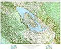 Map of Lake Toba.jpg 4,037 × 3,282; 4.76 MB
-
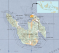
 Nusakambangan map from AMS in UTexas Library.png 1,154 × 458; 1.42 MB
-
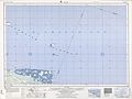 Schouten Islands (Papua New Guinea) txu-oclc-6552576-sa55-13.jpg 5,000 × 3,769; 2.67 MB
-
 Tarakan region 1961 map.jpg 5,000 × 3,825; 3.18 MB
-
 USAMS New Guinea Map Series T401 SA 53-5 Geelvink Bay.jpg 4,308 × 4,757; 3.8 MB
-
 Weh Island.png 800 × 718; 1.17 MB
-
 Yos Sudarso NE txu-oclc-6552576-sb54-13.jpg 5,000 × 3,395; 3.01 MB
-
 Yos Sudarso SE txu-oclc-6552576-sc54-1.jpg 5,000 × 3,751; 3.37 MB
-
 Yos Sudarso SW txu-oclc-6552576-sc53-4.jpg 5,000 × 3,754; 2.55 MB


_txu-oclc-6552576-sa55-13.jpg)


