Category:Irby Road - Grange Road footpath
| Object location | | View all coordinates using: OpenStreetMap |
|---|
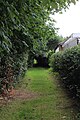
This short footpath (85 yards) runs between the houses. It predates the housing around it and was marks on maps in c. 1875, with a well marked on it.
Media in category "Irby Road - Grange Road footpath"
The following 6 files are in this category, out of 6 total.
-
 Irby Road - Grange Road footpath 1.jpg 3,456 × 5,184; 10.48 MB
-
 Irby Road - Grange Road footpath 2.jpg 3,456 × 5,184; 12.2 MB
-
 Irby Road - Grange Road footpath 3.jpg 3,144 × 4,566; 7.46 MB
-
 Irby Road - Grange Road footpath 4.jpg 3,276 × 4,938; 9.97 MB
-
 Irby Road - Grange Road footpath 5.jpg 5,008 × 3,304; 9.78 MB
-
 Irby Road - Grange Road footpath 6.jpg 5,024 × 3,308; 7.93 MB


