Category:Islam distribution maps of India
Countries of Asia: People's Republic of China · Georgia‡ · India · Russia‡
‡: partly located in Asia
‡: partly located in Asia
Media in category "Islam distribution maps of India"
The following 21 files are in this category, out of 21 total.
-

-
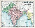 Brit IndianEmpireReligions3.jpg 1,534 × 1,241; 2.33 MB
-
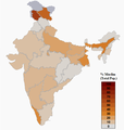
 District wise Muslim population percentage India census 2011.png 1,574 × 1,738; 778 KB
-
 INDIA.PERCENTAGE OF MUSLIMS BY TEHSILS. ACCORDING TO THE 2001 CENSUS.png 1,638 × 1,852; 335 KB
-
 Islam in India (2011).svg 1,643 × 1,856; 257 KB
-
 Islam In India By Population.png 3,818 × 4,600; 765 KB
-
 Islam In India.png 2,000 × 2,208; 871 KB
-
 Islam-India-states-2.png 1,594 × 1,868; 550 KB
-
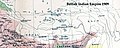 Map of Tibet in 1909 (cropped).jpg 834 × 333; 416 KB
-
 Muslim Demographics of India.png 582 × 614; 59 KB
-
 Muslim In India By Percentage.png 3,818 × 4,600; 1,009 KB
-
 Muslim percent 1909.jpg 2,358 × 1,970; 2.29 MB
-
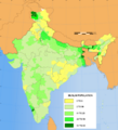 Muslim population in India, 2001.png 543 × 599; 251 KB
-
 Muslim Population in India.png 2,000 × 2,208; 871 KB
-
 Muslim Population-Districts of Assam (2014).svg 765 × 633; 90 KB
-
 Percentage of Muslim population in West Bengal.svg 512 × 534; 461 KB
-
 Uttar Pradesh Muslim percentage 2011.svg 800 × 750; 618 KB
-
 Uttar Pradesh religion 2011.png 8,182 × 8,510; 4.01 MB
-
 Verbreitung des Islam in Indien 2001.png 1,719 × 1,936; 600 KB
-
 WestBengalDistricts muslim population.svg 576 × 601; 150 KB
-
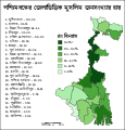 পশ্চিমবঙ্গের জেলাভিত্তিক মুসলিম জনসংখ্যার হার.svg 512 × 534; 68 KB


.svg)


.svg)


.jpg)