Category:John Bartholomew and Son
Subcategories
This category has only the following subcategory.
Media in category "John Bartholomew and Son"
The following 30 files are in this category, out of 30 total.
-
 1889 map of the world - British Imperial Federation map of the world.tif 5,832 × 4,385; 73.18 MB
-
 1891 Scotland Languages.jpg 633 × 858; 234 KB
-
 1912 China map from National Geographic.jpg 6,980 × 5,326; 10.65 MB
-
 Aldwych in 1900 (station location).png 409 × 295; 284 KB
-
 Bartholomew Collection map J. G.jpg 230 × 179; 33 KB
-
 Bartholomew's chart of the world on Mercator's projection (14719827322).jpg 2,000 × 1,277; 2.59 MB
-
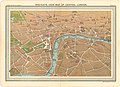 Bird's-Eye View Map of Central London.jpg 5,226 × 3,773; 6.98 MB
-

-
 EB9 Abyssinia.png 1,229 × 1,409; 2.35 MB
-
 EB9 Africa sepia.png 2,638 × 3,792; 12.16 MB
-
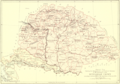 EB9 Hungary CSS.png 3,740 × 2,625; 13.71 MB
-
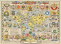
 EB9 Hungary RSP.png 3,590 × 2,515; 14.08 MB
-
 EB9 Huntingdon & Cambridge RSP.png 2,512 × 3,512; 15.35 MB
-
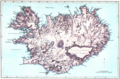 EB9 Iceland ACB.png 772 × 509; 1,013 KB
-
 EB9 Iceland RSP.png 2,850 × 1,857; 9.05 MB
-
 EB9 Iceland.jpg 2,572 × 1,672; 1.38 MB
-
 EB9 Lincoln - map.jpg 2,608 × 3,695; 2.18 MB
-
 EB9 New Brunswick.png 3,708 × 2,642; 12.27 MB
-
 EB9 Norway & Sweden.jpg 1,827 × 2,636; 2.45 MB
-
 EB9 Ohio - geological map.jpg 1,263 × 1,415; 316 KB
-
 EB9 Scarborough - plan.jpg 1,159 × 1,542; 819 KB
-
 EB9 Vichy.jpg 806 × 995; 449 KB
-

-
 Modern Hy (Iona) by John Bartholomy 1874.jpg 2,268 × 4,140; 1.11 MB
-

-

-
 Sketch Chart of Abyssinia.png 1,291 × 1,546; 2.52 MB
-
 Sketch Map of the English Lake District - The English Lakes.jpg 2,025 × 3,372; 1.6 MB
-
 Story of Burnt Njal Iceland.png 3,924 × 2,645; 20 MB
-
 United Nations Map of the World.jpg 11,103 × 8,188; 23.92 MB


.png)

.jpg)

.jpg)


.jpg)
_by_John_Bartholomy_1874.jpg)


