Category:June 2007 on the Isle of Wight
English: Images/pictures taken on the Isle of Wight during June 2007. Note this is not the date of the upload, nor the date a photo was scanned.
| June 2006 | ← | June 2007 | → | June 2008 | |||||||
| Jan | Feb | Mar | Apr | May | Jun | Jul | Aug | Sep | Oct | Nov | Dec |
Subcategories
This category has only the following subcategory.
I
- Isle of Wight Festival 2007 (23 F)
Media in category "June 2007 on the Isle of Wight"
The following 65 files are in this category, out of 65 total.
-
 Approaching Kern - geograph.org.uk - 473413.jpg 640 × 477; 86 KB
-
 Approaching Pagham Farm - geograph.org.uk - 485456.jpg 640 × 477; 103 KB
-
 Arreton Manor pub.jpg 1,600 × 1,206; 522 KB
-
 Arreton Manor tools.jpg 1,600 × 1,206; 502 KB
-
 Barn at Guildford Farm - geograph.org.uk - 472518.jpg 640 × 477; 113 KB
-
 Blacklands Road bridge - geograph.org.uk - 472492.jpg 640 × 477; 145 KB
-
 Bridleway to Kern - geograph.org.uk - 484427.jpg 640 × 477; 113 KB
-
 Byway towards Knighton - geograph.org.uk - 473398.jpg 640 × 477; 114 KB
-
 Cyclist on NCN 23 - geograph.org.uk - 485472.jpg 640 × 477; 150 KB
-
 Decaying shed on Isle of Wight - geograph.org.uk - 471516.jpg 640 × 477; 136 KB
-
 Depot entrance - geograph.org.uk - 469803.jpg 640 × 477; 91 KB
-
 Doreshill Farm - geograph.org.uk - 472499.jpg 640 × 477; 96 KB
-
 Dual cabbageways near NCN23 - geograph.org.uk - 469798.jpg 640 × 477; 100 KB
-
 End of cycle track - geograph.org.uk - 469788.jpg 640 × 477; 109 KB
-
 Farmland at Little Budbridge - geograph.org.uk - 485449.jpg 640 × 477; 120 KB
-
 Farmland at Nunwell Farm - geograph.org.uk - 471546.jpg 640 × 477; 112 KB
-
 Field near Hill Farm - geograph.org.uk - 469535.jpg 640 × 477; 104 KB
-
 Flickr - ronsaunders47 - Ventnor Marina. 3 Isle of Wight..jpg 2,733 × 1,805; 976 KB
-
 Footpath towards Bohemia - geograph.org.uk - 485444.jpg 640 × 477; 83 KB
-
 Footpath towards Merstone - geograph.org.uk - 485467.jpg 640 × 477; 112 KB
-
 Freshwater Bay bus stop flags.JPG 2,048 × 1,536; 1.03 MB
-
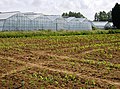 Greenhouses at Great Budbridge Manor - geograph.org.uk - 469768.jpg 640 × 477; 126 KB
-
 Junction of many ways - geograph.org.uk - 469729.jpg 640 × 477; 152 KB
-
 Knighton - geograph.org.uk - 469639.jpg 640 × 477; 96 KB
-
 Knighton-Gorges.jpg 640 × 477; 132 KB
-
 Little Budbridge Farm - geograph.org.uk - 469762.jpg 640 × 477; 121 KB
-
 Little East Standen Farm - geograph.org.uk - 485401.jpg 640 × 477; 97 KB
-
 Meadow near Blackwater - geograph.org.uk - 485485.jpg 640 × 477; 82 KB
-
 NCN 23 - geograph.org.uk - 485434.jpg 640 × 477; 105 KB
-
 Old railway line approaching Newport - geograph.org.uk - 470701.jpg 640 × 477; 129 KB
-

-

-
 Part of Bembridge Foreland - geograph.org.uk - 484644.jpg 640 × 477; 108 KB
-
 Residents of Blacklands Lane - geograph.org.uk - 471508.jpg 640 × 477; 89 KB
-
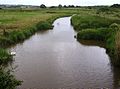 River Yar - geograph.org.uk - 484532.jpg 640 × 477; 80 KB
-
 Sand bag wall - geograph.org.uk - 471492.jpg 640 × 477; 135 KB
-
 Shide Corner - geograph.org.uk - 485508.jpg 640 × 477; 73 KB
-
 Southern Vectis 455 HW07 CXV 2.JPG 640 × 478; 80 KB
-
 Southern Vectis 455 HW07 CXV 3.JPG 640 × 478; 76 KB
-
 Southern Vectis 455 HW07 CXV launch.JPG 1,039 × 466; 86 KB
-
 Southern Vectis 455 HW07 CXV offside front.JPG 640 × 479; 36 KB
-
 Southern Vectis 455 HW07 CXV offside rear.JPG 640 × 479; 39 KB
-
 Southern Vectis 455 HW07 CXV rear.JPG 640 × 478; 61 KB
-
 Southern Vectis 455 HW07 CXV.JPG 384 × 285; 48 KB
-
 Southern Vectis 753 R753 GDL rear 2.JPG 2,048 × 1,536; 893 KB
-
 Stickworth Farm Cottage - geograph.org.uk - 485431.jpg 640 × 477; 107 KB
-
 Stiles near Guildford Farm - geograph.org.uk - 472523.jpg 640 × 477; 131 KB
-
 Strange trees - geograph.org.uk - 469756.jpg 640 × 477; 93 KB
-
 Sweetcorn east of Arreton - geograph.org.uk - 485415.jpg 640 × 477; 119 KB
-
 Sweetcorn underway - geograph.org.uk - 469735.jpg 640 × 477; 127 KB
-
 Towards Stickworth Hall - geograph.org.uk - 469746.jpg 640 × 477; 98 KB
-
 Approaching Combley Farm - geograph.org.uk - 472547.jpg 640 × 477; 96 KB
-
 Approaching Nunwell Farm - geograph.org.uk - 484461.jpg 640 × 477; 97 KB
-
 Barn at Combley Farm - geograph.org.uk - 472549.jpg 640 × 477; 103 KB
-
 Durton Farm - geograph.org.uk - 469715.jpg 640 × 477; 95 KB
-
 Great Briddlesford Farm - geograph.org.uk - 469595.jpg 640 × 477; 82 KB
-
 Great Briddlesford Farm - geograph.org.uk - 471510.jpg 640 × 477; 94 KB
-
 Great Briddlesford Farm - geograph.org.uk - 472512.jpg 640 × 477; 112 KB
-
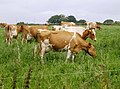
 Horse at Pagham - geograph.org.uk - 469775.jpg 640 × 477; 108 KB
-
 Kern farmhouse - geograph.org.uk - 473419.jpg 640 × 477; 113 KB
-
 Little Fairlee Farm - geograph.org.uk - 471502.jpg 640 × 477; 91 KB
-
 New barns at Little Duxmore - geograph.org.uk - 471531.jpg 640 × 477; 87 KB
-
 Nunwell Farm - geograph.org.uk - 469674.jpg 640 × 477; 115 KB
-
 Nunwell Farm - geograph.org.uk - 484459.jpg 640 × 477; 79 KB
-
 Storage at New Fairlee Farm - geograph.org.uk - 469575.jpg 640 × 477; 92 KB


