Category:Köppen climate classification maps of Canada
Media in category "Köppen climate classification maps of Canada"
The following 34 files are in this category, out of 34 total.
-
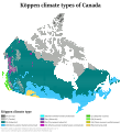 Canada Köppen.svg 1,170 × 1,278; 3.85 MB
-
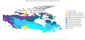
 Koppen-Geiger Map CAN present.svg 1,816 × 850; 23.05 MB
-
 Koppen-Geiger Map CAN future.svg 1,816 × 850; 23.59 MB
-
 Alberta Köppen.png 5,400 × 10,800; 399 KB
-
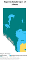
 Alberta Köppen.svg 810 × 1,620; 541 KB
-
 British Columbia Köppen.png 5,400 × 6,300; 766 KB
-
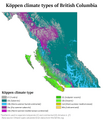
 British Columbia Köppen.svg 810 × 918; 2 MB
-
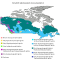
 Canada Köppen-ru.svg 1,297 × 1,359; 3.96 MB
-
 Canada map of Köppen climate classification (hy).svg 1,900 × 1,900; 1.11 MB
-
 Canada map of Köppen climate classification.svg 1,900 × 1,900; 1.31 MB
-
 Klimata mapo Kebekio Köppen.svg 900 × 1,350; 1.09 MB
-
 KoppenSWOntario.png 1,024 × 1,198; 146 KB
-
 Manitoba Köppen.svg 720 × 1,278; 454 KB
-
 Maritimes Köppen.svg 900 × 891; 1.3 MB
-
 Neufundland & Labrador Köppen-Klima.svg 464 × 728; 1.2 MB
-
 New Brunswick Köppen.svg 900 × 1,170; 426 KB
-
 Newfoundland and Labrador Köppen (in Portuguese).svg 607 × 1,038; 234 KB
-
 Newfoundland and Labrador Köppen.svg 810 × 1,440; 1.47 MB
-
 Newfoundland Köppen.svg 810 × 1,260; 478 KB
-
 Northwest Territories Köppen.svg 765 × 1,152; 1.51 MB
-
 Nouveau-Brunswick Köppen.svg 900 × 1,170; 488 KB
-
 Nouvelle-Écosse Köppen.svg 900 × 945; 580 KB
-
 Nova Scotia Köppen.svg 900 × 945; 583 KB
-
 Nunavut Köppen.svg 765 × 1,013; 1.17 MB
-
 Ontario Köppen.svg 900 × 1,053; 484 KB
-
 Prairie Provinces Köppen.svg 846 × 882; 625 KB
-
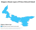 Prince Edward Island Köppen.svg 900 × 738; 353 KB
-
 Quebec Köppen.svg 900 × 1,305; 927 KB
-
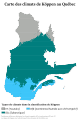 Québec fr Köppen.svg 900 × 1,350; 1.33 MB
-
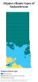 Saskatchewan Köppen.svg 720 × 1,530; 425 KB
-
 Vancouver Gulf Köppen.png 5,400 × 6,031; 315 KB
-
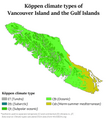
 Vancouver Gulf Köppen.svg 810 × 905; 577 KB
-
 Western Canada Köppen.svg 1,170 × 756; 2.02 MB
-
 Yukon Köppen.svg 765 × 1,197; 1 MB


.svg)


.svg)


